TopoQuest Logo
Do you find TopoQuest useful?
Help keep TopoQuest running and adding new maps/features by donating!
Bitcoin:  19c7KJd3qBynnjoSw5npx9KScwjBe4ifkT
Litecoin:  LXs6TkuXGGXo1vDsWCkWVdjQX94eUKd6ui
Home View Maps Find Maps Find Places Resources & Links


Saint Johns Park, Florida Topographic Map

USGS Map Title: Saint Johns Park, FL
USGS Map MRC: 29081D4
DRG (GeoTIFF) Download: o29081d4.tif


Neighboring USGS Topographic Map Quads:


  San Mateo, FL  
29081E5
 

  Dinner Island, FL  
29081E4
 

  Espanola, FL  
29081E3
 

  Crescent City, FL  
29081D5
 

  Saint Johns Park, FL  
29081D4
 

  Bunnell, FL  
29081D3
 

  Welaka SE, FL  
29081C5
 

  Seville, FL  
29081C4
 

  Codys Corner, FL  
29081C3


Map MRC Location:

N30°
W82°
N30°
W81°
H8 H7 H6 H5 H4 H3 H2 H1
G8 G7 G6 G5 G4 G3 G2 G1
F8 F7 F6 F5 F4 F3 F2 F1
E8 E7 E6 E5 E4 E3 E2 E1
D8 D7 D6 D5 D4 D3 D2 D1
C8 C7 C6 C5 C4 C3 C2 C1
B8 B7 B6 B5 B4 B3 B2 B1
A8 A7 A6 A5 A4 A3 A2 A1
N29°
W82°
N29°
W81°

Saint Johns Park, FL USGS 1:24K Topographic Map Preview:
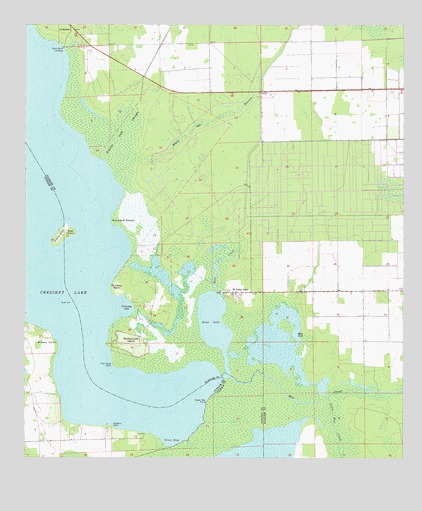
Saint Johns Park, FL USGS Topographic Map
Click on map above to begin viewing in our Map Viewer.

This topographic map contains these locations and features:
Feature Name Type Latitude Longitude GNIS ID View Map
AndalusiaPopulated PlaceN29.5000°W81.4848°295092View Map
Bear IslandIslandN29.4397°W81.4876°278328View Map
Breezy PointCapeN29.4086°W81.4887°279356View Map
Bull CreekStreamN29.4225°W81.4356°279636View Map
Bull Creek Mobile Home ParkPopulated PlaceN29.4231°W81.4349°2447920View Map
Buzzard RoostCapeN29.4428°W81.4698°279769View Map
Dead LakeLakeN29.4149°W81.4375°281379View Map
Fish Hawk PointCapeN29.4019°W81.4706°282483View Map
Flagler County Sheriff's Office West Side SubstationBuildingN29.4602°W81.4155°2756132View Map
Green BayBayN29.3840°W81.4480°283368View Map
Green Bay PointCapeN29.3916°W81.4398°283372View Map
Grimsley CoveBayN29.4186°W81.4683°283455View Map
Grimsley NeckCapeN29.4236°W81.4717°283456View Map
Hanks Hideaway Mobile Home ParkPopulated PlaceN29.4221°W81.4326°2447921View Map
Haw CreekStreamN29.3986°W81.4340°283822View Map
Hopkins PointCapeN29.3847°W81.4709°284262View Map
Little Haw CreekStreamN29.3930°W81.3992°285707View Map
McReynolds IslandIslandN29.4078°W81.4637°286655View Map
Mud LakeLakeN29.4069°W81.4187°287412View Map
New RunPopulated PlaceN29.3839°W81.3845°300897View Map
Saint Johns ParkPopulated PlaceN29.4230°W81.4312°290233View Map
Shell Bluff LandingLocaleN29.4936°W81.4876°295618View Map
Shirley PlacePopulated PlaceN29.3986°W81.4901°300898View Map
Skinners Wholesale Nursery AirportAirportN29.4048°W81.4960°309346View Map
White Oak BranchSwampN29.4722°W81.4390°293211View Map
White Oak SwampSwampN29.4582°W81.4695°293216View Map

Note: Coordinates in the location and feature list above are referenced to NAD83 datum.


Copyright (C) 2008-2025 Ryan Niemi / Sunset Dynamics ... All Rights Reserved