TopoQuest Logo
Do you find TopoQuest useful?
Help keep TopoQuest running and adding new maps/features by donating!
Bitcoin:  19c7KJd3qBynnjoSw5npx9KScwjBe4ifkT
Litecoin:  LXs6TkuXGGXo1vDsWCkWVdjQX94eUKd6ui
Home View Maps Find Maps Find Places Resources & Links


Satsuma, Florida Topographic Map

USGS Map Title: Satsuma, FL
USGS Map MRC: 29081E6
DRG (GeoTIFF) Download: o29081e6.tif


Neighboring USGS Topographic Map Quads:


  Baywood, FL  
29081F7
 

  Palatka, FL  
29081F6
 

  Hastings, FL  
29081F5
 

  Rodman, FL  
29081E7
 

  Satsuma, FL  
29081E6
 

  San Mateo, FL  
29081E5
 

  Lake Delancy, FL  
29081D7
 

  Welaka, FL  
29081D6
 

  Crescent City, FL  
29081D5


Map MRC Location:

N30°
W82°
N30°
W81°
H8 H7 H6 H5 H4 H3 H2 H1
G8 G7 G6 G5 G4 G3 G2 G1
F8 F7 F6 F5 F4 F3 F2 F1
E8 E7 E6 E5 E4 E3 E2 E1
D8 D7 D6 D5 D4 D3 D2 D1
C8 C7 C6 C5 C4 C3 C2 C1
B8 B7 B6 B5 B4 B3 B2 B1
A8 A7 A6 A5 A4 A3 A2 A1
N29°
W82°
N29°
W81°

Satsuma, FL USGS 1:24K Topographic Map Preview:
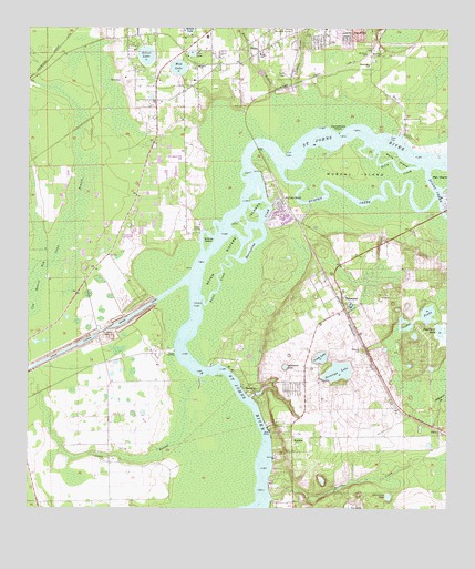
Satsuma, FL USGS Topographic Map
Click on map above to begin viewing in our Map Viewer.

This topographic map contains these locations and features:
Feature Name Type Latitude Longitude GNIS ID View Map
Acosta CreekStreamN29.5030°W81.6770°277670View Map
All Saints Anglican ChurchChurchN29.6184°W81.7036°2451685View Map
Alligator LakeLakeN29.5370°W81.6728°277796View Map
Bainbridge Road Mobile Home ParkPopulated PlaceN29.6231°W81.6595°2451679View Map
Barrentine CreekChannelN29.5722°W81.6795°278126View Map
Browns LandingLocaleN29.5972°W81.6381°295155View Map
Buffalo BluffPopulated PlaceN29.5797°W81.6737°279620View Map
Calvary Baptist ChurchChurchN29.6247°W81.6614°2512768View Map
Camp BranchSwampN29.5766°W81.7370°279878View Map
Camp BranchStreamN29.5344°W81.6987°279870View Map
Castle LakeLakeN29.5396°W81.6624°280124View Map
Christ Independent Methodist ChurchChurchN29.6247°W81.6717°2512749View Map
Church of Christ of WestsideChurchN29.6110°W81.6998°2451691View Map
Church of Life TabernacleChurchN29.5900°W81.7028°2512748View Map
City of Palatka Wastewater Treatment PlantLocaleN29.6161°W81.6511°2451659View Map
Clearwater LakeLakeN29.5033°W81.6421°280553View Map
Crane PondsLakeN29.5509°W81.6304°281002View Map
Cross Florida Barge CanalCanalN29.5375°W81.7468°305530View Map
Devall BranchStreamN29.6075°W81.6770°281521View Map
Domingo Acosta GrantCivilN29.5058°W81.6715°306958View Map
Dunns CreekStreamN29.5889°W81.6304°281881View Map
Ezra's Landing Mobile Home ParkPopulated PlaceN29.6197°W81.6488°2451674View Map
Grace Community Baptist ChurchChurchN29.6117°W81.7001°2451700View Map
Grand View GrovePopulated PlaceN29.5214°W81.6784°295044View Map
Horse LandingLocaleN29.5411°W81.7062°295360View Map
Horseshoe PointCapeN29.5983°W81.6573°284323View Map
Isabellas Place Mobile Home ParkPopulated PlaceN29.6197°W81.6489°2451675View Map
Lake MyraLakeN29.5531°W81.6534°287500View Map
Lib Field (historical)AirportN29.5211°W81.6320°309958View Map
Liberty Baptist ChurchChurchN29.6129°W81.7098°2451705View Map
LundyPopulated PlaceN29.6183°W81.6476°286217View Map
Miguel Crosby GrantCivilN29.5008°W81.6873°306959View Map
Mount Zion ChurchChurchN29.6186°W81.6492°287344View Map
Mud LakeLakeN29.6149°W81.7052°287413View Map
Murphy CreekChannelN29.5822°W81.6548°287477View Map
Murphy IslandIslandN29.5872°W81.6523°287480View Map
Murphy Island Post LightBuildingN29.5869°W81.6525°2651577View Map
NashuaPopulated PlaceN29.5186°W81.6709°295475View Map
Okawahathako (historical)Populated PlaceN29.5669°W81.7165°294527View Map
PenielPopulated PlaceN29.6200°W81.6795°288690View Map
Peniel Baptist Church AcademySchoolN29.6150°W81.6994°2512750View Map
Peniel CemeteryCemeteryN29.6158°W81.7000°2512751View Map
Peniel ChurchChurchN29.6152°W81.6990°288691View Map
Pine LakeLakeN29.6186°W81.7010°288890View Map
Polly CreekChannelN29.5902°W81.6406°289156View Map
Polly IslandIslandN29.5916°W81.6398°289157View Map
Possum BluffPopulated PlaceN29.5383°W81.6926°295043View Map
Putnam CountyCivilN29.6086°W81.7443°306910View Map
Putnam County Emergency Medical Services Rescue Station 83BuildingN29.5486°W81.6589°2661727View Map
Putnam County Sheriff's Office South DistrictBuildingN29.5525°W81.6547°2756070View Map
Rat IslandIslandN29.5861°W81.6270°289475View Map
River Villas Manufactured Home ParkPopulated PlaceN29.5759°W81.6732°2452276View Map
Rodeheaven Boys RanchLocaleN29.5406°W81.7119°300895View Map
Saint John Lutheran ChurchChurchN29.6139°W81.7114°2512752View Map
Saint Johns LockDamN29.5461°W81.7279°295016View Map
SaratogaPopulated PlaceN29.5322°W81.6837°295600View Map
Saratoga LakeLakeN29.5358°W81.6572°290687View Map
Saratoga Post Office (historical)Post OfficeN29.5322°W81.6837°2026981View Map
SatsumaPopulated PlaceN29.5550°W81.6559°290695View Map
Satsuma CemeteryCemeteryN29.5416°W81.6498°290696View Map
Satsuma Fire DepartmentBuildingN29.5497°W81.6595°2644155View Map
Satsuma Post OfficePost OfficeN29.5516°W81.6576°2768176View Map
Seminole GrovePopulated PlaceN29.5139°W81.6759°295039View Map
Seven Sisters IslandsIslandN29.5727°W81.6865°290870View Map
Silver LakeLakeN29.6181°W81.7148°291124View Map
Silver Lake Oaks Mobile Home VillagePopulated PlaceN29.6223°W81.7142°2451682View Map
SiscoPopulated PlaceN29.5211°W81.6270°295629View Map
Southside Baptist ChurchChurchN29.6155°W81.6482°2451716View Map
Southside ChurchChurchN29.6158°W81.6484°291448View Map
Southwest Volunteer Fire DepartmentBuildingN29.6229°W81.6634°2644032View Map
Stokes IslandIslandN29.5694°W81.6962°291719View Map
Stokes LandingLocaleN29.5722°W81.6984°295650View Map
Sugarbowl LakeLakeN29.5465°W81.6266°291778View Map
Tall Timbers Mobile Home ParkPopulated PlaceN29.5576°W81.6569°2452275View Map
Trinity ChurchChurchN29.6186°W81.6806°292439View Map
Trout CreekChannelN29.5619°W81.6915°292462View Map
Trout IslandIslandN29.5647°W81.6934°295042View Map
Twomile CreekStreamN29.6094°W81.6684°292624View Map

Note: Coordinates in the location and feature list above are referenced to NAD83 datum.


Copyright (C) 2008-2025 Ryan Niemi / Sunset Dynamics ... All Rights Reserved