TopoQuest Logo
Do you find TopoQuest useful?
Help keep TopoQuest running and adding new maps/features by donating!
Bitcoin:  19c7KJd3qBynnjoSw5npx9KScwjBe4ifkT
Litecoin:  LXs6TkuXGGXo1vDsWCkWVdjQX94eUKd6ui
Home View Maps Find Maps Find Places Resources & Links


Hastings, Florida Topographic Map

USGS Map Title: Hastings, FL
USGS Map MRC: 29081F5
DRG (GeoTIFF) Download: o29081f5.tif


Neighboring USGS Topographic Map Quads:


  Bostwick, FL  
29081G6
 

  Riverdale, FL  
29081G5
 

  Elkton, FL  
29081G4
 

  Palatka, FL  
29081F6
 

  Hastings, FL  
29081F5
 

  Spuds, FL  
29081F4
 

  Satsuma, FL  
29081E6
 

  San Mateo, FL  
29081E5
 

  Dinner Island, FL  
29081E4


Map MRC Location:

N30°
W82°
N30°
W81°
H8 H7 H6 H5 H4 H3 H2 H1
G8 G7 G6 G5 G4 G3 G2 G1
F8 F7 F6 F5 F4 F3 F2 F1
E8 E7 E6 E5 E4 E3 E2 E1
D8 D7 D6 D5 D4 D3 D2 D1
C8 C7 C6 C5 C4 C3 C2 C1
B8 B7 B6 B5 B4 B3 B2 B1
A8 A7 A6 A5 A4 A3 A2 A1
N29°
W82°
N29°
W81°

Hastings, FL USGS 1:24K Topographic Map Preview:
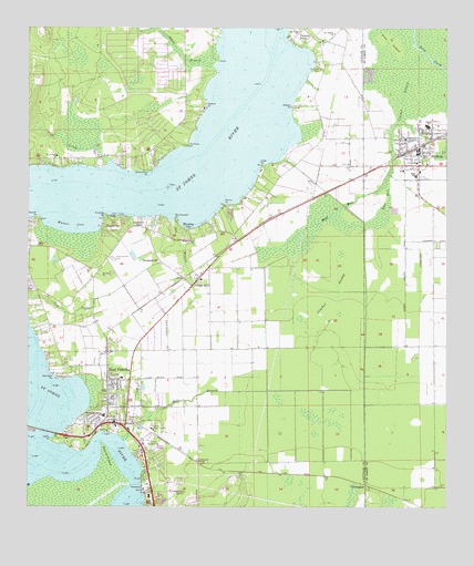
Hastings, FL USGS Topographic Map
Click on map above to begin viewing in our Map Viewer.

This topographic map contains these locations and features:
Feature Name Type Latitude Longitude GNIS ID View Map
A Hanran GrantCivilN29.6877°W81.5942°303947View Map
Azalea Mobile Home Park NorthPopulated PlaceN29.6365°W81.5867°2448791View Map
Azalea Mobile Home Park SouthPopulated PlaceN29.6358°W81.5879°2448792View Map
Bodine PointCapeN29.7297°W81.5709°279129View Map
Browning Pierce SchoolSchoolN29.6494°W81.6023°279488View Map
Carman CoveBayN29.6528°W81.6119°295025View Map
Church of God by Faith of East PalatkaChurchN29.6572°W81.6000°2448796View Map
Citadel Baptist ChurchChurchN29.6513°W81.6002°2448797View Map
Cole PointCapeN29.7144°W81.5545°280641View Map
Cracker BranchStreamN29.7436°W81.5070°307926View Map
Cracker SwampSwampN29.6831°W81.5327°280981View Map
Cypress PointPopulated PlaceN29.6980°W81.5901°295233View Map
Dancy PointCapeN29.7041°W81.5645°281275View Map
Devils ElbowBendN29.6364°W81.6013°281492View Map
Dog BranchStreamN29.7002°W81.5815°281643View Map
Earle AirparkAirportN29.6915°W81.5069°309480View Map
East Gate SquareLocaleN29.6436°W81.6073°295956View Map
East PalatkaPopulated PlaceN29.6583°W81.5984°282007View Map
East Palatka Census Designated PlaceCensusN29.6506°W81.5982°2402433View Map
East Palatka DivisionCivilN29.6393°W81.5656°1935753View Map
East Palatka Mini-MallLocaleN29.6455°W81.5942°295955View Map
East Palatka Post OfficePost OfficeN29.6513°W81.6002°2448790View Map
East Palatka Volunteer Fire DepartmentBuildingN29.6551°W81.6003°2644017View Map
East Run Cracker BranchStreamN29.7122°W81.5173°307943View Map
Elthu Woodruff GrantCivilN29.6450°W81.6084°303948View Map
FairviewPopulated PlaceN29.7214°W81.5798°300886View Map
Federal PointPopulated PlaceN29.7480°W81.5442°282404View Map
First Baptist Church of East PalatkaChurchN29.6537°W81.5997°2448798View Map
Fish CreekStreamN29.7150°W81.6009°282477View Map
Francis Richard GrantCivilN29.6994°W81.5998°303936View Map
George I F Clarke GrantCivilN29.6652°W81.5201°308373View Map
GrandviewPopulated PlaceN29.6997°W81.5995°295320View Map
Grubbs Mobile Home ClubPopulated PlaceN29.6988°W81.5860°2448793View Map
Harris SchoolSchoolN29.7247°W81.5054°307979View Map
Harts PointCapeN29.6427°W81.6181°283790View Map
HastingsPopulated PlaceN29.7180°W81.5081°307980View Map
Hastings Elementary/Middle SchoolSchoolN29.7119°W81.5090°308230View Map
Hastings Post OfficePost OfficeN29.7177°W81.5066°2448197View Map
J Summeral GrantCivilN29.6655°W81.6142°303944View Map
John Faulk GrantCivilN29.6955°W81.5784°303943View Map
John Heurtas GrantCivilN29.7002°W81.5676°303946View Map
Mason BranchStreamN29.7402°W81.5695°286502View Map
Memorial BridgeBridgeN29.6461°W81.6248°303591View Map
Middle PointCapeN29.7297°W81.5459°286808View Map
Mill BranchStreamN29.6422°W81.5956°286852View Map
Moritani PointCapeN29.6594°W81.6173°287138View Map
Mount Nebo ChurchChurchN29.6855°W81.6029°287241View Map
Mount Olive African Methodist Episcopal ChurchChurchN29.6581°W81.5999°2448799View Map
Mount Pisgah ChurchChurchN29.7483°W81.5329°287289View Map
Mount Zion ChurchChurchN29.7469°W81.5367°287345View Map
Murphys CoveBayN29.6998°W81.5759°287481View Map
Myrtlewood PointCapeN29.7008°W81.5812°287515View Map
New Life Temple FellowshipChurchN29.6513°W81.6002°2448800View Map
Orange MillsPopulated PlaceN29.6850°W81.5731°288217View Map
Orange Mills ChurchChurchN29.6947°W81.5745°288218View Map
PatersonvillePopulated PlaceN29.6889°W81.5845°295527View Map
Patersonville CemeteryLocaleN29.6897°W81.5992°288568View Map
Pine IslandIslandN29.7466°W81.5162°308081View Map
Potato Blossom Airport (historical)AirportN29.7019°W81.5065°309481View Map
Putnam Correctional InstitutionBuildingN29.6462°W81.5878°2448795View Map
Putnam County Emergency Medical Services Rescue Station 84BuildingN29.6550°W81.6003°2661731View Map
Putnam Power PlantLocaleN29.6282°W81.5854°2452095View Map
Resthaven Cemetery and Memorial ParkCemeteryN29.7127°W81.5026°308218View Map
River Road ChurchChurchN29.7166°W81.6162°289732View Map
Rivercrest Trailer ParkPopulated PlaceN29.6389°W81.5923°2451680View Map
Rollestown (historical)Populated PlaceN29.6336°W81.5998°294490View Map
Russells PointCapeN29.7136°W81.6031°303950View Map
Russels PointCapeN29.7014°W81.6017°290081View Map
Saint Johns County Public Library System Hastings Branch LibraryBuildingN29.7117°W81.5089°2448196View Map
Saint Johns County Sheriff's Office - Hastings Field OfficeBuildingN29.7116°W81.5089°2333176View Map
Saint Pauls CemeteryCemeteryN29.7400°W81.5379°290337View Map
Saint Pauls ChurchChurchN29.7491°W81.5437°290350View Map
Sarah Petty GrantCivilN29.6994°W81.5998°303945View Map
Town of HastingsCivilN29.7124°W81.5028°2406652View Map
Verdiere PointCapeN29.7194°W81.5767°292757View Map
WAJM-TV (Palatka)TowerN29.7180°W81.5176°310322View Map
Warner CoveBayN29.6990°W81.6113°292886View Map
Warner PointCapeN29.7011°W81.6217°292888View Map
Warwick Trailer ParkPopulated PlaceN29.6532°W81.5991°2448794View Map
West Run Cracker BranchStreamN29.7119°W81.5170°308171View Map
Whetstone PointCapeN29.7127°W81.5881°293177View Map
WPLK-AM (Palatka)TowerN29.6280°W81.5762°310108View Map
WPLK-AM (Palatka)TowerN29.6522°W81.5920°310109View Map
YelvingtonPopulated PlaceN29.6314°W81.5240°308179View Map

Note: Coordinates in the location and feature list above are referenced to NAD83 datum.


Copyright (C) 2008-2024 Ryan Niemi / Sunset Dynamics ... All Rights Reserved