TopoQuest Logo
Do you find TopoQuest useful?
Help keep TopoQuest running and adding new maps/features by donating!
Bitcoin:  19c7KJd3qBynnjoSw5npx9KScwjBe4ifkT
Litecoin:  LXs6TkuXGGXo1vDsWCkWVdjQX94eUKd6ui
Home View Maps Find Maps Find Places Resources & Links


Bird Island Point, Louisiana Topographic Map

USGS Map Title: Bird Island Point, LA
USGS Map MRC: 31092E1
DRG (GeoTIFF) Download: o31092e1.tif


Neighboring USGS Topographic Map Quads:


  Jena West, LA  
31092F2
 

  Jena East, LA  
31092F1
 

  Manifest, LA  
31091F8
 

  Nebo, LA  
31092E2
 

  Bird Island Point, LA  
31092E1
 

  Walters, LA  
31091E8
 

  Holloway, LA  
31092D2
 

  Buckeye NE, LA  
31092D1
 

  Larto Lake North, LA  
31091D8


Map MRC Location:

N32°
W93°
N32°
W92°
H8 H7 H6 H5 H4 H3 H2 H1
G8 G7 G6 G5 G4 G3 G2 G1
F8 F7 F6 F5 F4 F3 F2 F1
E8 E7 E6 E5 E4 E3 E2 E1
D8 D7 D6 D5 D4 D3 D2 D1
C8 C7 C6 C5 C4 C3 C2 C1
B8 B7 B6 B5 B4 B3 B2 B1
A8 A7 A6 A5 A4 A3 A2 A1
N31°
W93°
N31°
W92°

Bird Island Point, LA USGS 1:24K Topographic Map Preview:
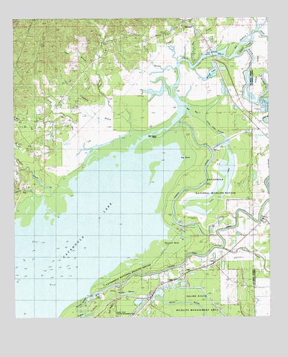
Bird Island Point, LA USGS Topographic Map
Click on map above to begin viewing in our Map Viewer.

This topographic map contains these locations and features:
Feature Name Type Latitude Longitude GNIS ID View Map
Big BayBayN31.5874°W92.0396°533018View Map
Big BendBendN31.5666°W92.0407°533032View Map
Big Bushley CreekStreamN31.6102°W92.0168°533055View Map
Bird Island PointCapeN31.5746°W92.0562°533137View Map
Browns BranchStreamN31.6071°W92.0446°545903View Map
Buck Holly BranchStreamN31.5877°W92.1071°545904View Map
Camp BayouStreamN31.5013°W92.0871°533648View Map
Catahoula LakeLakeN31.5074°W92.1211°553925View Map
Catahoula Lake Oil FieldOilfieldN31.5207°W92.1157°533820View Map
Chevallier CemeteryCemeteryN31.5416°W92.0151°533907View Map
Cowpen BayouStreamN31.5780°W92.0499°534218View Map
Crossroads Baptist ChurchChurchN31.5816°W92.1099°554140View Map
Crossroads School (historical)SchoolN31.5821°W92.1096°545913View Map
Dawes Branch School (historical)SchoolN31.6174°W92.0685°545914View Map
Devils CreekStreamN31.5474°W92.1118°554232View Map
Doyle BranchStreamN31.6043°W92.0454°558209View Map
Earl CreekStreamN31.6060°W92.0365°558212View Map
East Nebo Oil FieldOilfieldN31.5955°W92.1062°534735View Map
French Fork Oil FieldOilfieldN31.5113°W92.0751°545920View Map
Gelvin CreekStreamN31.5821°W92.0687°554520View Map
Hemphill CreekStreamN31.5516°W92.1004°554694View Map
Hickory BranchStreamN31.5824°W92.0785°535646View Map
Island BayouStreamN31.5010°W92.0910°535954View Map
Jones BranchStreamN31.6030°W92.0840°536099View Map
Little Bushley CreekStreamN31.5952°W92.0007°536501View Map
Little LakeLakeN31.5539°W92.0277°555079View Map
Little Lake SloughLakeN31.5727°W92.0241°536574View Map
Long BranchStreamN31.5527°W92.1224°536687View Map
McCure CemeteryCemeteryN31.6088°W92.0798°536976View Map
Miller CemeteryCemeteryN31.5879°W92.1104°537137View Map
Mosquito BendBendN31.5327°W92.0457°537251View Map
Mosquito Bend Oil FieldOilfieldN31.5432°W92.0429°545945View Map
Parish Governing Authority District 9CivilN31.5163°W92.0723°1930275View Map
Picket IslandIslandN31.6035°W92.0060°538115View Map
Pritchard ChurchChurchN31.5968°W92.0124°538409View Map
Prosperity Baptist ChurchChurchN31.5285°W92.0218°555732View Map
Prosperity School (historical)SchoolN31.5257°W92.0382°545962View Map
Rabbit IslandIslandN31.6132°W92.0118°538464View Map
Rhineharts Ferry (historical)CrossingN31.6099°W92.0290°545965View Map
Sandy RunStreamN31.5680°W92.0832°539172View Map
Shady Grove ChurchChurchN31.5835°W92.1237°556009View Map
Sharp TownPopulated PlaceN31.5824°W92.1137°545971View Map
Spencer CemeteryCemeteryN31.5707°W92.1173°1952105View Map
Tidwell CemeteryCemeteryN31.5710°W92.1171°556240View Map
Ward NineCivilN31.6232°W92.0985°545111View Map
WhitehallPopulated PlaceN31.6243°W92.0418°556410View Map
Willow LakeLakeN31.6016°W92.0294°556435View Map

Note: Coordinates in the location and feature list above are referenced to NAD83 datum.


Copyright (C) 2008-2024 Ryan Niemi / Sunset Dynamics ... All Rights Reserved