TopoQuest Logo
Do you find TopoQuest useful?
Help keep TopoQuest running and adding new maps/features by donating!
Bitcoin:  19c7KJd3qBynnjoSw5npx9KScwjBe4ifkT
Litecoin:  LXs6TkuXGGXo1vDsWCkWVdjQX94eUKd6ui
Home View Maps Find Maps Find Places Resources & Links


Albany East, Georgia Topographic Map

USGS Map Title: Albany East, GA
USGS Map MRC: 31084E1
DRG (GeoTIFF) Download: o31084e1.tif


Neighboring USGS Topographic Map Quads:


  Leesburg, GA  
31084F2
 

  Albany NE, GA  
31084F1
 

  Doles, GA  
31083F8
 

  Albany West, GA  
31084E2
 

  Albany East, GA  
31084E1
 

  Acree, GA  
31083E8
 

  Baconton North, GA  
31084D2
 

  Putney, GA  
31084D1
 

  Bridgeboro, GA  
31083D8


Map MRC Location:

N32°
W85°
N32°
W84°
H8 H7 H6 H5 H4 H3 H2 H1
G8 G7 G6 G5 G4 G3 G2 G1
F8 F7 F6 F5 F4 F3 F2 F1
E8 E7 E6 E5 E4 E3 E2 E1
D8 D7 D6 D5 D4 D3 D2 D1
C8 C7 C6 C5 C4 C3 C2 C1
B8 B7 B6 B5 B4 B3 B2 B1
A8 A7 A6 A5 A4 A3 A2 A1
N31°
W85°
N31°
W84°

Albany East, GA USGS 1:24K Topographic Map Preview:
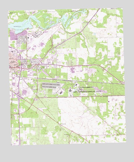
Albany East, GA USGS Topographic Map
Click on map above to begin viewing in our Map Viewer.

This topographic map contains these locations and features:
Feature Name Type Latitude Longitude GNIS ID View Map
Albany East Industrial ParkLocaleN31.5593°W84.1010°1671018View Map
Albany Fire Department Station 3BuildingN31.5172°W84.1247°2604155View Map
Albany Fire Department Station 7BuildingN31.5761°W84.0944°2604971View Map
Albany Naval Air Station (historical)MilitaryN31.5978°W84.0892°1990950View Map
Albany Police DepartmentBuildingN31.5712°W84.1053°2733813View Map
Avert AcresPopulated PlaceN31.5632°W84.0735°1671035View Map
Baker HeightsPopulated PlaceN31.5752°W84.1094°1671039View Map
Base ChapelChurchN31.5502°W84.0491°310837View Map
Berean ChurchChurchN31.5793°W84.0521°1671043View Map
BrierwoodPopulated PlaceN31.5688°W84.0860°1671049View Map
Butler SubdivisionPopulated PlaceN31.5641°W84.0780°1671052View Map
Catalina Beach EstatesPopulated PlaceN31.6066°W84.1207°1671056View Map
Church of ChristChurchN31.5405°W84.1144°1671060View Map
DosagaPopulated PlaceN31.5613°W84.1138°331575View Map
Double 'O' Farm Airport (historical)AirportN31.5349°W84.0021°326787View Map
Dougherty High SchoolSchoolN31.5671°W84.1013°1671080View Map
Dougherty Middle SchoolSchoolN31.5685°W84.1041°1671081View Map
East AlbanyPopulated PlaceN31.5757°W84.1057°331613View Map
East Dougherty DivisionCivilN31.5363°W84.0697°1936236View Map
EastgatePopulated PlaceN31.5780°W84.0807°1671084View Map
Eleanor VillagePopulated PlaceN31.5530°W84.1002°1671087View Map
First Church of the NazareneChurchN31.5105°W84.1166°1671103View Map
Five PointsPopulated PlaceN31.5749°W84.0930°331721View Map
Georgia State Patrol Troop G Post 40 AlbanyBuildingN31.5346°W84.1147°2734072View Map
Grove ParkPopulated PlaceN31.5738°W84.0869°1671126View Map
Henderson ChurchChurchN31.5746°W84.1196°315322View Map
Isabella HeightsPopulated PlaceN31.5746°W84.1177°1671143View Map
Isabella SchoolSchoolN31.5730°W84.1160°315950View Map
Jackson HeightsPopulated PlaceN31.5849°W84.1216°1671144View Map
Jackson Heights SchoolSchoolN31.5866°W84.1205°316016View Map
Junction Shopping CenterLocaleN31.5760°W84.0896°1671145View Map
Marine Corps Logistics Base AlbanyMilitaryN31.5510°W84.0519°2512429View Map
MayfairPopulated PlaceN31.5780°W84.0916°1671164View Map
Mercer Grove ChurchChurchN31.6118°W84.0382°318036View Map
Mock Road Elementary SchoolSchoolN31.5546°W84.0977°1671169View Map
Morning Star ChurchChurchN31.5435°W84.0185°318476View Map
Oak Grove Estates Mobile Home ParkPopulated PlaceN31.5502°W84.1180°1671193View Map
OakdalePopulated PlaceN31.5852°W84.0746°1671194View Map
Oglethorpe Plaza Shopping CenterLocaleN31.5693°W84.1091°1671196View Map
Paradise Village Mobile Home ParkPopulated PlaceN31.5271°W84.1207°1671201View Map
Pecan CityPopulated PlaceN31.5177°W84.0699°332630View Map
Pecan HavenPopulated PlaceN31.5738°W84.1063°1671202View Map
Pecan TerracePopulated PlaceN31.5766°W84.0774°1671203View Map
Pine Bluff ChurchChurchN31.5863°W84.0735°1671206View Map
PineviewPopulated PlaceN31.5780°W84.1085°1671209View Map
Piney Woods CreekStreamN31.6077°W84.0635°320738View Map
Piney Woods ParkParkN31.5499°W84.0077°1671210View Map
Pleasant Grove ChurchChurchN31.5077°W84.0627°320803View Map
Powell PlacePopulated PlaceN31.5724°W84.0746°1671213View Map
Radium ChurchChurchN31.5377°W84.1149°1671214View Map
Rolling GrovesPopulated PlaceN31.5966°W84.1082°1671232View Map
Ruark (historical)Populated PlaceN31.6232°W84.0371°1671233View Map
Saint Paul ChurchChurchN31.5749°W84.0832°322232View Map
Saint Stephens ChurchChurchN31.5805°W84.1241°322311View Map
SandalwoodPopulated PlaceN31.5613°W84.0746°1671238View Map
Shiloh Church (historical)ChurchN31.5135°W84.0688°1671245View Map
StromsPopulated PlaceN31.5435°W84.0941°1671254View Map
Sunnyside ChurchChurchN31.5696°W84.0938°323766View Map
SylvandalePopulated PlaceN31.5935°W84.1141°1671257View Map
Sylvandale Elementary SchoolSchoolN31.5921°W84.1127°1671258View Map
Sylvester Road Elementary SchoolSchoolN31.5727°W84.0824°1671259View Map
Tallulah Massey ParkParkN31.5702°W84.0999°323896View Map
Talulah Massey Branch LibraryBuildingN31.5705°W84.1002°1671262View Map
Tompkins VillagePopulated PlaceN31.5652°W84.0996°1671265View Map
Turner Air Force Base (historical)MilitaryN31.5978°W84.0892°1990951View Map
Turner CityPopulated PlaceN31.5980°W84.1080°333287View Map
Turner Field Municipal Golf CourseLocaleN31.6060°W84.0999°1671268View Map
Turner SchoolSchoolN31.5771°W84.0996°324417View Map
Victory ChurchChurchN31.5716°W84.0630°1671271View Map
Wesley ChapelChurchN31.5974°W84.0182°1671276View Map
Wesley ChapelChurchN31.5974°W84.0171°325007View Map
WGPC-FM (Albany)TowerN31.5493°W84.0052°352602View Map
Woodland AcresPopulated PlaceN31.5780°W84.1152°1671293View Map
WTAU-TV (Albany)TowerN31.5493°W84.0052°352830View Map

Note: Coordinates in the location and feature list above are referenced to NAD83 datum.


Copyright (C) 2008-2024 Ryan Niemi / Sunset Dynamics ... All Rights Reserved