TopoQuest Logo
Do you find TopoQuest useful?
Help keep TopoQuest running and adding new maps/features by donating!
Bitcoin:  19c7KJd3qBynnjoSw5npx9KScwjBe4ifkT
Litecoin:  LXs6TkuXGGXo1vDsWCkWVdjQX94eUKd6ui
Home View Maps Find Maps Find Places Resources & Links


Acree, Georgia Topographic Map

USGS Map Title: Acree, GA
USGS Map MRC: 31083E8
DRG (GeoTIFF) Download: o31083e8.tif


Neighboring USGS Topographic Map Quads:


  Albany NE, GA  
31084F1
 

  Doles, GA  
31083F8
 

  Cuffietown, GA  
31083F7
 

  Albany East, GA  
31084E1
 

  Acree, GA  
31083E8
 

  Sylvester, GA  
31083E7
 

  Putney, GA  
31084D1
 

  Bridgeboro, GA  
31083D8
 

  Tempy, GA  
31083D7


Map MRC Location:

N32°
W84°
N32°
W83°
H8 H7 H6 H5 H4 H3 H2 H1
G8 G7 G6 G5 G4 G3 G2 G1
F8 F7 F6 F5 F4 F3 F2 F1
E8 E7 E6 E5 E4 E3 E2 E1
D8 D7 D6 D5 D4 D3 D2 D1
C8 C7 C6 C5 C4 C3 C2 C1
B8 B7 B6 B5 B4 B3 B2 B1
A8 A7 A6 A5 A4 A3 A2 A1
N31°
W84°
N31°
W83°

Acree, GA USGS 1:24K Topographic Map Preview:
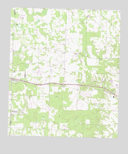
Acree, GA USGS Topographic Map
Click on map above to begin viewing in our Map Viewer.

This topographic map contains these locations and features:
Feature Name Type Latitude Longitude GNIS ID View Map
AcreePopulated PlaceN31.5555°W83.9960°310381View Map
Artesia (historical)Populated PlaceN31.5502°W83.9674°343249View Map
Aultmans Store (historical)LocaleN31.6246°W83.9449°343252View Map
Bethel CemeteryCemeteryN31.5643°W83.9516°349381View Map
Bethel ChurchChurchN31.5643°W83.9524°354592View Map
Beulah ChurchChurchN31.5207°W83.9963°311269View Map
Black LakeLakeN31.5752°W83.8907°343254View Map
Bonnie PondLakeN31.5640°W83.9722°343257View Map
Brushy PondLakeN31.5800°W83.9232°311927View Map
County Line Church (historical)ChurchN31.5077°W83.9974°1671069View Map
County Line Volunteer Fire Department Station 1BuildingN31.5223°W83.9891°2604755View Map
Crowe Airport (historical)AirportN31.6168°W83.8832°351922View Map
Deep PondLakeN31.5793°W83.9185°343273View Map
Deerfield Farm EstatesPopulated PlaceN31.5118°W83.9657°343274View Map
East DoughertyPopulated PlaceN31.5243°W83.9893°331617View Map
Evergreen School (historical)SchoolN31.5996°W83.9593°343278View Map
First Baptist ChurchChurchN31.5563°W83.9966°1671098View Map
GammagePopulated PlaceN31.5416°W83.8763°343288View Map
Gammage PondLakeN31.5682°W83.9802°343289View Map
Hill CemeteryCemeteryN31.5627°W83.9943°315410View Map
Hopewell ChurchChurchN31.5002°W83.8918°315644View Map
Hudson PondLakeN31.6089°W83.9943°315792View Map
Jackson Grove School (historical)SchoolN31.5005°W83.8918°343300View Map
Morning Star CemeteryCemeteryN31.5496°W83.9393°349391View Map
Morning Star ChurchChurchN31.5513°W83.9388°318477View Map
Morning Star School (historical)SchoolN31.5635°W83.9380°343309View Map
Mossy OaksPopulated PlaceN31.5632°W83.9805°343310View Map
Mount Holder CemeteryCemeteryN31.5960°W83.9963°1671175View Map
Mount Holder ChurchChurchN31.5971°W83.9982°318661View Map
Mount Olive ChurchChurchN31.5077°W83.9596°318733View Map
New Mount Olive ChurchChurchN31.5716°W83.9746°343315View Map
Nike Site TU-28C (historical)MilitaryN31.5544°W83.9156°1987835View Map
Nike Site TU-28L (historical)MilitaryN31.5564°W83.9053°1987836View Map
Pineknoll Country ClubLocaleN31.5557°W83.9002°344319View Map
Porters Corner School (historical)SchoolN31.5077°W83.9599°343328View Map
Red RockPopulated PlaceN31.5827°W83.9374°321409View Map
Red Rock School (historical)SchoolN31.5835°W83.9377°343330View Map
Red Rock Volunteer Fire Department Station 6BuildingN31.5832°W83.9382°2604769View Map
Rocky Branch Pond (historical)LakeN31.5749°W83.9760°343331View Map
Salem CemeteryCemeteryN31.6249°W83.9168°349407View Map
Salem Missionary Baptist ChurchChurchN31.6243°W83.9174°322348View Map
Shady Grove CemeteryCemeteryN31.6246°W83.9063°349408View Map
Shady Grove ChurchChurchN31.6243°W83.9063°322744View Map
Shady Grove School (historical)SchoolN31.6246°W83.9060°343336View Map
Sinners Friend Church (historical)ChurchN31.5993°W83.9591°343338View Map
Sowega Youth HomeBuildingN31.5543°W83.9160°343340View Map
Spring Hill ChurchChurchN31.5771°W83.8977°323416View Map
Spring Hill School (historical)SchoolN31.5771°W83.8980°343341View Map
SpringhillPopulated PlaceN31.5232°W83.9860°343342View Map
Sylvester AirportAirportN31.5558°W83.8931°351924View Map
Sylvester DivisionCivilN31.5432°W83.9018°1936572View Map
Thigpens LakeReservoirN31.5418°W83.9182°341880View Map
Thigpens Lake DamDamN31.5418°W83.9182°341879View Map
Thomas AcresPopulated PlaceN31.5355°W83.9896°343353View Map
Waving PondLakeN31.5835°W83.9146°343359View Map
Willingham (historical)Populated PlaceN31.5468°W83.9043°343362View Map
Woodcrest SubdivisionPopulated PlaceN31.5543°W83.9457°343364View Map
Yellow PondLakeN31.5624°W83.9741°343373View Map

Note: Coordinates in the location and feature list above are referenced to NAD83 datum.


Copyright (C) 2008-2025 Ryan Niemi / Sunset Dynamics ... All Rights Reserved