TopoQuest Logo
Do you find TopoQuest useful?
Help keep TopoQuest running and adding new maps/features by donating!
Bitcoin:  19c7KJd3qBynnjoSw5npx9KScwjBe4ifkT
Litecoin:  LXs6TkuXGGXo1vDsWCkWVdjQX94eUKd6ui
Home View Maps Find Maps Find Places Resources & Links


Sandstone Mountain, Arkansas Topographic Map

USGS Map Title: Sandstone Mountain, AR
USGS Map MRC: 36093C7
DRG (GeoTIFF) Download: o36093c7.tif


Neighboring USGS Topographic Map Quads:


  Garfield, AR  
36093D8
 

  Beaver, AR  
36093D7
 

  Eureka Springs, AR  
36093D6
 

  War Eagle, AR  
36093C8
 

  Sandstone Mountain, AR  
36093C7
 

  Rockhouse, AR  
36093C6
 

  Spring Valley, AR  
36093B8
 

  Hindsville, AR  
36093B7
 

  Forum, AR  
36093B6


Map MRC Location:

N37°
W94°
N37°
W93°
H8 H7 H6 H5 H4 H3 H2 H1
G8 G7 G6 G5 G4 G3 G2 G1
F8 F7 F6 F5 F4 F3 F2 F1
E8 E7 E6 E5 E4 E3 E2 E1
D8 D7 D6 D5 D4 D3 D2 D1
C8 C7 C6 C5 C4 C3 C2 C1
B8 B7 B6 B5 B4 B3 B2 B1
A8 A7 A6 A5 A4 A3 A2 A1
N36°
W94°
N36°
W93°

Sandstone Mountain, AR USGS 1:24K Topographic Map Preview:
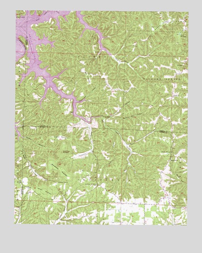
Sandstone Mountain, AR USGS Topographic Map
Click on map above to begin viewing in our Map Viewer.

This topographic map contains these locations and features:
Feature Name Type Latitude Longitude GNIS ID View Map
Beulah ChurchChurchN36.3256°W93.7602°46493View Map
Beulah Union CemeteryCemeteryN36.3251°W93.7605°1959665View Map
Bluff Field MountainSummitN36.2920°W93.8408°57400View Map
Buck MountainSummitN36.3365°W93.8219°47134View Map
Buck Mountain AirportAirportN36.3403°W93.8264°2650723View Map
Durham Mill HollowValleyN36.3131°W93.8058°48719View Map
Grindstone MountainSummitN36.3687°W93.7655°49682View Map
Hogscald HollowValleyN36.3126°W93.8113°77195View Map
Kenars MountainSummitN36.2698°W93.8535°58012View Map
Kirk HollowValleyN36.3017°W93.8721°50881View Map
Lone StarPopulated PlaceN36.3440°W93.7530°58082View Map
Long HollowValleyN36.3040°W93.8027°51426View Map
Mountain View ChurchChurchN36.2745°W93.8435°52506View Map
Mundell (historical)Populated PlaceN36.3667°W93.8669°69231View Map
North Clifty CreekStreamN36.3651°W93.8724°52812View Map
Pemberton CemeteryCemeteryN36.2892°W93.8269°53263View Map
Pemberton HollowValleyN36.3092°W93.8216°53264View Map
Penitentiary HollowValleyN36.3220°W93.8305°53268View Map
Polecat MountainSummitN36.3012°W93.8421°58407View Map
Pond MountainSummitN36.3617°W93.7571°53680View Map
Rambo CemeteryCemeteryN36.3028°W93.8744°53886View Map
RockPopulated PlaceN36.2717°W93.8663°78194View Map
Rock CemeteryCemeteryN36.2745°W93.8719°75990View Map
Rock ChurchChurchN36.2748°W93.8719°54087View Map
Samuel MountainSummitN36.2731°W93.8191°58579View Map
Sandstone MountainSummitN36.2798°W93.8388°58584View Map
Springlawn Post Office (historical)Post OfficeN36.3132°W93.8110°2572525View Map
Swain MountainSummitN36.2909°W93.7641°58720View Map
Township of CaliforniaCivilN36.2503°W93.7788°68843View Map
Township of Clifty (historical)CivilN36.3501°W93.8335°66893View Map
Township of Packard SpringsCivilN36.3446°W93.7955°66906View Map
Union Chapel (historical)ChurchN36.3617°W93.8669°69243View Map
West LibertyPopulated PlaceN36.2881°W93.7632°58854View Map
Woods HollowValleyN36.3059°W93.8744°56535View Map

Note: Coordinates in the location and feature list above are referenced to NAD83 datum.


Copyright (C) 2008-2025 Ryan Niemi / Sunset Dynamics ... All Rights Reserved