TopoQuest Logo
Do you find TopoQuest useful?
Help keep TopoQuest running and adding new maps/features by donating!
Bitcoin:  19c7KJd3qBynnjoSw5npx9KScwjBe4ifkT
Litecoin:  LXs6TkuXGGXo1vDsWCkWVdjQX94eUKd6ui
Home View Maps Find Maps Find Places Resources & Links


Forum, Arkansas Topographic Map

USGS Map Title: Forum, AR
USGS Map MRC: 36093B6
DRG (GeoTIFF) Download: o36093b6.tif


Neighboring USGS Topographic Map Quads:


  Sandstone Mountain, AR  
36093C7
 

  Rockhouse, AR  
36093C6
 

  Berryville, AR  
36093C5
 

  Hindsville, AR  
36093B7
 

  Forum, AR  
36093B6
 

  Marble, AR  
36093B5
 

  Hartwell, AR  
36093A7
 

  Huntsville, AR  
36093A6
 

  Kingston, AR  
36093A5


Map MRC Location:

N37°
W94°
N37°
W93°
H8 H7 H6 H5 H4 H3 H2 H1
G8 G7 G6 G5 G4 G3 G2 G1
F8 F7 F6 F5 F4 F3 F2 F1
E8 E7 E6 E5 E4 E3 E2 E1
D8 D7 D6 D5 D4 D3 D2 D1
C8 C7 C6 C5 C4 C3 C2 C1
B8 B7 B6 B5 B4 B3 B2 B1
A8 A7 A6 A5 A4 A3 A2 A1
N36°
W94°
N36°
W93°

Forum, AR USGS 1:24K Topographic Map Preview:
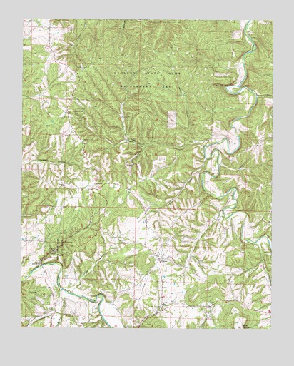
Forum, AR USGS Topographic Map
Click on map above to begin viewing in our Map Viewer.

This topographic map contains these locations and features:
Feature Name Type Latitude Longitude GNIS ID View Map
AlabamPopulated PlaceN36.1526°W93.6813°57252View Map
Alabam School (historical)SchoolN36.1334°W93.6785°66386View Map
Assembly of God ChurchChurchN36.2006°W93.7194°66387View Map
Chaplin (historical)Populated PlaceN36.2454°W93.6346°66392View Map
Dry ForkStreamN36.2190°W93.6330°48660View Map
ForumPopulated PlaceN36.1817°W93.7149°57765View Map
Forum - Alabam Volunteer Fire Department Station 1BuildingN36.1773°W93.7152°2116449View Map
Forum - Alabam Volunteer Fire Department Station 2BuildingN36.1536°W93.6812°2116450View Map
Forum Lookout TowerTowerN36.2298°W93.7202°82433View Map
Forum Post OfficePost OfficeN36.1815°W93.7146°84383View Map
Fritts CemeteryCemeteryN36.1326°W93.7341°49274View Map
Holman CreekStreamN36.1401°W93.7302°50257View Map
Jelico HollowValleyN36.2017°W93.6646°50612View Map
Lake HollowValleyN36.1931°W93.6585°50947View Map
Marshall CemeteryCemeteryN36.1828°W93.7285°51694View Map
McClain CemeteryCemeteryN36.2448°W93.6369°51788View Map
McIlroy State Game Management AreaParkN36.2334°W93.6835°51851View Map
Moody HollowValleyN36.1415°W93.7224°52146View Map
Noark CampLocaleN36.1367°W93.7427°52785View Map
Old AlabamPopulated PlaceN36.1345°W93.6796°52982View Map
Pine CreekStreamN36.1990°W93.6582°53411View Map
Postoak GapGapN36.1367°W93.6457°66408View Map
Smyrna BranchStreamN36.1301°W93.7299°78388View Map
Township of AlabamCivilN36.1874°W93.6738°68839View Map
Township of Piney (historical)CivilN36.2417°W93.6391°66407View Map
Withrow SpringsSpringN36.1562°W93.7335°56470View Map
Withrow Springs State ParkParkN36.1554°W93.7330°56471View Map

Note: Coordinates in the location and feature list above are referenced to NAD83 datum.


Copyright (C) 2008-2024 Ryan Niemi / Sunset Dynamics ... All Rights Reserved