TopoQuest Logo
Do you find TopoQuest useful?
Help keep TopoQuest running and adding new maps/features by donating!
Bitcoin:  19c7KJd3qBynnjoSw5npx9KScwjBe4ifkT
Litecoin:  LXs6TkuXGGXo1vDsWCkWVdjQX94eUKd6ui
Home View Maps Find Maps Find Places Resources & Links


Beaver, Arkansas Topographic Map

USGS Map Title: Beaver, AR
USGS Map MRC: 36093D7
DRG (GeoTIFF) Download: o36093d7.tif


Neighboring USGS Topographic Map Quads:


  Seligman, MO  
36093E8
 

  Eagle Rock, MO  
36093E7
 

  Golden, MO  
36093E6
 

  Garfield, AR  
36093D8
 

  Beaver, AR  
36093D7
 

  Eureka Springs, AR  
36093D6
 

  War Eagle, AR  
36093C8
 

  Sandstone Mountain, AR  
36093C7
 

  Rockhouse, AR  
36093C6


Map MRC Location:

N37°
W94°
N37°
W93°
H8 H7 H6 H5 H4 H3 H2 H1
G8 G7 G6 G5 G4 G3 G2 G1
F8 F7 F6 F5 F4 F3 F2 F1
E8 E7 E6 E5 E4 E3 E2 E1
D8 D7 D6 D5 D4 D3 D2 D1
C8 C7 C6 C5 C4 C3 C2 C1
B8 B7 B6 B5 B4 B3 B2 B1
A8 A7 A6 A5 A4 A3 A2 A1
N36°
W94°
N36°
W93°

Beaver, AR USGS 1:24K Topographic Map Preview:
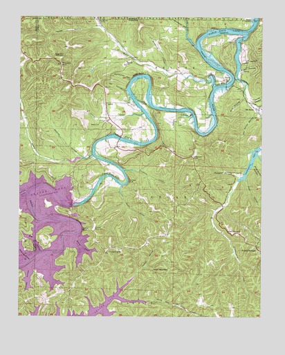
Beaver, AR USGS Topographic Map
Click on map above to begin viewing in our Map Viewer.

This topographic map contains these locations and features:
Feature Name Type Latitude Longitude GNIS ID View Map
Arkansas Game and Fish Commission Law Enforcement Northwest Regional OfficeBuildingN36.4285°W93.8441°2119016View Map
BeaverPopulated PlaceN36.4737°W93.7674°57351View Map
Beaver BridgeBridgeN36.4717°W93.7685°69190View Map
Beaver CemeteryCemeteryN36.4734°W93.7705°46261View Map
Beaver DamDamN36.4218°W93.8474°70303View Map
Beaver Dam Site ParkParkN36.4251°W93.8460°69191View Map
Beaver Post OfficePost OfficeN36.4745°W93.7690°2740123View Map
Big HollowValleyN36.4020°W93.8641°46569View Map
Blue SpringSpringN36.4645°W93.8125°46761View Map
BuschPopulated PlaceN36.4642°W93.8308°57478View Map
Busch ChurchChurchN36.4551°W93.8344°47227View Map
Busch Post OfficePost OfficeN36.4634°W93.8308°84435View Map
Butler CreekStreamN36.4709°W93.7752°47235View Map
Catron HollowValleyN36.4590°W93.7871°47530View Map
Cedar CreekStreamN36.4601°W93.8113°47584View Map
Cedar CreekStreamN36.4940°W93.7890°47587View Map
Clayborn CreekStreamN36.4359°W93.8213°47817View Map
Crane Roost BluffCliffN36.4340°W93.8260°48142View Map
Democrat HollowValleyN36.4784°W93.7994°48463View Map
Dicks CreekStreamN36.4301°W93.8219°48509View Map
Dutchman HollowValleyN36.4740°W93.8180°48721View Map
Elk RanchLocaleN36.4617°W93.7524°48853View Map
Elk Ranch HollowValleyN36.4603°W93.7530°48854View Map
Farwell Spider Creek LakeReservoirN36.4403°W93.8468°79661View Map
Farwell Spider Creek Lake DamDamN36.4417°W93.8435°79660View Map
Fuller CemeteryCemeteryN36.4417°W93.8294°49289View Map
Grassy Knob ChurchChurchN36.4020°W93.8288°49573View Map
Grassy Knob Volunteer Fire DepartmentBuildingN36.4055°W93.8341°2116497View Map
Henry HollowValleyN36.3948°W93.8121°50019View Map
Holiday Island Fire Department AmbulanceBuildingN36.4765°W93.7502°2119200View Map
Holiday Island Fire Department Station 1BuildingN36.4766°W93.7503°2116583View Map
Holiday Island Volunteer Fire Department Station 3BuildingN36.4889°W93.7754°2116585View Map
Holiday Island Volunteer Fire Department Station 4BuildingN36.4756°W93.7746°2116586View Map
Honey CreekStreamN36.4095°W93.8458°50279View Map
Huffman Ford (historical)CrossingN36.4265°W93.8708°75562View Map
Hyde HollowValleyN36.4201°W93.7502°50477View Map
Indian CreekStreamN36.4267°W93.8713°50501View Map
Inspiration PointCliffN36.4409°W93.7866°50514View Map
Inspiration Point Volunteer Fire Department Main StationBuildingN36.4429°W93.7960°2116618View Map
Inspiration Point Volunteer Fire Department SubstationBuildingN36.4711°W93.8423°2116619View Map
Lake Leatherwood DamDamN36.4451°W93.7502°79662View Map
Leatherwood CreekStreamN36.4737°W93.7610°51031View Map
Leatherwood LakeReservoirN36.4451°W93.7502°79663View Map
MacMerry SpringSpringN36.4982°W93.8349°51537View Map
Miles MountainSummitN36.4101°W93.7644°58178View Map
Mulladay HollowValleyN36.4337°W93.7607°52543View Map
Mulladay Hollow BridgeBridgeN36.4351°W93.7657°69230View Map
North Fork North Clifty CreekStreamN36.3773°W93.8335°52823View Map
Ott HollowValleyN36.4692°W93.8210°53077View Map
Panorama PointSummitN36.4806°W93.8541°53145View Map
Pine Log HollowValleyN36.3998°W93.8719°53456View Map
Pivot Rock HollowValleyN36.4376°W93.7535°53513View Map
Poddy HollowValleyN36.4962°W93.8360°53634View Map
Poker BluffCliffN36.4726°W93.7719°53651View Map
Rolloff BluffCliffN36.4112°W93.8416°54176View Map
Rolloff MountainSummitN36.4120°W93.8360°58516View Map
Salts BluffCliffN36.4767°W93.8144°54522View Map
Slickrock HollowValleyN36.4956°W93.7899°752203View Map
Smith HollowValleyN36.4651°W93.7544°54954View Map
Spider CreekStreamN36.4426°W93.8374°55068View Map
Starkey HollowValleyN36.3951°W93.8688°55171View Map
Sugar MountainSummitN36.3937°W93.7980°58707View Map
Sugarloaf MountainSummitN36.4828°W93.8546°58708View Map
Tarpin HollowValleyN36.4803°W93.7602°55437View Map
Town of BeaverCivilN36.4755°W93.7724°2405224View Map
Township of BeaverCivilN36.4733°W93.8075°66889View Map
Township of CedarCivilN36.4127°W93.7766°66892View Map
Walden (historical)Populated PlaceN36.4831°W93.8169°69245View Map
Walden CemeteryCemeteryN36.4634°W93.8155°55945View Map
Wallace BluffCliffN36.4326°W93.8180°55979View Map
Warrick HollowValleyN36.4415°W93.8427°56067View Map
Wilcox HollowValleyN36.4781°W93.7596°56351View Map
Zink HollowValleyN36.4662°W93.7591°56625View Map

Note: Coordinates in the location and feature list above are referenced to NAD83 datum.


Copyright (C) 2008-2024 Ryan Niemi / Sunset Dynamics ... All Rights Reserved