TopoQuest Logo
Do you find TopoQuest useful?
Help keep TopoQuest running and adding new maps/features by donating!
Bitcoin:  19c7KJd3qBynnjoSw5npx9KScwjBe4ifkT
Litecoin:  LXs6TkuXGGXo1vDsWCkWVdjQX94eUKd6ui
Home View Maps Find Maps Find Places Resources & Links


Sanford SW, Florida Topographic Map

USGS Map Title: Sanford SW, FL
USGS Map MRC: 28081G4
DRG (GeoTIFF) Download: o28081g4.tif


Neighboring USGS Topographic Map Quads:


  Paisley, FL  
28081H5
 

  Pine Lakes, FL  
28081H4
 

  Orange City, FL  
28081H3
 

  Sorrento, FL  
28081G5
 

  Sanford SW, FL  
28081G4
 

  Sanford, FL  
28081G3
 

  Apopka, FL  
28081F5
 

  Forest City, FL  
28081F4
 

  Casselberry, FL  
28081F3


Map MRC Location:

N29°
W82°
N29°
W81°
H8 H7 H6 H5 H4 H3 H2 H1
G8 G7 G6 G5 G4 G3 G2 G1
F8 F7 F6 F5 F4 F3 F2 F1
E8 E7 E6 E5 E4 E3 E2 E1
D8 D7 D6 D5 D4 D3 D2 D1
C8 C7 C6 C5 C4 C3 C2 C1
B8 B7 B6 B5 B4 B3 B2 B1
A8 A7 A6 A5 A4 A3 A2 A1
N28°
W82°
N28°
W81°

Sanford SW, FL USGS 1:24K Topographic Map Preview:
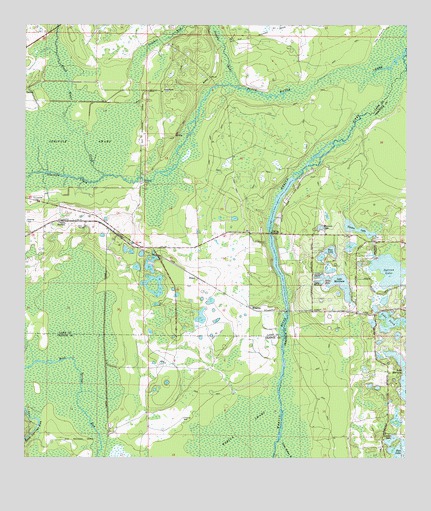
Sanford SW, FL USGS Topographic Map
Click on map above to begin viewing in our Map Viewer.

This topographic map contains these locations and features:
Feature Name Type Latitude Longitude GNIS ID View Map
Alaqua LakesPopulated PlaceN28.7578°W81.3897°2071794View Map
Black Water CreekStreamN28.8625°W81.3803°278943View Map
Black Water CreekStreamN28.8319°W81.4742°305325View Map
Cassia StationLocaleN28.8186°W81.4862°280118View Map
EthelPopulated PlaceN28.8022°W81.4434°295267View Map
Gleneagles Country ClubLocaleN28.7730°W81.4003°2448205View Map
Heathrow Elementary SchoolSchoolN28.7832°W81.3831°2480407View Map
Lake DonLakeN28.8024°W81.4006°281673View Map
Lake GaryLakeN28.8028°W81.4023°282956View Map
Lake HowardLakeN28.8013°W81.4024°284351View Map
Lake IrishLakeN28.7897°W81.3774°284590View Map
Lake MariettaLakeN28.7714°W81.3754°286427View Map
Lake MarkhamLakeN28.8003°W81.3959°286437View Map
Legacy Club at Alaqua LakesLocaleN28.7613°W81.3831°2071795View Map
Lehigh Golf and ResortLocaleN28.7514°W81.4063°2450566View Map
Linden LakeLakeN28.7554°W81.3798°285558View Map
Little Wekiva RiverStreamN28.7556°W81.4162°285849View Map
Magnolia Plantation Golf ClubLocaleN28.7758°W81.3975°2071796View Map
MarkhamPopulated PlaceN28.7930°W81.3937°301360View Map
Miranda LakeLakeN28.8168°W81.4031°286977View Map
Peter Miranda GrantCivilN28.8342°W81.4251°301031View Map
Rice LakeLakeN28.7510°W81.3773°289666View Map
Ross LakeLakeN28.8103°W81.3998°289982View Map
Seminole County Fire Department Station 36BuildingN28.7579°W81.3812°2331279View Map
Seminole County Superintendents OfficeBuildingN28.7574°W81.4075°2480075View Map
Seminole CreekStreamN28.8572°W81.4284°290833View Map
Seminole SwampSwampN28.8382°W81.4904°290847View Map
Sulphur RunStreamN28.8572°W81.4284°306461View Map
Sylvan LakeLakeN28.8045°W81.3806°291981View Map
The PrairieFlatN28.8717°W81.3842°294173View Map
Theresa Rodriquez GrantCivilN28.8442°W81.4923°303682View Map
WallingLocaleN28.8183°W81.4728°303683View Map
WekivaPopulated PlaceN28.7928°W81.4240°295701View Map
Yankee LakeLakeN28.8164°W81.3907°293562View Map

Note: Coordinates in the location and feature list above are referenced to NAD83 datum.


Copyright (C) 2008-2024 Ryan Niemi / Sunset Dynamics ... All Rights Reserved