TopoQuest Logo
Do you find TopoQuest useful?
Help keep TopoQuest running and adding new maps/features by donating!
Bitcoin:  19c7KJd3qBynnjoSw5npx9KScwjBe4ifkT
Litecoin:  LXs6TkuXGGXo1vDsWCkWVdjQX94eUKd6ui
Home View Maps Find Maps Find Places Resources & Links


Paisley, Florida Topographic Map

USGS Map Title: Paisley, FL
USGS Map MRC: 28081H5
DRG (GeoTIFF) Download: o28081h5.tif


Neighboring USGS Topographic Map Quads:


  Farles Lake, FL  
29081A6
 

  Alexander Springs, FL  
29081A5
 

  Lake Woodruff, FL  
29081A4
 

  Umatilla, FL  
28081H6
 

  Paisley, FL  
28081H5
 

  Pine Lakes, FL  
28081H4
 

  Eustis, FL  
28081G6
 

  Sorrento, FL  
28081G5
 

  Sanford SW, FL  
28081G4


Map MRC Location:

N29°
W82°
N29°
W81°
H8 H7 H6 H5 H4 H3 H2 H1
G8 G7 G6 G5 G4 G3 G2 G1
F8 F7 F6 F5 F4 F3 F2 F1
E8 E7 E6 E5 E4 E3 E2 E1
D8 D7 D6 D5 D4 D3 D2 D1
C8 C7 C6 C5 C4 C3 C2 C1
B8 B7 B6 B5 B4 B3 B2 B1
A8 A7 A6 A5 A4 A3 A2 A1
N28°
W82°
N28°
W81°

Paisley, FL USGS 1:24K Topographic Map Preview:
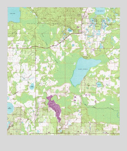
Paisley, FL USGS Topographic Map
Click on map above to begin viewing in our Map Viewer.

This topographic map contains these locations and features:
Feature Name Type Latitude Longitude GNIS ID View Map
Bass LakeLakeN28.9842°W81.5162°305238View Map
Bay LakeLakeN28.9250°W81.5229°305241View Map
Bear LakeLakeN28.9881°W81.5122°305258View Map
Black Water SwampSwampN28.9535°W81.5727°305326View Map
Blue Lakes RidgePopulated PlaceN28.9853°W81.5309°305341View Map
Camp La-No-CheLocaleN28.9514°W81.5362°305433View Map
Central Florida Bible CampLocaleN28.8808°W81.5776°306845View Map
Chain O'LakesPopulated PlaceN28.9839°W81.5117°305472View Map
Clearwater Recreation AreaParkN28.9797°W81.5548°306923View Map
Country Squire Mobile Home VillagePopulated PlaceN28.9910°W81.5386°2451656View Map
Deering Bay Yacht and Country ClubLocaleN28.8845°W81.5489°2448857View Map
First Baptist Church of PaisleyChurchN28.9900°W81.5399°2451657View Map
Gardner LakeLakeN28.9786°W81.5364°305716View Map
Johnsons CornerPopulated PlaceN28.9758°W81.5417°305879View Map
Lake - Sumter Emergency Medical Services Station 111BuildingN28.9916°W81.5399°2661870View Map
Lake AkronLakeN28.9972°W81.5223°305198View Map
Lake ClearwaterLakeN28.9778°W81.5556°305491View Map
Lake County Fire Rescue Station 13BuildingN28.9962°W81.5376°2331241View Map
Lake County Fire Rescue Station 21BuildingN28.8764°W81.5410°2331251View Map
Lake County Public Library System Paisley Branch LibraryBuildingN28.9816°W81.5427°2451655View Map
Lake DalhousieLakeN28.9018°W81.6230°305546View Map
Lake GraceLakeN28.9862°W81.5272°305742View Map
Lake JewelLakeN28.9883°W81.5274°305872View Map
Lake LuluLakeN28.9878°W81.5305°305994View Map
Lake MurphyLakeN28.9229°W81.5973°306095View Map
Lake NorrisLakeN28.9393°W81.5410°306117View Map
Lake SidneyLakeN28.9821°W81.5286°306387View Map
Lake TuttleLakeN28.8795°W81.5651°306523View Map
Mirror LakeLakeN28.9845°W81.5275°306051View Map
PaisleyPopulated PlaceN28.9836°W81.5417°306187View Map
Paisley Census Designated PlaceCensusN28.9850°W81.5404°2403387View Map
Paisley Lookout TowerTowerN28.9928°W81.5445°306188View Map
Paisley Post OfficePost OfficeN28.9825°W81.5419°2768012View Map
Paisley United Methodist ChurchChurchN28.9825°W81.5425°2451658View Map
Perch LakeSwampN28.9843°W81.5193°306213View Map
Ponceannah CemeteryCemeteryN28.9684°W81.5638°306245View Map
Silver LakeLakeN28.9872°W81.5176°306397View Map
South LakeSwampN28.9805°W81.5165°306420View Map
Trout LakeLakeN28.9827°W81.5325°306512View Map
Umatilla DivisionCivilN28.9916°W81.5415°1935957View Map

Note: Coordinates in the location and feature list above are referenced to NAD83 datum.


Copyright (C) 2008-2025 Ryan Niemi / Sunset Dynamics ... All Rights Reserved