TopoQuest Logo
Do you find TopoQuest useful?
Help keep TopoQuest running and adding new maps/features by donating!
Bitcoin:  19c7KJd3qBynnjoSw5npx9KScwjBe4ifkT
Litecoin:  LXs6TkuXGGXo1vDsWCkWVdjQX94eUKd6ui
Home View Maps Find Maps Find Places Resources & Links


Santa Fe Lake, Kansas Topographic Map

USGS Map Title: Santa Fe Lake, KS
USGS Map MRC: 37097F1
DRG (GeoTIFF) Download: o37097f1.tif


Neighboring USGS Topographic Map Quads:


  Greenwich, KS  
37097G2
 

  Benton, KS  
37097G1
 

  El Dorado SW, KS  
37096G8
 

  Andover, KS  
37097F2
 

  Santa Fe Lake, KS  
37097F1
 

  Augusta, KS  
37096F8
 

  Rose Hill, KS  
37097E2
 

  Douglass, KS  
37097E1
 

  Gordon, KS  
37096E8


Map MRC Location:

N38°
W98°
N38°
W97°
H8 H7 H6 H5 H4 H3 H2 H1
G8 G7 G6 G5 G4 G3 G2 G1
F8 F7 F6 F5 F4 F3 F2 F1
E8 E7 E6 E5 E4 E3 E2 E1
D8 D7 D6 D5 D4 D3 D2 D1
C8 C7 C6 C5 C4 C3 C2 C1
B8 B7 B6 B5 B4 B3 B2 B1
A8 A7 A6 A5 A4 A3 A2 A1
N37°
W98°
N37°
W97°

Santa Fe Lake, KS USGS 1:24K Topographic Map Preview:
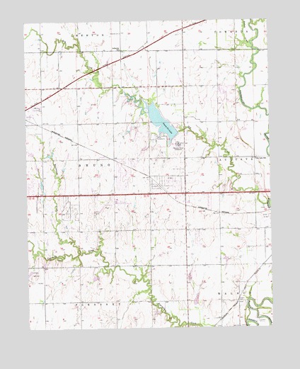
Santa Fe Lake, KS USGS Topographic Map
Click on map above to begin viewing in our Map Viewer.

This topographic map contains these locations and features:
Feature Name Type Latitude Longitude GNIS ID View Map
Andover Central Middle SchoolSchoolN37.6924°W97.1247°2497530View Map
Andover Community CenterBuildingN37.7104°W97.1235°2692569View Map
Andover Industrial ParkLocaleN37.7118°W97.1107°2692155View Map
Andover Public LibraryBuildingN37.6934°W97.1190°2694620View Map
Andover Wastewater Treatment PlantLocaleN37.6572°W97.1114°2691965View Map
Assembly of God CampgroundLocaleN37.6995°W97.0470°474239View Map
Augusta Municipal AirportAirportN37.6720°W97.0795°474238View Map
Augusta QuarryMineN37.7164°W97.0306°2726370View Map
Badger CreekStreamN37.7386°W97.0086°473884View Map
Brady-Pippin AirportAirportN37.7195°W97.0489°2675715View Map
Butler County State ParkParkN37.7097°W97.0573°474241View Map
Camp Ta Wa Ko NiLocaleN37.7020°W97.0586°474240View Map
Central Baptist ChurchChurchN37.7164°W97.0579°2689677View Map
Daniel's LandingAirportN37.6978°W97.1103°2651029View Map
Dry CreekStreamN37.6750°W97.0014°473870View Map
Fairview CemeteryCemeteryN37.6254°W97.0168°474236View Map
Golden CemeteryCemeteryN37.6359°W97.0173°474237View Map
Graham Airport (historical)AirportN37.6403°W97.1212°481264View Map
Hope Community ChurchChurchN37.7218°W97.1147°2690138View Map
Indianola (historical)LocaleN37.7383°W97.0761°481908View Map
Indianola CemeteryCemeteryN37.7450°W97.0761°474245View Map
Indianola School (historical)SchoolN37.7383°W97.0761°474244View Map
Kansas Highway Patrol Troop F ButlerBuildingN37.6783°W97.0798°2503818View Map
Lily Lake School (historical)SchoolN37.6936°W97.0075°474246View Map
LorenaPopulated PlaceN37.6939°W97.0839°484671View Map
Prairie Creek Elementary SchoolSchoolN37.6754°W97.1243°2497366View Map
Prairie Hills Southern Baptist ChurchChurchN37.6802°W97.0515°2690684View Map
Republican CreekStreamN37.6575°W97.0992°474235View Map
Santa Fe LakeReservoirN37.7094°W97.0568°474242View Map
Santa Fe Lake DamDamN37.7050°W97.0475°479864View Map
Shady Rest ParkParkN37.7214°W97.0703°474243View Map
Sills Air ParkAirportN37.6689°W97.0255°481450View Map
Township of BrunoCivilN37.6941°W97.0995°474232View Map
Trabue Airport (historical)AirportN37.6392°W97.0914°481307View Map

Note: Coordinates in the location and feature list above are referenced to NAD83 datum.


Copyright (C) 2008-2025 Ryan Niemi / Sunset Dynamics ... All Rights Reserved