TopoQuest Logo
Do you find TopoQuest useful?
Help keep TopoQuest running and adding new maps/features by donating!
Bitcoin:  19c7KJd3qBynnjoSw5npx9KScwjBe4ifkT
Litecoin:  LXs6TkuXGGXo1vDsWCkWVdjQX94eUKd6ui
Home View Maps Find Maps Find Places Resources & Links


Satterwhite, North Carolina Topographic Map

USGS Map Title: Satterwhite, NC
USGS Map MRC: 36078D6
DRG (GeoTIFF) Download: o36078d6.tif


Neighboring USGS Topographic Map Quads:


  Virgilina, VA  
36078E7
 

  Nelson, VA  
36078E6
 

  Clarksville South, VA  
36078E5
 

  Triple Springs, NC  
36078D7
 

  Satterwhite, NC  
36078D6
 

  Stovall, NC  
36078D5
 

  Moriah, NC  
36078C7
 

  Berea, NC  
36078C6
 

  Oxford, NC  
36078C5


Map MRC Location:

N37°
W79°
N37°
W78°
H8 H7 H6 H5 H4 H3 H2 H1
G8 G7 G6 G5 G4 G3 G2 G1
F8 F7 F6 F5 F4 F3 F2 F1
E8 E7 E6 E5 E4 E3 E2 E1
D8 D7 D6 D5 D4 D3 D2 D1
C8 C7 C6 C5 C4 C3 C2 C1
B8 B7 B6 B5 B4 B3 B2 B1
A8 A7 A6 A5 A4 A3 A2 A1
N36°
W79°
N36°
W78°

Satterwhite, NC USGS 1:24K Topographic Map Preview:
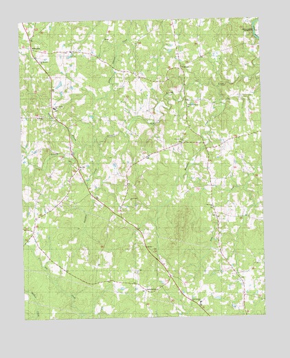
Satterwhite, NC USGS Topographic Map
Click on map above to begin viewing in our Map Viewer.

This topographic map contains these locations and features:
Feature Name Type Latitude Longitude GNIS ID View Map
Bearskin CreekStreamN36.4485°W78.7094°1023810View Map
CornwallPopulated PlaceN36.4796°W78.6653°1019793View Map
Cornwall Volunteer Fire DepartmentBuildingN36.4551°W78.6619°2638805View Map
Granville County Emergency Medical Services Station 7BuildingN36.4496°W78.7246°2720612View Map
Grassy Creek ChurchChurchN36.4646°W78.6619°985958View Map
Greenwood SchoolSchoolN36.3888°W78.6344°986131View Map
Gregory LakeReservoirN36.4468°W78.7197°1000639View Map
Gregory Lake DamDamN36.4468°W78.7197°1000638View Map
Joe Tolers SchoolSchoolN36.4629°W78.7322°987629View Map
Mount Moriah ChurchChurchN36.4601°W78.7383°1024170View Map
Mountain CreekStreamN36.4713°W78.6467°1024172View Map
Mountain Creek ChurchChurchN36.4493°W78.6656°990693View Map
Mountain Creek SchoolSchoolN36.4460°W78.6481°990694View Map
New Cornith ChurchChurchN36.4257°W78.6936°990955View Map
North Granville SchoolSchoolN36.3813°W78.6581°1007556View Map
Oak HillPopulated PlaceN36.4388°W78.7203°991418View Map
Oak Hill SchoolSchoolN36.4871°W78.7222°991421View Map
Saint Matthews ChurchChurchN36.4826°W78.7419°994067View Map
Saint Stephens ChurchChurchN36.3901°W78.7047°994138View Map
SatterwhitePopulated PlaceN36.3865°W78.6864°1022820View Map
Smyrna BranchStreamN36.4468°W78.7172°1005925View Map
Smyrna Branch SchoolSchoolN36.4565°W78.7253°995023View Map
Toler-Oak Hill SchoolSchoolN36.4638°W78.7322°1007555View Map
Township of Oak HillCivilN36.4869°W78.7256°1026715View Map
Whetstone ChurchChurchN36.4215°W78.6511°997114View Map
WilbournsPopulated PlaceN36.4890°W78.7436°1023239View Map

Note: Coordinates in the location and feature list above are referenced to NAD83 datum.


Copyright (C) 2008-2024 Ryan Niemi / Sunset Dynamics ... All Rights Reserved