TopoQuest Logo
Do you find TopoQuest useful?
Help keep TopoQuest running and adding new maps/features by donating!
Bitcoin:  19c7KJd3qBynnjoSw5npx9KScwjBe4ifkT
Litecoin:  LXs6TkuXGGXo1vDsWCkWVdjQX94eUKd6ui
Home View Maps Find Maps Find Places Resources & Links


Clarksville South, Virginia Topographic Map

USGS Map Title: Clarksville South, VA
USGS Map MRC: 36078E5
DRG (GeoTIFF) Download: o36078e5.tif


Neighboring USGS Topographic Map Quads:


  Buffalo Springs, VA  
36078F6
 

  Clarksville North, VA  
36078F5
 

  Boydton, VA  
36078F4
 

  Nelson, VA  
36078E6
 

  Clarksville South, VA  
36078E5
 

  Tungsten, NC  
36078E4
 

  Satterwhite, NC  
36078D6
 

  Stovall, NC  
36078D5
 

  Townsville, NC  
36078D4


Map MRC Location:

N37°
W79°
N37°
W78°
H8 H7 H6 H5 H4 H3 H2 H1
G8 G7 G6 G5 G4 G3 G2 G1
F8 F7 F6 F5 F4 F3 F2 F1
E8 E7 E6 E5 E4 E3 E2 E1
D8 D7 D6 D5 D4 D3 D2 D1
C8 C7 C6 C5 C4 C3 C2 C1
B8 B7 B6 B5 B4 B3 B2 B1
A8 A7 A6 A5 A4 A3 A2 A1
N36°
W79°
N36°
W78°

Clarksville South, VA USGS 1:24K Topographic Map Preview:
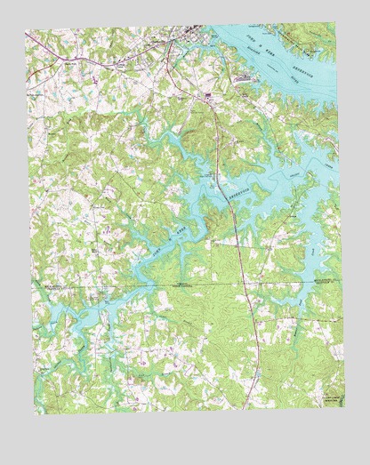
Clarksville South, VA USGS Topographic Map
Click on map above to begin viewing in our Map Viewer.

This topographic map contains these locations and features:
Feature Name Type Latitude Longitude GNIS ID View Map
Aarons Creek FarmLocaleN36.6078°W78.5964°2677663View Map
Beaver Pond CreekStreamN36.5763°W78.5064°980817View Map
Beaver Pond CreekStreamN36.5738°W78.5542°1462941View Map
Beaver Pond Creek Wildlife Management AreaParkN36.5838°W78.5694°1500607View Map
Beech CreekStreamN36.5354°W78.6164°980903View Map
Black CreekStreamN36.5529°W78.5747°1463474View Map
BlanksPopulated PlaceN36.6060°W78.5422°1500617View Map
Blue CreekStreamN36.6215°W78.5464°1463578View Map
Buckhorn BranchStreamN36.5707°W78.5267°1500629View Map
Camp ConcordLocaleN36.5640°W78.5472°1500638View Map
Cedar BranchStreamN36.5396°W78.5764°982795View Map
Chandler CemeteryCemeteryN36.5935°W78.6167°1500648View Map
ClarksvillePopulated PlaceN36.6240°W78.5569°1492773View Map
Clarksville Baptist ChurchChurchN36.6229°W78.5572°1500657View Map
Clarksville Crossing Shopping CenterLocaleN36.6215°W78.5664°1500658View Map
Clarksville Elementary SchoolSchoolN36.6017°W78.5634°1500659View Map
Clarksville MarinaLocaleN36.6190°W78.5508°1500660View Map
Clarksville Police DepartmentBuildingN36.6217°W78.5649°2767033View Map
Clarksville Presbyterian ChurchChurchN36.6240°W78.5583°1500662View Map
Clarksville Volunteer Fire DepartmentBuildingN36.6201°W78.5693°2086161View Map
Cozy CabinLocaleN36.6021°W78.5381°1465369View Map
Crowders BranchStreamN36.6174°W78.5583°1465490View Map
Distillery BranchStreamN36.6176°W78.5483°1465823View Map
Essex BranchStreamN36.5576°W78.5814°1466345View Map
Grassy CreekLocaleN36.5149°W78.6242°1023547View Map
Grassy Creek ChurchChurchN36.5143°W78.6225°985959View Map
Grassy Creek Recreation AreaParkN36.5379°W78.5961°985961View Map
HenricoPopulated PlaceN36.5926°W78.6161°1477407View Map
Hillcrest SchoolSchoolN36.6018°W78.5631°1468055View Map
Johnson CreekStreamN36.5313°W78.6061°987675View Map
Kinderton Country ClubLocaleN36.6121°W78.5494°1500733View Map
Lake Country Regional AirportAirportN36.5966°W78.5596°1498633View Map
Lewis Island (historical)IslandN36.6093°W78.5242°1500738View Map
Lewis Mill (historical)LocaleN36.5599°W78.5539°1500740View Map
Lewis Mill Dam (historical)DamN36.5599°W78.5542°1500739View Map
Lick BranchStreamN36.5565°W78.5972°1469376View Map
Lick BranchStreamN36.5785°W78.5250°1469377View Map
Lick BranchStreamN36.5174°W78.5914°988443View Map
Ligon CemeteryCemeteryN36.5587°W78.6136°1500743View Map
Little Beaver Pond CreekStreamN36.5957°W78.6089°1469469View Map
Longwood Public Use AreaParkN36.5774°W78.5511°1469852View Map
Meadow View Terrace HospiceHospitalN36.6229°W78.5776°2438441View Map
Mecklenburg County Life Saving and Rescue SquadBuildingN36.6019°W78.5550°2086133View Map
Merifield AcresPopulated PlaceN36.5938°W78.5139°1500750View Map
Merifield AirportAirportN36.5846°W78.5008°1498631View Map
Merifield Wildlife Management AreaParkN36.5874°W78.5206°1500751View Map
Mill CreekLakeN36.6209°W78.6081°1470501View Map
Mill VillagePopulated PlaceN36.6157°W78.5439°1500752View Map
Mount Ararat ChurchChurchN36.5871°W78.5411°1470806View Map
Mount Ararat School (historical)SchoolN36.5704°W78.5414°1500756View Map
Oakhurst CemeteryCemeteryN36.6190°W78.5772°1471773View Map
Old Soudan Wildlife Management AreaParkN36.5696°W78.5164°1500775View Map
Puryear CornerPopulated PlaceN36.6132°W78.5886°1477653View Map
Rattlesnake CreekStreamN36.5085°W78.6219°993052View Map
Rosseechees BluffCliffN36.6176°W78.5400°1500804View Map
Saint Timothys Episcopal ChurchChurchN36.6246°W78.5592°1500815View Map
Sandy ForkPopulated PlaceN36.6149°W78.6092°1477715View Map
Shiny RockPopulated PlaceN36.5532°W78.5972°1493584View Map
SoudanPopulated PlaceN36.5629°W78.5206°1493627View Map
Spewmarrow CreekStreamN36.5346°W78.5925°1024313View Map
State Line CemeteryCemeteryN36.5554°W78.5519°1500832View Map
State Line ChurchChurchN36.5554°W78.5514°1475088View Map
Tisdale Island (historical)IslandN36.6182°W78.5383°1500839View Map
Town of ClarksvilleCivilN36.6174°W78.5640°2390797View Map
Towns Mill Dam (historical)DamN36.6176°W78.5353°1500841View Map
Union ChapelChurchN36.5674°W78.5983°1476031View Map
Union Chapel CemeteryCemeteryN36.5676°W78.5986°1500843View Map

Note: Coordinates in the location and feature list above are referenced to NAD83 datum.


Copyright (C) 2008-2024 Ryan Niemi / Sunset Dynamics ... All Rights Reserved