TopoQuest Logo
Do you find TopoQuest useful?
Help keep TopoQuest running and adding new maps/features by donating!
Bitcoin:  19c7KJd3qBynnjoSw5npx9KScwjBe4ifkT
Litecoin:  LXs6TkuXGGXo1vDsWCkWVdjQX94eUKd6ui
Home View Maps Find Maps Find Places Resources & Links


Black Earth, Wisconsin Topographic Map

USGS Map Title: Black Earth, WI
USGS Map MRC: 43089B6
DRG (GeoTIFF) Download: o43089b6.tif


Neighboring USGS Topographic Map Quads:


  Sauk Prairie, WI  
43089C7
 

  Sauk City, WI  
43089C6
 

  Lodi, WI  
43089C5
 

  Mazomanie, WI  
43089B7
 

  Black Earth, WI  
43089B6
 

  Springfield Corners, WI  
43089B5
 

  Blue Mounds, WI  
43089A7
 

  Cross Plains, WI  
43089A6
 

  Middleton, WI  
43089A5


Map MRC Location:

N44°
W90°
N44°
W89°
H8 H7 H6 H5 H4 H3 H2 H1
G8 G7 G6 G5 G4 G3 G2 G1
F8 F7 F6 F5 F4 F3 F2 F1
E8 E7 E6 E5 E4 E3 E2 E1
D8 D7 D6 D5 D4 D3 D2 D1
C8 C7 C6 C5 C4 C3 C2 C1
B8 B7 B6 B5 B4 B3 B2 B1
A8 A7 A6 A5 A4 A3 A2 A1
N43°
W90°
N43°
W89°

Black Earth, WI USGS 1:24K Topographic Map Preview:
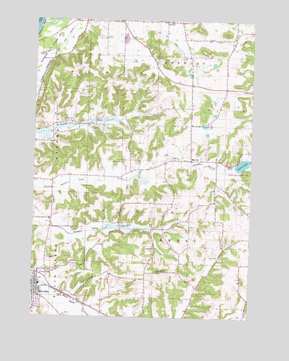
Black Earth, WI USGS Topographic Map
Click on map above to begin viewing in our Map Viewer.

This topographic map contains these locations and features:
Feature Name Type Latitude Longitude GNIS ID View Map
Aldens CornersPopulated PlaceN43.2214°W89.6401°1842307View Map
Black EarthPopulated PlaceN43.1372°W89.7468°1561861View Map
Black Earth Congregational ChurchChurchN43.1392°W89.7496°1842330View Map
Black Earth Elementary SchoolSchoolN43.1384°W89.7463°1842331View Map
Black Earth Fire DepartmentBuildingN43.1421°W89.7488°2697987View Map
Black Earth Police DepartmentBuildingN43.1379°W89.7483°2759702View Map
Dunlap CemeteryCemeteryN43.2083°W89.7289°1564183View Map
Indian LakeLakeN43.1898°W89.6300°1566917View Map
Indian Lake County ParkParkN43.1889°W89.6304°1842477View Map
MarxvillePopulated PlaceN43.1911°W89.6598°1569101View Map
Mazomanie Oak Barrens State Natural AreaParkN43.2397°W89.7404°1992461View Map
Oak Hill CemeteryCemeteryN43.1439°W89.7389°1570639View Map
Old Black Earth CemeteryCemeteryN43.1302°W89.7445°2781273View Map
RoxburyPopulated PlaceN43.2494°W89.6754°1572693View Map
Roxbury CreekStreamN43.2472°W89.7473°1572695View Map
Saint John's Lutheran Church CemeteryCemeteryN43.1541°W89.6805°2781245View Map
Saint Johns ChurchChurchN43.1539°W89.6804°1573080View Map
Saint Norbert's CemeteryCemeteryN43.2500°W89.6844°2781280View Map
Saint Paul CemeteryCemeteryN43.1914°W89.6629°2781283View Map
Sunning Hill CemeteryCemeteryN43.1903°W89.6984°1575082View Map
Table BluffCliffN43.1442°W89.6757°1575212View Map
Town of BerryCivilN43.1629°W89.6602°1582803View Map
Town of RoxburyCivilN43.2493°W89.6596°1584070View Map
Village of Black EarthCivilN43.1344°W89.7469°1582820View Map

Note: Coordinates in the location and feature list above are referenced to NAD83 datum.


Copyright (C) 2008-2025 Ryan Niemi / Sunset Dynamics ... All Rights Reserved