TopoQuest Logo
Do you find TopoQuest useful?
Help keep TopoQuest running and adding new maps/features by donating!
Bitcoin:  19c7KJd3qBynnjoSw5npx9KScwjBe4ifkT
Litecoin:  LXs6TkuXGGXo1vDsWCkWVdjQX94eUKd6ui
Home View Maps Find Maps Find Places Resources & Links


Scandia, Minnesota Topographic Map

USGS Map Title: Scandia, MN
USGS Map MRC: 45092C7
DRG (GeoTIFF) Download: o45092c7.tif


Neighboring USGS Topographic Map Quads:


  Stacy, MN  
45092D8
 

  Lindstrom, MN  
45092D7
 

  Saint Croix Dalles, WI  
45092D6
 

  Forest Lake, MN  
45092C8
 

  Scandia, MN  
45092C7
 

  Osceola, WI  
45092C6
 

  Hugo, MN  
45092B8
 

  Marine on St. Croix, MN  
45092B7
 

  Somerset North, WI  
45092B6


Map MRC Location:

N46°
W93°
N46°
W92°
H8 H7 H6 H5 H4 H3 H2 H1
G8 G7 G6 G5 G4 G3 G2 G1
F8 F7 F6 F5 F4 F3 F2 F1
E8 E7 E6 E5 E4 E3 E2 E1
D8 D7 D6 D5 D4 D3 D2 D1
C8 C7 C6 C5 C4 C3 C2 C1
B8 B7 B6 B5 B4 B3 B2 B1
A8 A7 A6 A5 A4 A3 A2 A1
N45°
W93°
N45°
W92°

Scandia, MN USGS 1:24K Topographic Map Preview:
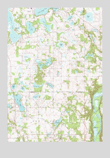
Scandia, MN USGS Topographic Map
Click on map above to begin viewing in our Map Viewer.

This topographic map contains these locations and features:
Feature Name Type Latitude Longitude GNIS ID View Map
Bloom LakeLakeN45.3662°W92.7676°640273View Map
Bone LakeLakeN45.2867°W92.8599°640362View Map
Boos LakeLakeN45.3446°W92.8306°659695View Map
Cedar BendBendN45.2891°W92.7608°1562831View Map
Chisago LakeLakeN45.3604°W92.8712°641170View Map
Chisago Lakes Golf ClubLocaleN45.3711°W92.8438°659805View Map
Chisago Lakes High SchoolSchoolN45.3745°W92.8435°2069129View Map
City of LindstromCivilN45.3643°W92.8370°2395717View Map
City of ScandiaCivilN45.2540°W92.8278°2396548View Map
Coleen LakeLakeN45.3538°W92.7596°641390View Map
Duck LakeLakeN45.3300°W92.7675°642951View Map
Elim CemeteryCemeteryN45.2532°W92.8072°659704View Map
Farmington Bottoms State Natural AreaParkN45.2619°W92.7506°2063375View Map
First LakeLakeN45.3028°W92.8192°643651View Map
Fourth LakeLakeN45.3110°W92.8590°643854View Map
Glader CemeteryCemeteryN45.3705°W92.8219°644162View Map
Goose LakeLakeN45.2682°W92.8090°644249View Map
Ice LakeLakeN45.3158°W92.7687°645325View Map
Johnson Memorial ParkCemeteryN45.2525°W92.8080°645713View Map
Kroon LakeLakeN45.3563°W92.8452°659711View Map
Linn LakeLakeN45.3596°W92.8253°646725View Map
McLeods SloughGutN45.2605°W92.7624°647706View Map
Moody LakeLakeN45.3014°W92.8671°648051View Map
Nielsen LakeLakeN45.2832°W92.8735°648551View Map
Ogren LakeLakeN45.3655°W92.7933°648905View Map
Panola German Methodist CemeteryCemeteryN45.3180°W92.7727°649138View Map
Pearson LakeLakeN45.3605°W92.7900°649214View Map
Peterson LakeLakeN45.3707°W92.7779°649330View Map
Pine LakeLakeN45.3288°W92.8498°649485View Map
Pleasant Valley OrchardLocaleN45.3531°W92.7517°2647923View Map
Rutstrum State Wildlife Management AreaParkN45.2616°W92.7605°650435View Map
Saint Francis Xavier Catholic CemeteryCemeteryN45.3147°W92.7522°2069045View Map
Saint Francis Xavier ChurchChurchN45.3150°W92.7530°650593View Map
ScandiaPopulated PlaceN45.2536°W92.8058°651258View Map
Scandia Elementary SchoolSchoolN45.2552°W92.8128°2097841View Map
Scandia Fire and Rescue DepartmentBuildingN45.2571°W92.7992°2666142View Map
Scandia Post OfficePost OfficeN45.2557°W92.8001°2097765View Map
Schlimmer PointCapeN45.3552°W92.8655°651287View Map
Sea LakeLakeN45.2919°W92.8371°651810View Map
Second LakeLakeN45.3023°W92.8361°651819View Map
Spider LakeLakeN45.3219°W92.8277°652383View Map
Swamp LakeLakeN45.3404°W92.8045°652876View Map
Third LakeLakeN45.2996°W92.8553°653133View Map
Township of Chisago LakeCivilN45.3289°W92.8363°663798View Map
Township of FranconiaCivilN45.3432°W92.7585°664214View Map
Township of New Scandia (historical)CivilN45.2522°W92.8274°665112View Map
Trulson LakeLakeN45.3480°W92.7652°653355View Map

Note: Coordinates in the location and feature list above are referenced to NAD83 datum.


Copyright (C) 2008-2025 Ryan Niemi / Sunset Dynamics ... All Rights Reserved