TopoQuest Logo
Do you find TopoQuest useful?
Help keep TopoQuest running and adding new maps/features by donating!
Bitcoin:  19c7KJd3qBynnjoSw5npx9KScwjBe4ifkT
Litecoin:  LXs6TkuXGGXo1vDsWCkWVdjQX94eUKd6ui
Home View Maps Find Maps Find Places Resources & Links


Marine on St. Croix, Minnesota Topographic Map

USGS Map Title: Marine on St. Croix, MN
USGS Map MRC: 45092B7
DRG (GeoTIFF) Download: o45092b7.tif


Neighboring USGS Topographic Map Quads:


  Forest Lake, MN  
45092C8
 

  Scandia, MN  
45092C7
 

  Osceola, WI  
45092C6
 

  Hugo, MN  
45092B8
 

  Marine on St. Croix, MN  
45092B7
 

  Somerset North, WI  
45092B6
 

  White Bear Lake East, MN  
45092A8
 

  Stillwater, MN  
45092A7
 

  Somerset South, WI  
45092A6


Map MRC Location:

N46°
W93°
N46°
W92°
H8 H7 H6 H5 H4 H3 H2 H1
G8 G7 G6 G5 G4 G3 G2 G1
F8 F7 F6 F5 F4 F3 F2 F1
E8 E7 E6 E5 E4 E3 E2 E1
D8 D7 D6 D5 D4 D3 D2 D1
C8 C7 C6 C5 C4 C3 C2 C1
B8 B7 B6 B5 B4 B3 B2 B1
A8 A7 A6 A5 A4 A3 A2 A1
N45°
W93°
N45°
W92°

Marine on St. Croix, MN USGS 1:24K Topographic Map Preview:
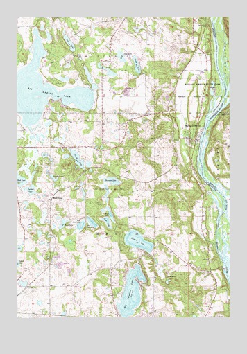
Marine on St. Croix, MN USGS Topographic Map
Click on map above to begin viewing in our Map Viewer.

This topographic map contains these locations and features:
Feature Name Type Latitude Longitude GNIS ID View Map
Amherst H Wilder Day Camp AreaLocaleN45.1761°W92.8213°639329View Map
Bass LakeLakeN45.1641°W92.8485°639672View Map
Big Carnelian LakeLakeN45.1351°W92.8086°640082View Map
Big Marine LakeLakeN45.2200°W92.8588°640103View Map
Camp KiwanisLocaleN45.1808°W92.7649°640812View Map
City of Marine on Saint CroixCivilN45.1983°W92.7783°2395007View Map
Clear LakeLakeN45.1647°W92.8225°641283View Map
CopasPopulated PlaceN45.2347°W92.7647°641487View Map
East Boot LakeLakeN45.1645°W92.8315°643048View Map
Elim CemeteryCemeteryN45.2490°W92.8128°643244View Map
Fish LakeLakeN45.2403°W92.8447°643679View Map
Greenburg IslandIslandN45.2141°W92.7560°644431View Map
Hay LakeLakeN45.2335°W92.8138°644775View Map
Keller AirportAirportN45.1362°W92.8623°660433View Map
Lake AliceReservoirN45.2202°W92.7606°659648View Map
Long LakeLakeN45.1910°W92.8396°647048View Map
Long LakeLakeN45.2269°W92.8202°647050View Map
Maple IslandPopulated PlaceN45.1741°W92.8552°654817View Map
Maple Island Post Office (historical)Post OfficeN45.1742°W92.8550°2097767View Map
Marine Elementary SchoolSchoolN45.2017°W92.7730°2433162View Map
Marine on Saint CroixPopulated PlaceN45.1981°W92.7711°647535View Map
Marine on Saint Croix Post OfficePost OfficeN45.1991°W92.7698°2097768View Map
Marine on Saint Croix Volunteer Fire DepartmentBuildingN45.1976°W92.7694°2666167View Map
Mays LakeLakeN45.1683°W92.8212°647644View Map
Mud LakeLakeN45.1825°W92.8719°648356View Map
Oakland CemeteryCemeteryN45.1987°W92.7814°648870View Map
OtisvillePopulated PlaceN45.2469°W92.7649°654865View Map
Otisville Post Office (historical)Post OfficeN45.2469°W92.7647°2097769View Map
Sand LakeLakeN45.2299°W92.8048°651148View Map
Square LakeLakeN45.1567°W92.8044°652517View Map
Staples LakeLakeN45.1832°W92.8538°652549View Map
Terrapin LakeLakeN45.1740°W92.8220°653097View Map
Township of MayCivilN45.1633°W92.8313°664932View Map
Turtle LakeLakeN45.1776°W92.8670°653375View Map
Twin LakesLakeN45.1401°W92.7866°653432View Map
West Boot LakeLakeN45.1627°W92.8381°653930View Map
William O'Brien State ParkParkN45.2194°W92.7660°654162View Map

Note: Coordinates in the location and feature list above are referenced to NAD83 datum.


Copyright (C) 2008-2025 Ryan Niemi / Sunset Dynamics ... All Rights Reserved