TopoQuest Logo
Do you find TopoQuest useful?
Help keep TopoQuest running and adding new maps/features by donating!
Bitcoin:  19c7KJd3qBynnjoSw5npx9KScwjBe4ifkT
Litecoin:  LXs6TkuXGGXo1vDsWCkWVdjQX94eUKd6ui
Home View Maps Find Maps Find Places Resources & Links


Osceola, Wisconsin Topographic Map

USGS Map Title: Osceola, WI
USGS Map MRC: 45092C6
DRG (GeoTIFF) Download: o45092c6.tif


Neighboring USGS Topographic Map Quads:


  Lindstrom, MN  
45092D7
 

  Saint Croix Dalles, WI  
45092D6
 

  Centuria, WI  
45092D5
 

  Scandia, MN  
45092C7
 

  Osceola, WI  
45092C6
 

  Nye, WI  
45092C5
 

  Marine on St. Croix, MN  
45092B7
 

  Somerset North, WI  
45092B6
 

  New Richmond North, WI  
45092B5


Map MRC Location:

N46°
W93°
N46°
W92°
H8 H7 H6 H5 H4 H3 H2 H1
G8 G7 G6 G5 G4 G3 G2 G1
F8 F7 F6 F5 F4 F3 F2 F1
E8 E7 E6 E5 E4 E3 E2 E1
D8 D7 D6 D5 D4 D3 D2 D1
C8 C7 C6 C5 C4 C3 C2 C1
B8 B7 B6 B5 B4 B3 B2 B1
A8 A7 A6 A5 A4 A3 A2 A1
N45°
W93°
N45°
W92°

Osceola, WI USGS 1:24K Topographic Map Preview:
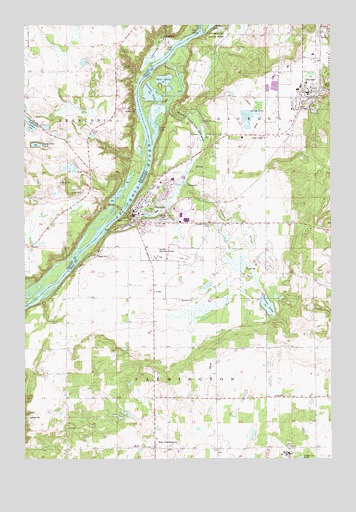
Osceola, WI USGS Topographic Map
Click on map above to begin viewing in our Map Viewer.

This topographic map contains these locations and features:
Feature Name Type Latitude Longitude GNIS ID View Map
Close SloughGutN45.3556°W92.6860°1563200View Map
Closses CreekStreamN45.3505°W92.6920°2761257View Map
DresserPopulated PlaceN45.3561°W92.6335°1564104View Map
Dresser - Osceola - Garfield Fire Association Dresser StationBuildingN45.3544°W92.6267°2696754View Map
Dresser Elementary SchoolSchoolN45.3581°W92.6349°2713189View Map
Dresser Police DepartmentBuildingN45.3555°W92.6336°2759922View Map
East FarmingtonPopulated PlaceN45.2530°W92.6974°1564317View Map
Elmgrove School (historical)SchoolN45.2680°W92.6363°1831808View Map
Farmington Center School (historical)SchoolN45.2983°W92.6983°1831809View Map
Folsom LakeLakeN45.3746°W92.6737°1565097View Map
Forest View School (historical)SchoolN45.2675°W92.6880°1831811View Map
Four-H ParkParkN45.2983°W92.6974°1581135View Map
FranconiaPopulated PlaceN45.3702°W92.6916°643878View Map
Franconia Post Office (historical)Post OfficeN45.3703°W92.6914°2068998View Map
Hawkinson LakeLakeN45.3457°W92.7415°644739View Map
Johnson LakeLakeN45.3464°W92.7476°645686View Map
Kroy-Osceola HeliportAirportN45.3200°W92.6877°1581044View Map
L O Simenstad Municipal AirportAirportN45.3099°W92.6917°1581134View Map
Lawrence CreekStreamN45.3608°W92.7013°646535View Map
Lower LakeLakeN45.3441°W92.6969°1568740View Map
Lower Saint Croix National Scenic RiverwayParkN45.3449°W92.7045°2738286View Map
OsceolaPopulated PlaceN45.3205°W92.7049°1570868View Map
Osceola Air Force Station (historical)MilitaryN45.2517°W92.6433°2089742View Map
Osceola Bedrock Glades State Natural AreaParkN45.3497°W92.6858°2063304View Map
Osceola Career Charter SchoolSchoolN45.3324°W92.6866°2713186View Map
Osceola Charter PreschoolSchoolN45.3284°W92.6957°2713408View Map
Osceola CreekStreamN45.3208°W92.7091°1570870View Map
Osceola Elementary SchoolSchoolN45.3284°W92.6955°2713405View Map
Osceola Fire and RescueBuildingN45.3217°W92.7037°2696765View Map
Osceola High SchoolSchoolN45.3324°W92.6867°2713270View Map
Osceola Intermediate SchoolSchoolN45.3307°W92.6801°2713188View Map
Osceola LakeLakeN45.2942°W92.6513°1570871View Map
Osceola Medical CenterHospitalN45.3018°W92.7003°2698472View Map
Osceola Middle SchoolSchoolN45.3306°W92.6899°2713363View Map
Osceola Police DepartmentBuildingN45.3217°W92.7039°2759559View Map
Osceola Post OfficePost OfficeN45.3205°W92.7060°2765630View Map
Osceola State Fish HatcheryLocaleN45.3461°W92.6769°1581305View Map
Peaslee LakeLakeN45.3552°W92.6986°1571134View Map
Pleasant Prairie CemeteryCemeteryN45.3175°W92.6745°1571622View Map
Ramsey CemeteryCemeteryN45.2958°W92.6870°1572053View Map
Rice LakeLakeN45.3587°W92.6929°1572259View Map
Rock IslandIslandN45.3727°W92.6777°1572450View Map
Town of FarmingtonCivilN45.2558°W92.6848°1583192View Map
TownhallLocaleN45.3114°W92.7485°659674View Map
Valley Christian SchoolSchoolN45.3448°W92.6684°2713207View Map
Village of DresserCivilN45.3618°W92.6344°1583101View Map
Village of OsceolaCivilN45.3193°W92.6936°1583874View Map

Note: Coordinates in the location and feature list above are referenced to NAD83 datum.


Copyright (C) 2008-2025 Ryan Niemi / Sunset Dynamics ... All Rights Reserved