TopoQuest Logo
Do you find TopoQuest useful?
Help keep TopoQuest running and adding new maps/features by donating!
Bitcoin:  19c7KJd3qBynnjoSw5npx9KScwjBe4ifkT
Litecoin:  LXs6TkuXGGXo1vDsWCkWVdjQX94eUKd6ui
Home View Maps Find Maps Find Places Resources & Links


Somerset North, Wisconsin Topographic Map

USGS Map Title: Somerset North, WI
USGS Map MRC: 45092B6
DRG (GeoTIFF) Download: o45092b6.tif


Neighboring USGS Topographic Map Quads:


  Scandia, MN  
45092C7
 

  Osceola, WI  
45092C6
 

  Nye, WI  
45092C5
 

  Marine on St. Croix, MN  
45092B7
 

  Somerset North, WI  
45092B6
 

  New Richmond North, WI  
45092B5
 

  Stillwater, MN  
45092A7
 

  Somerset South, WI  
45092A6
 

  New Richmond South, WI  
45092A5


Map MRC Location:

N46°
W93°
N46°
W92°
H8 H7 H6 H5 H4 H3 H2 H1
G8 G7 G6 G5 G4 G3 G2 G1
F8 F7 F6 F5 F4 F3 F2 F1
E8 E7 E6 E5 E4 E3 E2 E1
D8 D7 D6 D5 D4 D3 D2 D1
C8 C7 C6 C5 C4 C3 C2 C1
B8 B7 B6 B5 B4 B3 B2 B1
A8 A7 A6 A5 A4 A3 A2 A1
N45°
W93°
N45°
W92°

Somerset North, WI USGS 1:24K Topographic Map Preview:
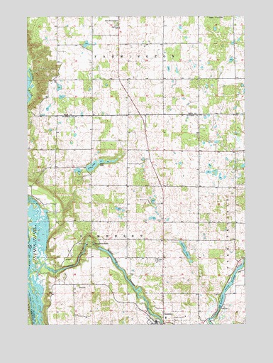
Somerset North, WI USGS Topographic Map
Click on map above to begin viewing in our Map Viewer.

This topographic map contains these locations and features:
Feature Name Type Latitude Longitude GNIS ID View Map
Apple Falls FlowageReservoirN45.1552°W92.7064°1581582View Map
Apple RiverStreamN45.1477°W92.7480°1581583View Map
Apple River Canyon State Natural AreaParkN45.1525°W92.7222°2063307View Map
Apple River FallsFallsN45.1575°W92.7121°1581584View Map
Apple River Falls D 64.5 DamDamN45.1561°W92.7091°1791712View Map
Apple River Generating StationLocaleN45.1575°W92.7161°2742137View Map
Apple River School (historical)SchoolN45.1452°W92.7141°1581813View Map
Bass LakeLakeN45.1912°W92.7080°1581590View Map
Christ Lutheran ChurchChurchN45.1255°W92.6802°1831636View Map
Country View CourtPopulated PlaceN45.1508°W92.6758°2611832View Map
Lakeside School (historical)SchoolN45.1950°W92.6799°1581819View Map
Oak Grove CemeteryCemeteryN45.2466°W92.6989°1570618View Map
Oak Knoll School (historical)SchoolN45.2247°W92.6513°1578454View Map
Oak Lawn School (historical)SchoolN45.2241°W92.7122°1578455View Map
Pine LakeLakeN45.1892°W92.7131°1581699View Map
Riverdale DamDamN45.1316°W92.6402°1791764View Map
Riverdale FlowageReservoirN45.1400°W92.6350°1581704View Map
Riverdale School (historical)SchoolN45.1477°W92.6255°1581827View Map
Saint Annes Catholic ChurchChurchN45.1277°W92.6730°1831691View Map
Saint Annes SchoolSchoolN45.1275°W92.6709°1831690View Map
Saint Croix Islands State Wildlife AreaParkN45.1589°W92.7444°1581710View Map
Sand Hill School (historical)SchoolN45.1591°W92.6719°1581828View Map
Town of SomersetCivilN45.1411°W92.7005°1584175View Map
Traisers Homestead FarmLocaleN45.1969°W92.6778°2611851View Map
Turtle LakeLakeN45.1551°W92.6599°1581747View Map
Village of SomersetCivilN45.1273°W92.6751°1584174View Map

Note: Coordinates in the location and feature list above are referenced to NAD83 datum.


Copyright (C) 2008-2025 Ryan Niemi / Sunset Dynamics ... All Rights Reserved