TopoQuest Logo
Do you find TopoQuest useful?
Help keep TopoQuest running and adding new maps/features by donating!
Bitcoin:  19c7KJd3qBynnjoSw5npx9KScwjBe4ifkT
Litecoin:  LXs6TkuXGGXo1vDsWCkWVdjQX94eUKd6ui
Home View Maps Find Maps Find Places Resources & Links


Schenevus, New York Topographic Map

USGS Map Title: Schenevus, NY
USGS Map MRC: 42074E7
DRG (GeoTIFF) Download: o42074e7.tif


Neighboring USGS Topographic Map Quads:


  Cooperstown, NY  
42074F8
 

  Westford, NY  
42074F7
 

  South Valley, NY  
42074F6
 

  Milford, NY  
42074E8
 

  Schenevus, NY  
42074E7
 

  Charlotteville, NY  
42074E6
 

  West Davenport, NY  
42074D8
 

  Davenport, NY  
42074D7
 

  Harpersfield, NY  
42074D6


Map MRC Location:

N43°
W75°
N43°
W74°
H8 H7 H6 H5 H4 H3 H2 H1
G8 G7 G6 G5 G4 G3 G2 G1
F8 F7 F6 F5 F4 F3 F2 F1
E8 E7 E6 E5 E4 E3 E2 E1
D8 D7 D6 D5 D4 D3 D2 D1
C8 C7 C6 C5 C4 C3 C2 C1
B8 B7 B6 B5 B4 B3 B2 B1
A8 A7 A6 A5 A4 A3 A2 A1
N42°
W75°
N42°
W74°

Schenevus, NY USGS 1:24K Topographic Map Preview:
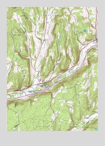
Schenevus, NY USGS Topographic Map
Click on map above to begin viewing in our Map Viewer.

This topographic map contains these locations and features:
Feature Name Type Latitude Longitude GNIS ID View Map
Badeau HillSummitN42.6162°W74.8432°942768View Map
Bliven CemeteryCemeteryN42.5173°W74.8066°944260View Map
Caryl LakeLakeN42.6009°W74.7672°945941View Map
ChasevillePopulated PlaceN42.5406°W74.8563°946442View Map
Clapper LakeLakeN42.5020°W74.7509°946731View Map
Decatur CreekStreamN42.5867°W74.7535°948158View Map
Dog HillSummitN42.5695°W74.8563°948536View Map
Elk CreekPopulated PlaceN42.5915°W74.8235°949487View Map
Elk CreekStreamN42.5442°W74.8418°949492View Map
Elk Creek CemeteryCemeteryN42.5891°W74.8261°2558773View Map
First Presbyterian ChurchChurchN42.5911°W74.7515°2597896View Map
Hooker MountainSummitN42.5981°W74.8596°953164View Map
Knapp AirportAirportN42.5939°W74.8205°2770582View Map
Little Elk CreekStreamN42.6101°W74.8174°970298View Map
Maple Grove CemeteryCemeteryN42.5953°W74.7502°956419View Map
Palmer CreekStreamN42.5620°W74.7846°959785View Map
SchenevusPopulated PlaceN42.5490°W74.8210°964574View Map
Schenevus CemeteryCemeteryN42.5498°W74.8262°2558774View Map
Schenevus Census Designated PlaceCensusN42.5497°W74.8269°2390260View Map
Schenevus Central SchoolSchoolN42.5505°W74.8190°2597177View Map
Schenevus Fire Department C H Graham Hose CompanyBuildingN42.5473°W74.8290°2718525View Map
School Number 11 (historical)SchoolN42.5476°W74.7638°974972View Map
School Number 11 (historical)SchoolN42.6109°W74.7802°974978View Map
School Number 12 (historical)SchoolN42.5248°W74.8152°975018View Map
School Number 12 (historical)SchoolN42.5247°W74.8153°2365195View Map
School Number 16 (historical)SchoolN42.5984°W74.7882°975120View Map
School Number 8 (historical)SchoolN42.6073°W74.8338°975586View Map
Second Baptist ChurchChurchN42.5915°W74.7529°2597909View Map
Seward LakeLakeN42.5396°W74.8410°964884View Map
Simpson CemeteryCemeteryN42.5129°W74.7643°965296View Map
SimpsonvillePopulated PlaceN42.5040°W74.7827°965299View Map
Smoky HollowValleyN42.5467°W74.8254°965539View Map
South HillSummitN42.5523°W74.7727°970629View Map
Sparrowhawk BrookStreamN42.5467°W74.8263°965950View Map
Sperry HollowValleyN42.5617°W74.8338°965998View Map
Town of MarylandCivilN42.5423°W74.8580°979203View Map
TuscanPopulated PlaceN42.5867°W74.7690°967990View Map
Willy's FarmLocaleN42.6028°W74.8369°2557732View Map
WorcesterPopulated PlaceN42.5915°W74.7504°971739View Map
Worcester Eastbound Rest AreaLocaleN42.5726°W74.7665°2598944View Map
Worcester Emergency SquadBuildingN42.5923°W74.7520°2720123View Map
Worcester Fire DepartmentBuildingN42.5924°W74.7520°2735176View Map

Note: Coordinates in the location and feature list above are referenced to NAD83 datum.


Copyright (C) 2008-2025 Ryan Niemi / Sunset Dynamics ... All Rights Reserved