TopoQuest Logo
Do you find TopoQuest useful?
Help keep TopoQuest running and adding new maps/features by donating!
Bitcoin:  19c7KJd3qBynnjoSw5npx9KScwjBe4ifkT
Litecoin:  LXs6TkuXGGXo1vDsWCkWVdjQX94eUKd6ui
Home View Maps Find Maps Find Places Resources & Links


Seagull Point, Michigan Topographic Map

USGS Map Title: Seagull Point, MI
USGS Map MRC: 45087E3
DRG (GeoTIFF) Download: o45087e3.tif


Neighboring USGS Topographic Map Quads:


  Wilson, MI  
45087F4
 

  Bark River, MI  
45087F3
 

  Ford River, MI  
45087F2
 

  Gourley, MI  
45087E4
 

  Seagull Point, MI  
45087E3
 

  Henderson Lakes, MI  
45087E2
 

  North Lake, MI  
45087D4
 

  Cedar River, MI  
45087D3


Map MRC Location:

N46°
W88°
N46°
W87°
H8 H7 H6 H5 H4 H3 H2 H1
G8 G7 G6 G5 G4 G3 G2 G1
F8 F7 F6 F5 F4 F3 F2 F1
E8 E7 E6 E5 E4 E3 E2 E1
D8 D7 D6 D5 D4 D3 D2 D1
C8 C7 C6 C5 C4 C3 C2 C1
B8 B7 B6 B5 B4 B3 B2 B1
A8 A7 A6 A5 A4 A3 A2 A1
N45°
W88°
N45°
W87°

Seagull Point, MI USGS 1:24K Topographic Map Preview:
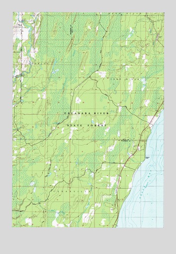
Seagull Point, MI USGS Topographic Map
Click on map above to begin viewing in our Map Viewer.

This topographic map contains these locations and features:
Feature Name Type Latitude Longitude GNIS ID View Map
Advent CreekStreamN45.6161°W87.3590°619854View Map
Advent SchoolSchoolN45.6166°W87.3679°619855View Map
Crooked CreekStreamN45.5864°W87.3746°624087View Map
Depas CreekStreamN45.6225°W87.3557°624570View Map
Gourley Township Volunteer Fire DepartmentBuildingN45.5983°W87.3682°2627079View Map
Jam Dam BridgeBridgeN45.6197°W87.3671°629198View Map
Lake ThirtysixLakeN45.5608°W87.3373°1614746View Map
Mack SpringSpringN45.5741°W87.3685°631281View Map
McCarty BridgeBridgeN45.5886°W87.3673°1623508View Map
Olson CreekStreamN45.5394°W87.2654°634044View Map
Seagull PointCapeN45.5411°W87.2668°637498View Map
Sevenmile MarshSwampN45.6080°W87.3240°637599View Map
Seventh Day Adventist Church CemeteryCemeteryN45.6161°W87.3664°2353254View Map
Seventh-Day Adventist ChurchChurchN45.6161°W87.3672°2353189View Map
West Branch Deer CreekStreamN45.5030°W87.3207°1616086View Map

Note: Coordinates in the location and feature list above are referenced to NAD83 datum.


Copyright (C) 2008-2025 Ryan Niemi / Sunset Dynamics ... All Rights Reserved