TopoQuest Logo
Do you find TopoQuest useful?
Help keep TopoQuest running and adding new maps/features by donating!
Bitcoin:  19c7KJd3qBynnjoSw5npx9KScwjBe4ifkT
Litecoin:  LXs6TkuXGGXo1vDsWCkWVdjQX94eUKd6ui
Home View Maps Find Maps Find Places Resources & Links


Ford River, Michigan Topographic Map

USGS Map Title: Ford River, MI
USGS Map MRC: 45087F2
DRG (GeoTIFF) Download: o45087f2.tif


Neighboring USGS Topographic Map Quads:


  Schaffer, MI  
45087G3
 

  Chandler, MI  
45087G2
 

  Gladstone, MI  
45087G1
 

  Bark River, MI  
45087F3
 

  Ford River, MI  
45087F2
 

  Escanaba, MI  
45087F1
 

  Seagull Point, MI  
45087E3
 

  Henderson Lakes, MI  
45087E2


Map MRC Location:

N46°
W88°
N46°
W87°
H8 H7 H6 H5 H4 H3 H2 H1
G8 G7 G6 G5 G4 G3 G2 G1
F8 F7 F6 F5 F4 F3 F2 F1
E8 E7 E6 E5 E4 E3 E2 E1
D8 D7 D6 D5 D4 D3 D2 D1
C8 C7 C6 C5 C4 C3 C2 C1
B8 B7 B6 B5 B4 B3 B2 B1
A8 A7 A6 A5 A4 A3 A2 A1
N45°
W88°
N45°
W87°

Ford River, MI USGS 1:24K Topographic Map Preview:
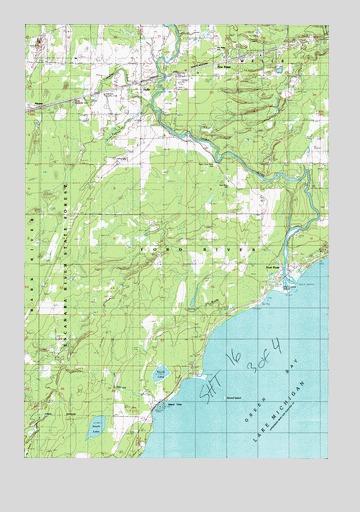
Ford River, MI USGS Topographic Map
Click on map above to begin viewing in our Map Viewer.

This topographic map contains these locations and features:
Feature Name Type Latitude Longitude GNIS ID View Map
Country Meadows Golf CourseLocaleN45.7147°W87.1306°2354296View Map
Fenlon CreekStreamN45.7269°W87.1982°625977View Map
Fivemile CreekStreamN45.7264°W87.1979°626125View Map
Ford RiverPopulated PlaceN45.6794°W87.1401°626237View Map
Ford RiverStreamN45.6722°W87.1418°626238View Map
Ford River Cemetery (historical)CemeteryN45.6819°W87.1375°2351948View Map
Ford River Community ChapelChurchN45.6592°W87.1758°2351923View Map
Ford River Post Office (historical)Post OfficeN45.6794°W87.1400°2354281View Map
Ford River School (historical)SchoolN45.7047°W87.1668°626239View Map
Ford River Station (historical)LocaleN45.6792°W87.1403°2354282View Map
Ford River Township Volunteer Fire DepartmentBuildingN45.6858°W87.1520°2627089View Map
Highland Country ClubLocaleN45.7302°W87.2176°1623411View Map
HydePopulated PlaceN45.7336°W87.2026°628902View Map
Hyde Post Office (historical)Post OfficeN45.7336°W87.2025°2354276View Map
Hyde Roadside ParkParkN45.7275°W87.2332°1618181View Map
Hyde StationLocaleN45.7336°W87.2028°2354277View Map
Island ViewPopulated PlaceN45.6394°W87.1976°629136View Map
NarentaPopulated PlaceN45.7264°W87.2426°1617734View Map
No See-um CreekStreamN45.6405°W87.1960°1618175View Map
North LakeLakeN45.6494°W87.1942°1618176View Map
Park Place of the North CampgroundLocaleN45.6783°W87.1411°2351686View Map
Pine RidgePopulated PlaceN45.7386°W87.1735°634980View Map
Pine Ridge SchoolSchoolN45.7430°W87.1712°1618178View Map
Round IslandIslandN45.6427°W87.1682°636270View Map
Saint Paul Lutheran ChurchChurchN45.7325°W87.2028°2351924View Map
South LakeLakeN45.6340°W87.2204°638377View Map
Sunny BrookGutN45.6758°W87.1810°639081View Map
Township of Ford RiverCivilN45.6609°W87.2245°1626292View Map
WBDNTowerN45.6747°W87.1418°1618177View Map
West Ford River CemeteryCemeteryN45.7091°W87.1715°1616108View Map

Note: Coordinates in the location and feature list above are referenced to NAD83 datum.


Copyright (C) 2008-2025 Ryan Niemi / Sunset Dynamics ... All Rights Reserved