TopoQuest Logo
Do you find TopoQuest useful?
Help keep TopoQuest running and adding new maps/features by donating!
Bitcoin:  19c7KJd3qBynnjoSw5npx9KScwjBe4ifkT
Litecoin:  LXs6TkuXGGXo1vDsWCkWVdjQX94eUKd6ui
Home View Maps Find Maps Find Places Resources & Links


Bark River, Michigan Topographic Map

USGS Map Title: Bark River, MI
USGS Map MRC: 45087F3
DRG (GeoTIFF) Download: o45087f3.tif


Neighboring USGS Topographic Map Quads:


  Whitney, MI  
45087G4
 

  Schaffer, MI  
45087G3
 

  Chandler, MI  
45087G2
 

  Wilson, MI  
45087F4
 

  Bark River, MI  
45087F3
 

  Ford River, MI  
45087F2
 

  Gourley, MI  
45087E4
 

  Seagull Point, MI  
45087E3
 

  Henderson Lakes, MI  
45087E2


Map MRC Location:

N46°
W88°
N46°
W87°
H8 H7 H6 H5 H4 H3 H2 H1
G8 G7 G6 G5 G4 G3 G2 G1
F8 F7 F6 F5 F4 F3 F2 F1
E8 E7 E6 E5 E4 E3 E2 E1
D8 D7 D6 D5 D4 D3 D2 D1
C8 C7 C6 C5 C4 C3 C2 C1
B8 B7 B6 B5 B4 B3 B2 B1
A8 A7 A6 A5 A4 A3 A2 A1
N45°
W88°
N45°
W87°

Bark River, MI USGS 1:24K Topographic Map Preview:
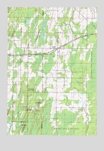
Bark River, MI USGS Topographic Map
Click on map above to begin viewing in our Map Viewer.

This topographic map contains these locations and features:
Feature Name Type Latitude Longitude GNIS ID View Map
Bark RiverPopulated PlaceN45.7102°W87.3049°620602View Map
Bark River - Harris Junior / Senior High SchoolSchoolN45.7024°W87.3446°1617092View Map
Bark River Bible ChurchChurchN45.7094°W87.3144°2351927View Map
Bark River CemeteryCemeteryN45.6855°W87.3057°620604View Map
Bark River ChurchChurchN45.6822°W87.3046°620605View Map
Bark River Post OfficePost OfficeN45.7108°W87.3041°2352323View Map
Bark River StationLocaleN45.7094°W87.3075°2351928View Map
Bark River Township Fire DepartmentBuildingN45.7035°W87.3059°2626835View Map
First LakeLakeN45.7216°W87.3258°626017View Map
HannahvillePopulated PlaceN45.6525°W87.3462°1617606View Map
Hannahville CemeteryCemeteryN45.6488°W87.3362°1617093View Map
Hannahville Indian SchoolSchoolN45.6531°W87.3472°2353190View Map
Hannahville Police DepartmentBuildingN45.6528°W87.3467°2353191View Map
Hannahville Tribal Police DepartmentBuildingN45.7024°W87.3402°2353237View Map
HarrisPopulated PlaceN45.7036°W87.3454°1617609View Map
Harris Post OfficePost OfficeN45.7029°W87.3491°2353239View Map
Harris StationLocaleN45.7042°W87.3464°2353238View Map
Harris Township Volunteer Fire Department Station 2BuildingN45.7021°W87.3673°2626913View Map
Little Pine LakeLakeN45.7352°W87.3479°630733View Map
North Branch Bark RiverStreamN45.7247°W87.2724°633488View Map
Pine CreekStreamN45.7311°W87.3232°634908View Map
Pulaski ParkParkN45.7036°W87.3226°635507View Map
Saint Elizabeth Ann Seton Catholic ChurchChurchN45.7106°W87.3092°2351925View Map
Salem Lutheran ChurchChurchN45.7028°W87.3044°2351926View Map
Second LakeLakeN45.7335°W87.3229°637523View Map
Township of Bark RiverCivilN45.7107°W87.2890°1625883View Map
Trout CreekStreamN45.6522°W87.2687°1615105View Map

Note: Coordinates in the location and feature list above are referenced to NAD83 datum.


Copyright (C) 2008-2025 Ryan Niemi / Sunset Dynamics ... All Rights Reserved