TopoQuest Logo
Do you find TopoQuest useful?
Help keep TopoQuest running and adding new maps/features by donating!
Bitcoin:  19c7KJd3qBynnjoSw5npx9KScwjBe4ifkT
Litecoin:  LXs6TkuXGGXo1vDsWCkWVdjQX94eUKd6ui
Home View Maps Find Maps Find Places Resources & Links


Secord Lake, Michigan Topographic Map

USGS Map Title: Secord Lake, MI
USGS Map MRC: 44084A3
DRG (GeoTIFF) Download: o44084a3.tif


Neighboring USGS Topographic Map Quads:


  Butman, MI  
44084B4
 

  Edwards, MI  
44084B3
 

  Sterling NW, MI  
44084B2
 

  Wagarville, MI  
44084A4
 

  Secord Lake, MI  
44084A3
 

  Sterling SW, MI  
44084A2
 

  Gladwin, MI  
43084H4
 

  Wooden Shoe Village, MI  
43084H3
 

  Bentley, MI  
43084H2


Map MRC Location:

N45°
W85°
N45°
W84°
H8 H7 H6 H5 H4 H3 H2 H1
G8 G7 G6 G5 G4 G3 G2 G1
F8 F7 F6 F5 F4 F3 F2 F1
E8 E7 E6 E5 E4 E3 E2 E1
D8 D7 D6 D5 D4 D3 D2 D1
C8 C7 C6 C5 C4 C3 C2 C1
B8 B7 B6 B5 B4 B3 B2 B1
A8 A7 A6 A5 A4 A3 A2 A1
N44°
W85°
N44°
W84°

Secord Lake, MI USGS 1:24K Topographic Map Preview:
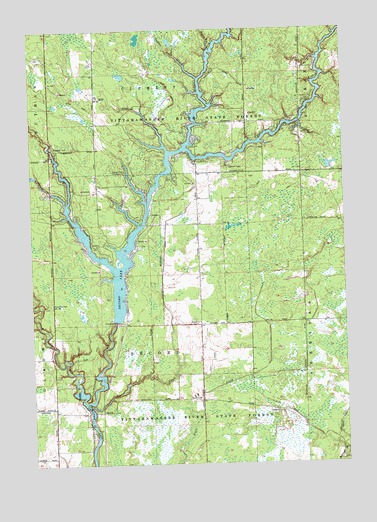
Secord Lake, MI USGS Topographic Map
Click on map above to begin viewing in our Map Viewer.

This topographic map contains these locations and features:
Feature Name Type Latitude Longitude GNIS ID View Map
Avery CreekStreamN44.1192°W84.3033°620383View Map
East Branch Tittabawassee RiverStreamN44.0906°W84.3128°625155View Map
Elk Lake CreekStreamN44.0900°W84.3206°625458View Map
Indian Lake CreekStreamN44.1109°W84.3081°629002View Map
Koll DrainCanalN44.0292°W84.3044°629847View Map
Lang DrainCanalN44.0553°W84.3231°630133View Map
Middle Branch Tittabawassee RiverStreamN44.0914°W84.3133°632241View Map
Sampson DrainCanalN44.0089°W84.3670°637152View Map
Second Lutheran CemeteryCemeteryN44.0155°W84.3550°2515975View Map
Second Post Office (historical)Post OfficeN44.0153°W84.3478°2515953View Map
SecordPopulated PlaceN44.0153°W84.3478°1617841View Map
Secord ChurchChurchN44.0409°W84.3083°637531View Map
Secord LakeReservoirN44.0417°W84.3417°637533View Map
Secord Lake CampgroundLocaleN44.0845°W84.3375°637534View Map
Secord Township Fire RescueBuildingN44.0395°W84.3383°2626909View Map
Sugar RiverStreamN44.0178°W84.3550°639024View Map
Tea CreekStreamN44.0170°W84.3536°1614640View Map
Township of ClementCivilN44.1226°W84.3278°1626095View Map
Township of SecordCivilN44.0406°W84.3275°1627056View Map
West Branch Tittabawassee RiverStreamN44.0561°W84.3419°1616080View Map
Wildwood CampgroundLocaleN44.0950°W84.2658°1616462View Map
Wildwood Fire DepartmentBuildingN44.0955°W84.2674°2627016View Map

Note: Coordinates in the location and feature list above are referenced to NAD83 datum.


Copyright (C) 2008-2025 Ryan Niemi / Sunset Dynamics ... All Rights Reserved