TopoQuest Logo
Do you find TopoQuest useful?
Help keep TopoQuest running and adding new maps/features by donating!
Bitcoin:  19c7KJd3qBynnjoSw5npx9KScwjBe4ifkT
Litecoin:  LXs6TkuXGGXo1vDsWCkWVdjQX94eUKd6ui
Home View Maps Find Maps Find Places Resources & Links


Edwards, Michigan Topographic Map

USGS Map Title: Edwards, MI
USGS Map MRC: 44084B3
DRG (GeoTIFF) Download: o44084b3.tif


Neighboring USGS Topographic Map Quads:


  Saint Helen, MI  
44084C4
 

  Ogemaw Springs, MI  
44084C3
 

  West Branch, MI  
44084C2
 

  Butman, MI  
44084B4
 

  Edwards, MI  
44084B3
 

  Sterling NW, MI  
44084B2
 

  Wagarville, MI  
44084A4
 

  Secord Lake, MI  
44084A3
 

  Sterling SW, MI  
44084A2


Map MRC Location:

N45°
W85°
N45°
W84°
H8 H7 H6 H5 H4 H3 H2 H1
G8 G7 G6 G5 G4 G3 G2 G1
F8 F7 F6 F5 F4 F3 F2 F1
E8 E7 E6 E5 E4 E3 E2 E1
D8 D7 D6 D5 D4 D3 D2 D1
C8 C7 C6 C5 C4 C3 C2 C1
B8 B7 B6 B5 B4 B3 B2 B1
A8 A7 A6 A5 A4 A3 A2 A1
N44°
W85°
N44°
W84°

Edwards, MI USGS 1:24K Topographic Map Preview:
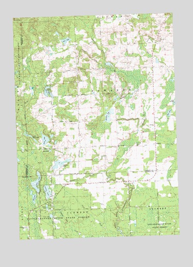
Edwards, MI USGS Topographic Map
Click on map above to begin viewing in our Map Viewer.

This topographic map contains these locations and features:
Feature Name Type Latitude Longitude GNIS ID View Map
Cedar LakeLakeN44.1379°W84.3498°622929View Map
Chatman CreekStreamN44.1614°W84.3056°623133View Map
Chatman LakeLakeN44.1672°W84.3414°623134View Map
Circle K FarmsLocaleN44.2069°W84.2653°2725294View Map
Clement Township Fire DepartmentBuildingN44.1451°W84.3521°2627038View Map
Dollar LakeLakeN44.1427°W84.3529°624761View Map
Edward Post Office (historical)Post OfficeN44.1764°W84.2667°2503041View Map
EdwardsPopulated PlaceN44.1764°W84.2667°625389View Map
Edwards CemeteryCemeteryN44.1767°W84.2828°625390View Map
Edwards ChurchChurchN44.1764°W84.3064°625391View Map
Edwards ChurchChurchN44.1872°W84.2672°625392View Map
Edwards CreekStreamN44.1856°W84.2792°625393View Map
Edwards LakeLakeN44.1907°W84.3026°625397View Map
Elk LakeLakeN44.1566°W84.3603°625455View Map
Frost LakeLakeN44.1812°W84.3529°626532View Map
Gear LakeLakeN44.2364°W84.3341°626699View Map
Indian LakeLakeN44.1518°W84.3524°628988View Map
Little Frost LakeLakeN44.1832°W84.3642°630623View Map
Mansfield CreekStreamN44.1970°W84.3003°631414View Map
Mount Zion Tabernacle ChurchChurchN44.1867°W84.2672°2501972View Map
Mud LakeLakeN44.1491°W84.3632°632985View Map
Mud LakeLakeN44.1746°W84.3491°632986View Map
Mud LakeLakeN44.1938°W84.2553°632987View Map
New Life Christian ChurchChurchN44.1875°W84.2672°2501971View Map
Oak Grove ChurchChurchN44.1306°W84.3481°633831View Map
Parren CreekStreamN44.2214°W84.3047°634426View Map
Perrys CreekStreamN44.2222°W84.3044°634683View Map
Ray CreekStreamN44.2125°W84.2517°635678View Map
Tee LakeLakeN44.2075°W84.3494°1614656View Map
Township of EdwardsCivilN44.2043°W84.3073°1626219View Map

Note: Coordinates in the location and feature list above are referenced to NAD83 datum.


Copyright (C) 2008-2025 Ryan Niemi / Sunset Dynamics ... All Rights Reserved