TopoQuest Logo
Do you find TopoQuest useful?
Help keep TopoQuest running and adding new maps/features by donating!
Bitcoin:  19c7KJd3qBynnjoSw5npx9KScwjBe4ifkT
Litecoin:  LXs6TkuXGGXo1vDsWCkWVdjQX94eUKd6ui
Home View Maps Find Maps Find Places Resources & Links


Sedalia, Virginia Topographic Map

USGS Map Title: Sedalia, VA
USGS Map MRC: 37079D4
DRG (GeoTIFF) Download: o37079d4.tif


Neighboring USGS Topographic Map Quads:


  Arnold Valley, VA  
37079E5
 

  Snowden, VA  
37079E4
 

  Big Island, VA  
37079E3
 

  Peaks of Otter, VA  
37079D5
 

  Sedalia, VA  
37079D4
 

  Boonsboro, VA  
37079D3
 

  Bedford, VA  
37079C5
 

  Goode, VA  
37079C4
 

  Forest, VA  
37079C3


Map MRC Location:

N38°
W80°
N38°
W79°
H8 H7 H6 H5 H4 H3 H2 H1
G8 G7 G6 G5 G4 G3 G2 G1
F8 F7 F6 F5 F4 F3 F2 F1
E8 E7 E6 E5 E4 E3 E2 E1
D8 D7 D6 D5 D4 D3 D2 D1
C8 C7 C6 C5 C4 C3 C2 C1
B8 B7 B6 B5 B4 B3 B2 B1
A8 A7 A6 A5 A4 A3 A2 A1
N37°
W80°
N37°
W79°

Sedalia, VA USGS 1:24K Topographic Map Preview:
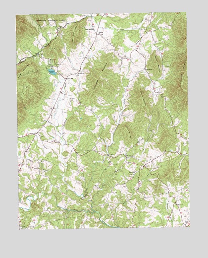
Sedalia, VA USGS Topographic Map
Click on map above to begin viewing in our Map Viewer.

This topographic map contains these locations and features:
Feature Name Type Latitude Longitude GNIS ID View Map
Bedford County Park (historical)ParkN37.4671°W79.4867°1674819View Map
Bedford LakeReservoirN37.4664°W79.4738°1481581View Map
Bedford Lake DamDamN37.4652°W79.4708°1489224View Map
Boyles BranchStreamN37.4054°W79.4673°1481963View Map
Brookhill SchoolSchoolN37.3774°W79.3789°1482026View Map
CharlemontPopulated PlaceN37.4671°W79.4050°1482454View Map
CifaxPopulated PlaceN37.4110°W79.4075°1499264View Map
Coffee CemeteryCemeteryN37.4060°W79.4142°1482615View Map
Coltons MillPopulated PlaceN37.4621°W79.4631°1482663View Map
Counter Ridge SchoolSchoolN37.4904°W79.4423°1482723View Map
CurtisPopulated PlaceN37.4768°W79.4836°1482886View Map
District 5CivilN37.4733°W79.4143°2750054View Map
Ebenezer United Methodist Church CemeteryCemeteryN37.4764°W79.4803°1674883View Map
Enenezer ChurchChurchN37.4768°W79.4814°1674840View Map
Evington Volunteer Fire DepartmentSchoolN37.3942°W79.4919°2086362View Map
Flint Stone MountainSummitN37.4887°W79.4564°1499427View Map
Grassy MountainSummitN37.4793°W79.4709°1483755View Map
Gunstock CreekStreamN37.4760°W79.4834°1483869View Map
Hurricane CreekStreamN37.4276°W79.4670°1484297View Map
Hurricane MountainSummitN37.4596°W79.4392°1484300View Map
Jackson MountainSummitN37.4510°W79.4086°1484389View Map
Kyanite Mine Waste Dam Number TwoDamN37.4935°W79.4548°1489285View Map
Lillies BranchStreamN37.4335°W79.4711°1484842View Map
Lone PineLocaleN37.4176°W79.4336°1485035View Map
Lone Pine MountainSummitN37.4293°W79.4181°1485037View Map
Mount Hermon Baptist ChurchChurchN37.4210°W79.4445°1485589View Map
Mount Rock ChurchChurchN37.4240°W79.3753°1485636View Map
Mountain Valley School (historical)SchoolN37.4468°W79.4389°1674874View Map
Nazareth ChurchChurchN37.4071°W79.4148°1485808View Map
Nelson CreekStreamN37.4918°W79.4084°1485823View Map
No Business MountainSummitN37.4701°W79.3761°1499803View Map
North Otter CreekStreamN37.3851°W79.4436°1485913View Map
Oak Grove Baptist ChurchChurchN37.3876°W79.3836°1485935View Map
Oslin CreekStreamN37.3926°W79.4509°1486007View Map
OttervillePopulated PlaceN37.4310°W79.4859°1486013View Map
Overstreet CreekStreamN37.4760°W79.4836°1486021View Map
Persimmon CreekStreamN37.4665°W79.4528°1486153View Map
Poplar Springs ChurchChurchN37.4171°W79.4211°1486359View Map
Popular Springs School (historical)SchoolN37.4174°W79.4211°1674887View Map
Roaring RunStreamN37.3754°W79.4261°1486658View Map
Saint Thomas ChurchChurchN37.4649°W79.4553°1486887View Map
Saint Thomas Episcopal Church CemeteryCemeteryN37.4647°W79.4552°1674896View Map
SedaliaPopulated PlaceN37.4876°W79.4403°1500049View Map
Squirrel MountainSummitN37.4704°W79.3975°1487499View Map
Sycamore CreekStreamN37.3890°W79.4461°1487761View Map
Turpin CemeteryCemeteryN37.4751°W79.4520°1674910View Map

Note: Coordinates in the location and feature list above are referenced to NAD83 datum.


Copyright (C) 2008-2024 Ryan Niemi / Sunset Dynamics ... All Rights Reserved