TopoQuest Logo
Do you find TopoQuest useful?
Help keep TopoQuest running and adding new maps/features by donating!
Bitcoin:  19c7KJd3qBynnjoSw5npx9KScwjBe4ifkT
Litecoin:  LXs6TkuXGGXo1vDsWCkWVdjQX94eUKd6ui
Home View Maps Find Maps Find Places Resources & Links


Boonsboro, Virginia Topographic Map

USGS Map Title: Boonsboro, VA
USGS Map MRC: 37079D3
DRG (GeoTIFF) Download: o37079d3.tif


Neighboring USGS Topographic Map Quads:


  Snowden, VA  
37079E4
 

  Big Island, VA  
37079E3
 

  Tobacco Row Mountain, VA  
37079E2
 

  Sedalia, VA  
37079D4
 

  Boonsboro, VA  
37079D3
 

  Lynchburg, VA  
37079D2
 

  Goode, VA  
37079C4
 

  Forest, VA  
37079C3
 

  City Farm, VA  
37079C2


Map MRC Location:

N38°
W80°
N38°
W79°
H8 H7 H6 H5 H4 H3 H2 H1
G8 G7 G6 G5 G4 G3 G2 G1
F8 F7 F6 F5 F4 F3 F2 F1
E8 E7 E6 E5 E4 E3 E2 E1
D8 D7 D6 D5 D4 D3 D2 D1
C8 C7 C6 C5 C4 C3 C2 C1
B8 B7 B6 B5 B4 B3 B2 B1
A8 A7 A6 A5 A4 A3 A2 A1
N37°
W80°
N37°
W79°

Boonsboro, VA USGS 1:24K Topographic Map Preview:
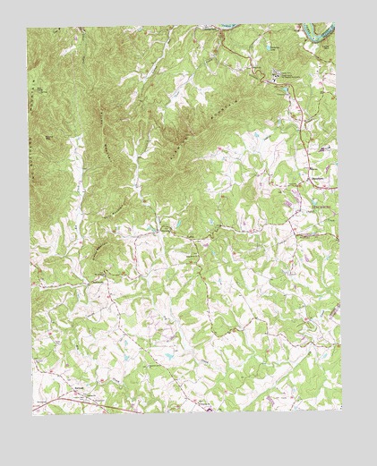
Boonsboro, VA USGS Topographic Map
Click on map above to begin viewing in our Map Viewer.

This topographic map contains these locations and features:
Feature Name Type Latitude Longitude GNIS ID View Map
Altha Grove ChurchChurchN37.4254°W79.3067°1462428View Map
Antioch ChurchChurchN37.4857°W79.2836°1462509View Map
Antioch School (historical)SchoolN37.4865°W79.2842°1674816View Map
Bear CampLocaleN37.4793°W79.3700°1462878View Map
Bethany ChurchChurchN37.3810°W79.3534°1463132View Map
BoonsboroPopulated PlaceN37.4493°W79.2614°1492610View Map
Boonsboro Country ClubLocaleN37.4599°W79.2536°1491105View Map
Boonsboro Elementary SchoolSchoolN37.4529°W79.2610°1674826View Map
Boonsboro United Methodist ChurchChurchN37.4499°W79.2625°1760454View Map
Boonsboro Volunteer Fire and Rescue Company 3BuildingN37.4507°W79.2614°2075581View Map
Chestnut Grove ChurchChurchN37.3901°W79.3281°1464814View Map
Chilarna LakeReservoirN37.4921°W79.2772°1464842View Map
CoffeePopulated PlaceN37.4310°W79.3086°1477213View Map
Colonial Hills Golf CourseLocaleN37.3793°W79.2747°1674832View Map
Cove ChurchChurchN37.4993°W79.3009°1465325View Map
Cove CreekStreamN37.4993°W79.2939°1465326View Map
Dolly MountainSummitN37.4418°W79.3359°1492872View Map
Eagle Eyrie Virginia Baptist AssemblyLocaleN37.4843°W79.2739°1466079View Map
Eagles EyriePopulated PlaceN37.4818°W79.2761°1674838View Map
Fleming MountainSummitN37.4643°W79.3084°1466693View Map
Forest Elementary SchoolSchoolN37.3757°W79.3079°2498595View Map
Grange CemeteryCemeteryN37.3790°W79.3500°1467346View Map
Grassy MountainSummitN37.4288°W79.3456°1493017View Map
Ivy Hill Airport (historical)AirportN37.3924°W79.3233°1498721View Map
Ivy Hills Golf ClubLocaleN37.4154°W79.3398°1674857View Map
Jefferson DistrictCivilN37.3877°W79.3134°1927359View Map
Jefferson Forest High SchoolSchoolN37.3761°W79.3036°2498598View Map
Locke MountainSummitN37.4921°W79.2523°1493215View Map
Meriwether School (historical)SchoolN37.4438°W79.2559°1760508View Map
Moseley School (historical)SchoolN37.3896°W79.3275°1674870View Map
Mount Carmel ChurchChurchN37.4204°W79.3448°1470846View Map
North Bedford ChurchChurchN37.4340°W79.3178°1471575View Map
North CemeteryCemeteryN37.3974°W79.3642°1471588View Map
NorwoodPopulated PlaceN37.3824°W79.3578°1477582View Map
Norwood CemeteryCemeteryN37.3924°W79.3736°1471672View Map
Norwood ChurchChurchN37.3790°W79.3689°1471673View Map
Norwood Church (historical)ChurchN37.3935°W79.3745°1674879View Map
PerrowvillePopulated PlaceN37.4176°W79.3506°1477617View Map
Ramsey DamDamN37.4518°W79.3148°1489240View Map
Rocky MountainSummitN37.4738°W79.3456°1473473View Map
Round MountainSummitN37.4640°W79.3681°1473586View Map
Saint Stephens ChurchChurchN37.3782°W79.3081°1473911View Map
Trinity ChurchChurchN37.4479°W79.2667°1475866View Map
Virginia Memorial ParkCemeteryN37.3790°W79.3534°1476200View Map
Whitten Road School (historical)SchoolN37.4129°W79.2714°1674915View Map
WYYD-FM (Amherst)TowerN37.4704°W79.3748°1498966View Map

Note: Coordinates in the location and feature list above are referenced to NAD83 datum.


Copyright (C) 2008-2024 Ryan Niemi / Sunset Dynamics ... All Rights Reserved