TopoQuest Logo
Do you find TopoQuest useful?
Help keep TopoQuest running and adding new maps/features by donating!
Bitcoin:  19c7KJd3qBynnjoSw5npx9KScwjBe4ifkT
Litecoin:  LXs6TkuXGGXo1vDsWCkWVdjQX94eUKd6ui
Home View Maps Find Maps Find Places Resources & Links


Goode, Virginia Topographic Map

USGS Map Title: Goode, VA
USGS Map MRC: 37079C4
DRG (GeoTIFF) Download: o37079c4.tif


Neighboring USGS Topographic Map Quads:


  Peaks of Otter, VA  
37079D5
 

  Sedalia, VA  
37079D4
 

  Boonsboro, VA  
37079D3
 

  Bedford, VA  
37079C5
 

  Goode, VA  
37079C4
 

  Forest, VA  
37079C3
 

  Moneta, VA  
37079B5
 

  Huddleston, VA  
37079B4
 

  Lynch Station, VA  
37079B3


Map MRC Location:

N38°
W80°
N38°
W79°
H8 H7 H6 H5 H4 H3 H2 H1
G8 G7 G6 G5 G4 G3 G2 G1
F8 F7 F6 F5 F4 F3 F2 F1
E8 E7 E6 E5 E4 E3 E2 E1
D8 D7 D6 D5 D4 D3 D2 D1
C8 C7 C6 C5 C4 C3 C2 C1
B8 B7 B6 B5 B4 B3 B2 B1
A8 A7 A6 A5 A4 A3 A2 A1
N37°
W80°
N37°
W79°

Goode, VA USGS 1:24K Topographic Map Preview:
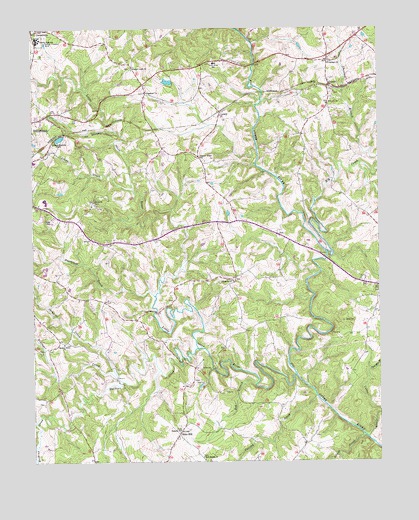
Goode, VA USGS Topographic Map
Click on map above to begin viewing in our Map Viewer.

This topographic map contains these locations and features:
Feature Name Type Latitude Longitude GNIS ID View Map
Bob BranchStreamN37.2724°W79.4198°1463621View Map
Bold Branch ChurchChurchN37.2515°W79.4389°1463641View Map
Bunker Hill CreekStreamN37.2621°W79.4989°1464097View Map
Center DistrictCivilN37.3320°W79.4925°1927136View Map
Centerpoint ChurchChurchN37.3565°W79.4584°1464679View Map
CentervillePopulated PlaceN37.3740°W79.4995°1482424View Map
Cobbs CreekStreamN37.2568°W79.3792°1465027View Map
District 7CivilN37.3704°W79.4931°2750056View Map
Elk CreekStreamN37.3104°W79.3934°1466215View Map
Ephesus ChurchChurchN37.2593°W79.4470°1466327View Map
Falling CreekStreamN37.2688°W79.3978°1466452View Map
GoodePopulated PlaceN37.3588°W79.3917°1494960View Map
Goode ChurchChurchN37.3535°W79.3920°1467219View Map
Goode Post OfficePost OfficeN37.3671°W79.3915°2766217View Map
Goode Volunteer Rescue SquadBuildingN37.3674°W79.3900°2075574View Map
Hawk Ridge AirportAirportN37.2895°W79.4466°2675592View Map
Hickory Grove ChurchChurchN37.2840°W79.4886°1467983View Map
Island CreekStreamN37.2571°W79.3803°1468532View Map
Johns CreekStreamN37.3288°W79.4631°1478858View Map
Liberty High SchoolSchoolN37.3717°W79.4978°1469374View Map
Little Otter RiverStreamN37.2749°W79.4050°1484949View Map
LowryPopulated PlaceN37.3507°W79.4309°1495047View Map
Lowry Post OfficePost OfficeN37.3498°W79.4321°2766241View Map
Machine CreekStreamN37.2826°W79.4400°1469987View Map
Markham DamDamN37.3601°W79.4498°1489228View Map
Markham PondReservoirN37.3596°W79.4507°1489229View Map
Miller AirportAirportN37.3277°W79.4043°2675591View Map
Nicopolis ChurchChurchN37.3021°W79.4278°1471545View Map
Nininger CreekStreamN37.2826°W79.4400°1471551View Map
Oak Mountain BranchStreamN37.2763°W79.3786°1471761View Map
Oakland ChurchChurchN37.3649°W79.3923°1471780View Map
Otter HillPopulated PlaceN37.2579°W79.4478°1495084View Map
Otter River Elementary SchoolSchoolN37.3650°W79.4337°1471967View Map
Poorhouse CreekStreamN37.2979°W79.4556°1472616View Map
Shiloh ChurchChurchN37.3251°W79.4775°1474509View Map
Skinnels CreekStreamN37.2749°W79.4695°1474652View Map
Timber Ridge ChurchChurchN37.3379°W79.4384°1475725View Map
Wells CreekStreamN37.2551°W79.4984°1476445View Map
Western Light ChurchChurchN37.3632°W79.4631°1476518View Map
Western Light School (historical)SchoolN37.3632°W79.4634°1674914View Map
Windy Ridge Airport (historical)AirportN37.2693°W79.4359°1498589View Map

Note: Coordinates in the location and feature list above are referenced to NAD83 datum.


Copyright (C) 2008-2025 Ryan Niemi / Sunset Dynamics ... All Rights Reserved