TopoQuest Logo
Do you find TopoQuest useful?
Help keep TopoQuest running and adding new maps/features by donating!
Bitcoin:  19c7KJd3qBynnjoSw5npx9KScwjBe4ifkT
Litecoin:  LXs6TkuXGGXo1vDsWCkWVdjQX94eUKd6ui
Home View Maps Find Maps Find Places Resources & Links


Seeley Creek, New York Topographic Map

USGS Map Title: Seeley Creek, NY
USGS Map MRC: 42076A8
DRG (GeoTIFF) Download: o42076a8.tif


Neighboring USGS Topographic Map Quads:


  Corning, NY  
42077B1
 

  Big Flats, NY  
42076B8
 

  Horseheads, NY  
42076B7
 

  Caton, NY  
42077A1
 

  Seeley Creek, NY  
42076A8
 

  Elmira, NY  
42076A7
 

  Jackson Summit, PA  
41077H1
 

  Millerton, PA  
41076H8
 

  Gillett, PA  
41076H7


Map MRC Location:

N43°
W77°
N43°
W76°
H8 H7 H6 H5 H4 H3 H2 H1
G8 G7 G6 G5 G4 G3 G2 G1
F8 F7 F6 F5 F4 F3 F2 F1
E8 E7 E6 E5 E4 E3 E2 E1
D8 D7 D6 D5 D4 D3 D2 D1
C8 C7 C6 C5 C4 C3 C2 C1
B8 B7 B6 B5 B4 B3 B2 B1
A8 A7 A6 A5 A4 A3 A2 A1
N42°
W77°
N42°
W76°

Seeley Creek, NY USGS 1:24K Topographic Map Preview:
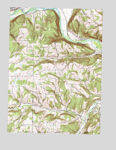
Seeley Creek, NY USGS Topographic Map
Click on map above to begin viewing in our Map Viewer.

This topographic map contains these locations and features:
Feature Name Type Latitude Longitude GNIS ID View Map
Birch CreekStreamN42.0276°W76.9741°943994View Map
Bird CreekStreamN42.0320°W76.8802°944021View Map
Central Baptist ChurchChurchN42.1224°W76.9983°2598006View Map
Clark HollowValleyN42.0235°W76.9217°946764View Map
Cleveland HillSummitN42.0698°W76.9452°946852View Map
Connelly Field (historical)AirportN42.0851°W76.9208°978005View Map
Dutch HillSummitN42.0690°W76.9289°948850View Map
Dutch Hill CemeteryCemeteryN42.0675°W76.9211°948857View Map
East Corning Fire DepartmentBuildingN42.1239°W76.9929°2701282View Map
East HillSummitN42.0631°W76.9744°949108View Map
Elmira Drive-InLocaleN42.0953°W76.9086°2514429View Map
Gillette CreekStreamN42.1190°W76.9805°970165View Map
Golden Glow Volunteer Fire Company Station 1BuildingN42.0821°W76.8813°2700876View Map
Golden Glow Volunteer Fire Company Station 2BuildingN42.0978°W76.9088°2734827View Map
Hammond CreekStreamN42.0004°W76.9030°1192043View Map
Harris HillSummitN42.1037°W76.8961°952269View Map
Harris Hill GliderportAirportN42.1209°W76.9005°978006View Map
Harris Hill ManorPopulated PlaceN42.0956°W76.9033°952271View Map
Kelly HillSummitN42.0023°W76.9800°954475View Map
Kelly Hill CemeteryCemeteryN42.0078°W76.9783°954476View Map
Kings Way Christian AcademySchoolN42.1224°W76.9984°2597621View Map
Kinner HillSummitN42.0101°W76.9450°954694View Map
Leach HillSummitN42.0867°W76.9022°955135View Map
Mount Saviour MonasteryChurchN42.0901°W76.9380°957908View Map
Mount ZoarSummitN42.0679°W76.8947°971890View Map
Mudlick CreekStreamN42.0134°W76.8961°958127View Map
National Soaring MuseumBuildingN42.1218°W76.9012°2598554View Map
Rosar HillSummitN42.0409°W76.9452°962891View Map
SagetownPopulated PlaceN42.0267°W76.9572°973034View Map
Sagetown CemeteryCemeteryN42.0285°W76.9554°2514416View Map
Seeley CreekPopulated PlaceN42.0145°W76.8925°964799View Map
Seeley Creek BridgeBridgeN42.0334°W76.8771°2598547View Map
Sing Sing CreekStreamN42.0965°W76.9202°969303View Map
Stanley Woods CampLocaleN42.0862°W76.8808°966224View Map
Steege HillSummitN42.1048°W76.9436°966322View Map
Town of SouthportCivilN42.0400°W76.8775°979509View Map
Webb MillsPopulated PlaceN42.0237°W76.8813°968976View Map
Webbs Mills Volunteer Fire Department Station 1BuildingN42.0146°W76.8936°2735113View Map
Webbs Mills Volunteer Fire Department Station 2BuildingN42.0423°W76.9505°2735114View Map
Widger HillSummitN42.0126°W76.9575°971223View Map

Note: Coordinates in the location and feature list above are referenced to NAD83 datum.


Copyright (C) 2008-2024 Ryan Niemi / Sunset Dynamics ... All Rights Reserved