TopoQuest Logo
Do you find TopoQuest useful?
Help keep TopoQuest running and adding new maps/features by donating!
Bitcoin:  19c7KJd3qBynnjoSw5npx9KScwjBe4ifkT
Litecoin:  LXs6TkuXGGXo1vDsWCkWVdjQX94eUKd6ui
Home View Maps Find Maps Find Places Resources & Links


Gillett, Pennsylvania Topographic Map

USGS Map Title: Gillett, PA
USGS Map MRC: 41076H7
DRG (GeoTIFF) Download: o41076h7.tif


Neighboring USGS Topographic Map Quads:


  Seeley Creek, NY  
42076A8
 

  Elmira, NY  
42076A7
 

  Wellsburg, NY  
42076A6
 

  Millerton, PA  
41076H8
 

  Gillett, PA  
41076H7
 

  Bentley Creek, PA  
41076H6
 

  Roseville, PA  
41076G8
 

  Troy, PA  
41076G7
 

  East Troy, PA  
41076G6


Map MRC Location:

N42°
W77°
N42°
W76°
H8 H7 H6 H5 H4 H3 H2 H1
G8 G7 G6 G5 G4 G3 G2 G1
F8 F7 F6 F5 F4 F3 F2 F1
E8 E7 E6 E5 E4 E3 E2 E1
D8 D7 D6 D5 D4 D3 D2 D1
C8 C7 C6 C5 C4 C3 C2 C1
B8 B7 B6 B5 B4 B3 B2 B1
A8 A7 A6 A5 A4 A3 A2 A1
N41°
W77°
N41°
W76°

Gillett, PA USGS 1:24K Topographic Map Preview:
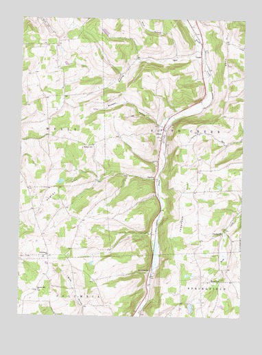
Gillett, PA USGS Topographic Map
Click on map above to begin viewing in our Map Viewer.

This topographic map contains these locations and features:
Feature Name Type Latitude Longitude GNIS ID View Map
Baker HillSummitN41.9456°W76.8394°1168598View Map
Baptist Hill CemeteryCemeteryN41.8853°W76.8639°2776402View Map
Baptist Hill ChurchChurchN41.8859°W76.8641°1168690View Map
BerrytownPopulated PlaceN41.8901°W76.7669°1203070View Map
Berrytown CemeteryCemeteryN41.8906°W76.7703°2776406View Map
Blodgett HollowValleyN41.9555°W76.7978°1169832View Map
Canaan RunStreamN41.9584°W76.7880°1212945View Map
CheckervillePopulated PlaceN41.9101°W76.7602°1203252View Map
Checkerville CemeteryCemeteryN41.9116°W76.7585°2776411View Map
CorylandPopulated PlaceN41.9006°W76.8583°1203345View Map
Coryland Presbyterian CemeteryCemeteryN41.9000°W76.8613°2776413View Map
Doty HillSummitN41.9967°W76.7594°1173410View Map
Doty Hill CemeteryCemeteryN41.9891°W76.7505°1173411View Map
DunningPopulated PlaceN41.9334°W76.7986°1203458View Map
FassettPopulated PlaceN41.9862°W76.7733°1203557View Map
GillettPopulated PlaceN41.9512°W76.7944°1175617View Map
Gillett Post OfficePost OfficeN41.9530°W76.7948°2772716View Map
Lower Gillett CemeteryCemeteryN41.9541°W76.7952°2776457View Map
Moore CemeteryCemeteryN41.9405°W76.7947°2776464View Map
Potter CemeteryCemeteryN41.8877°W76.8018°1184333View Map
Roaring RunStreamN41.9915°W76.7769°1185178View Map
Rowley HillSummitN41.9281°W76.8488°1185581View Map
Smut HollowValleyN41.9850°W76.7879°965544View Map
SnedekervillePopulated PlaceN41.8948°W76.8005°1204679View Map
South Creek Volunteer Fire Department Station 12BuildingN41.9868°W76.7750°2653397View Map
South Creek Volunteer Fire Department Station 2BuildingN41.9552°W76.7935°2653402View Map
Steinhauer DamDamN41.9934°W76.8263°1195879View Map
Thompson HillSummitN41.9384°W76.7763°1198304View Map
Township of South CreekCivilN41.9527°W76.7885°1215993View Map
Township of WellsCivilN41.9509°W76.8737°1216003View Map
Upper Gillett CemeteryCemeteryN41.9547°W76.7970°2776514View Map
VirtusLocaleN41.8790°W76.8380°1212946View Map
WaterlooPopulated PlaceN41.9890°W76.8547°1197658View Map
Wolf Settlement CemeteryCemeteryN41.8795°W76.8286°2776525View Map

Note: Coordinates in the location and feature list above are referenced to NAD83 datum.


Copyright (C) 2008-2024 Ryan Niemi / Sunset Dynamics ... All Rights Reserved