TopoQuest Logo
Do you find TopoQuest useful?
Help keep TopoQuest running and adding new maps/features by donating!
Bitcoin:  19c7KJd3qBynnjoSw5npx9KScwjBe4ifkT
Litecoin:  LXs6TkuXGGXo1vDsWCkWVdjQX94eUKd6ui
Home View Maps Find Maps Find Places Resources & Links


Seneca, Iowa Topographic Map

USGS Map Title: Seneca, IA
USGS Map MRC: 43094C4
DRG (GeoTIFF) Download: o43094c4.tif


Neighboring USGS Topographic Map Quads:


  Dolliver, IA  
43094D5
 

  Armstrong, IA  
43094D4
 

  Swea City, IA  
43094D3
 

  Ringsted, IA  
43094C5
 

  Seneca, IA  
43094C4
 

  Armstrong SE, IA  
43094C3
 

  Depew, IA  
43094B5
 

  Fenton, IA  
43094B4
 

  Lone Rock, IA  
43094B3


Map MRC Location:

N44°
W95°
N44°
W94°
H8 H7 H6 H5 H4 H3 H2 H1
G8 G7 G6 G5 G4 G3 G2 G1
F8 F7 F6 F5 F4 F3 F2 F1
E8 E7 E6 E5 E4 E3 E2 E1
D8 D7 D6 D5 D4 D3 D2 D1
C8 C7 C6 C5 C4 C3 C2 C1
B8 B7 B6 B5 B4 B3 B2 B1
A8 A7 A6 A5 A4 A3 A2 A1
N43°
W95°
N43°
W94°

Seneca, IA USGS 1:24K Topographic Map Preview:
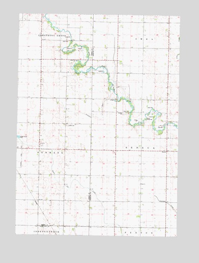
Seneca, IA USGS Topographic Map
Click on map above to begin viewing in our Map Viewer.

This topographic map contains these locations and features:
Feature Name Type Latitude Longitude GNIS ID View Map
Armstrong Grove Post Office (historical)Post OfficeN43.3647°W94.4694°466424View Map
Bacon Maker FarmLocaleN43.3692°W94.4695°2729866View Map
Blackjar Lutheran CemeteryCemeteryN43.2791°W94.4041°1925126View Map
Blackjer ChurchChurchN43.2786°W94.4041°1823044View Map
Crooked RunStreamN43.3333°W94.4286°1823040View Map
Des Moines River BridgeBridgeN43.3452°W94.4430°1925284View Map
East Des Moines Access Public Hunting AreaAreaN43.3597°W94.4603°464349View Map
ForsythPopulated PlaceN43.2555°W94.4730°464042View Map
Forsyth (historical)LocaleN43.2555°W94.4730°1907424View Map
Forsyth Post Office (historical)Post OfficeN43.2555°W94.4730°1907423View Map
Ringsted Memorial CemeteryCemeteryN43.3003°W94.4814°1907479View Map
Saint John ChurchChurchN43.3008°W94.4819°1823043View Map
Saint Johns Lutheran CemeteryCemeteryN43.3008°W94.4808°1907480View Map
Saint Pauls CemeteryCemeteryN43.3119°W94.4616°1823041View Map
SenecaPopulated PlaceN43.2991°W94.3841°461505View Map
Seneca AccessLocaleN43.3133°W94.4077°1925087View Map
Seneca Access Public Hunting AreaAreaN43.3141°W94.3980°464370View Map
Seneca Post Office (historical)Post OfficeN43.3319°W94.4336°466425View Map
Seneca Township CemeteryCemeteryN43.3197°W94.4186°1823042View Map
Township of SenecaCivilN43.2984°W94.3837°468679View Map

Note: Coordinates in the location and feature list above are referenced to NAD83 datum.


Copyright (C) 2008-2025 Ryan Niemi / Sunset Dynamics ... All Rights Reserved