TopoQuest Logo
Do you find TopoQuest useful?
Help keep TopoQuest running and adding new maps/features by donating!
Bitcoin:  19c7KJd3qBynnjoSw5npx9KScwjBe4ifkT
Litecoin:  LXs6TkuXGGXo1vDsWCkWVdjQX94eUKd6ui
Home View Maps Find Maps Find Places Resources & Links


Shawhan, Kentucky Topographic Map

USGS Map Title: Shawhan, KY
USGS Map MRC: 38084C3
DRG (GeoTIFF) Download: o38084c3.tif


Neighboring USGS Topographic Map Quads:


  Breckinridge, KY  
38084D4
 

  Cynthiana, KY  
38084D3
 

  Shady Nook, KY  
38084D2
 

  Leesburg, KY  
38084C4
 

  Shawhan, KY  
38084C3
 

  Millersburg, KY  
38084C2
 

  Centerville, KY  
38084B4
 

  Paris West, KY  
38084B3
 

  Paris East, KY  
38084B2


Map MRC Location:

N39°
W85°
N39°
W84°
H8 H7 H6 H5 H4 H3 H2 H1
G8 G7 G6 G5 G4 G3 G2 G1
F8 F7 F6 F5 F4 F3 F2 F1
E8 E7 E6 E5 E4 E3 E2 E1
D8 D7 D6 D5 D4 D3 D2 D1
C8 C7 C6 C5 C4 C3 C2 C1
B8 B7 B6 B5 B4 B3 B2 B1
A8 A7 A6 A5 A4 A3 A2 A1
N38°
W85°
N38°
W84°

Shawhan, KY USGS 1:24K Topographic Map Preview:
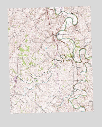
Shawhan, KY USGS Topographic Map
Click on map above to begin viewing in our Map Viewer.

This topographic map contains these locations and features:
Feature Name Type Latitude Longitude GNIS ID View Map
Acquia RunStreamN38.2562°W84.2699°494884View Map
BroadwellPopulated PlaceN38.3287°W84.3591°507589View Map
Broadwell Post Office (historical)Post OfficeN38.3287°W84.3591°2564165View Map
Broadwell School (historical)SchoolN38.3154°W84.3746°2564166View Map
Cedar BrookPopulated PlaceN38.3182°W84.3021°2742065View Map
Cooper RunStreamN38.2759°W84.2741°490062View Map
CurrentsvillePopulated PlaceN38.2609°W84.2510°490498View Map
Cynthiana Nursery (historical)LocaleN38.3476°W84.2709°2564179View Map
Cynthiana-Harrison County AirportAirportN38.3675°W84.2893°517360View Map
East Lair School (historical)SchoolN38.3486°W84.2744°2564181View Map
Edgewater BranchStreamN38.3415°W84.3022°491561View Map
Evergreen Valley Farm (historical)LocaleN38.3464°W84.2740°2564183View Map
Ewalt CrossroadsPopulated PlaceN38.2740°W84.2994°507964View Map
Flat RunStreamN38.2865°W84.2597°492217View Map
Huskens RunStreamN38.3131°W84.3066°494854View Map
JacksonvillePopulated PlaceN38.2729°W84.3658°495131View Map
KisertonPopulated PlaceN38.2770°W84.2760°508398View Map
LairPopulated PlaceN38.3420°W84.3077°495908View Map
Lair Post Office (historical)Post OfficeN38.3424°W84.3076°2564195View Map
Lairs Railroad Station (historical)LocaleN38.3423°W84.3024°2564196View Map
Mount Carmel Christian ChurchChurchN38.3062°W84.3038°498709View Map
Mount Pleasant ChurchChurchN38.3281°W84.3608°498850View Map
Mount Vernon School (historical)SchoolN38.3549°W84.3715°2564106View Map
Paddys RunStreamN38.3526°W84.2747°500105View Map
Pleasant Home Farm (historical)LocaleN38.3578°W84.3047°2564114View Map
Prospect Hill Farm (historical)LocaleN38.3513°W84.2761°2564119View Map
Ruddles Mill Shawhan Volunteer Fire DepartmentBuildingN38.3079°W84.2623°2637118View Map
Sellers RunStreamN38.3659°W84.2752°503160View Map
ShawhanPopulated PlaceN38.3017°W84.2724°503282View Map
Silas CreekStreamN38.2980°W84.3172°503493View Map
Smith CemeteryCemeteryN38.2706°W84.3522°503767View Map
Sunny Side Farm (historical)LocaleN38.3302°W84.3256°2564138View Map
Townsend CreekStreamN38.3150°W84.2792°505401View Map
Woodland Farm (historical)LocaleN38.3221°W84.2953°2564148View Map

Note: Coordinates in the location and feature list above are referenced to NAD83 datum.


Copyright (C) 2008-2025 Ryan Niemi / Sunset Dynamics ... All Rights Reserved