TopoQuest Logo
Do you find TopoQuest useful?
Help keep TopoQuest running and adding new maps/features by donating!
Bitcoin:  19c7KJd3qBynnjoSw5npx9KScwjBe4ifkT
Litecoin:  LXs6TkuXGGXo1vDsWCkWVdjQX94eUKd6ui
Home View Maps Find Maps Find Places Resources & Links


Shawnee Bend, Missouri Topographic Map

USGS Map Title: Shawnee Bend, MO
USGS Map MRC: 38093C4
DRG (GeoTIFF) Download: o38093c4.tif


Neighboring USGS Topographic Map Quads:


  Calhoun East, MO  
38093D5
 

  Lincoln NW, MO  
38093D4
 

  Lincoln, MO  
38093D3
 

  Leesville, MO  
38093C5
 

  Shawnee Bend, MO  
38093C4
 

  Lincoln SE, MO  
38093C3
 

  Ninnescah Park, MO  
38093B5
 

  Warsaw West, MO  
38093B4
 

  Warsaw East, MO  
38093B3


Map MRC Location:

N39°
W94°
N39°
W93°
H8 H7 H6 H5 H4 H3 H2 H1
G8 G7 G6 G5 G4 G3 G2 G1
F8 F7 F6 F5 F4 F3 F2 F1
E8 E7 E6 E5 E4 E3 E2 E1
D8 D7 D6 D5 D4 D3 D2 D1
C8 C7 C6 C5 C4 C3 C2 C1
B8 B7 B6 B5 B4 B3 B2 B1
A8 A7 A6 A5 A4 A3 A2 A1
N38°
W94°
N38°
W93°

Shawnee Bend, MO USGS 1:24K Topographic Map Preview:
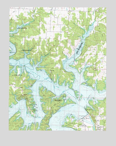
Shawnee Bend, MO USGS Topographic Map
Click on map above to begin viewing in our Map Viewer.

This topographic map contains these locations and features:
Feature Name Type Latitude Longitude GNIS ID View Map
Barber HollowValleyN38.3214°W93.4252°713636View Map
Baugh CemeteryCemeteryN38.3622°W93.4991°713744View Map
Baugh School (historical)SchoolN38.3611°W93.4910°713745View Map
Benson DamDamN38.3134°W93.4819°763063View Map
Benson LakeReservoirN38.3134°W93.4819°763064View Map
Bledsoe Ferry Public Use AreaParkN38.2620°W93.3980°743196View Map
Brush Creek State Wildlife Management AreaParkN38.3536°W93.4872°745548View Map
Cedar Hills Golf CourseLocaleN38.2597°W93.3852°743197View Map
Cherrydale School (historical)SchoolN38.3672°W93.4088°745373View Map
Cooper Cemetery (historical)CemeteryN38.2661°W93.4758°716276View Map
Cooper School (historical)SchoolN38.2686°W93.4766°745367View Map
Corn Hill School (historical)SchoolN38.2800°W93.4472°745366View Map
Crawfish HollowValleyN38.3045°W93.4074°716472View Map
Devils BackboneRidgeN38.2761°W93.4413°716857View Map
Dice CemeteryCemeteryN38.2659°W93.3830°743198View Map
Ditler CreekStreamN38.3684°W93.4688°716918View Map
Downing Cemetery (historical)CemeteryN38.2964°W93.4591°717033View Map
Flemming BranchStreamN38.3472°W93.4047°718015View Map
Gregory CemeteryCemeteryN38.3331°W93.4138°743202View Map
Harry S Truman DamDamN38.2631°W93.3880°729269View Map
Harry S Truman State ParkParkN38.2792°W93.4372°743204View Map
Hickory ChapelChurchN38.3592°W93.4933°719440View Map
Kaysinger BluffCliffN38.2700°W93.4002°720485View Map
Kaysinger Bluff Public Use AreaParkN38.2725°W93.3983°743199View Map
Kinkead CemeteryCemeteryN38.3123°W93.3892°720634View Map
Lane CemeteryCemeteryN38.3531°W93.3827°720796View Map
Limestone School (historical)SchoolN38.3059°W93.4222°745370View Map
Little Tebo CreekStreamN38.2842°W93.4033°721339View Map
Little Tebo Creek State Wildlife Management AreaParkN38.3309°W93.4058°743203View Map
Long Shoal BridgeBridgeN38.2561°W93.4752°755291View Map
Long Shoal Public Use AreaParkN38.2761°W93.4699°743205View Map
Macks CampPopulated PlaceN38.3100°W93.4463°738535View Map
Oak Grove School (historical)SchoolN38.3297°W93.4894°745364View Map
Orr School (historical)SchoolN38.3442°W93.3774°745371View Map
Osborn CemeteryCemeteryN38.3142°W93.4949°743206View Map
Passo (historical)LocaleN38.3389°W93.4230°744909View Map
Pleasant Grove School (historical)SchoolN38.3003°W93.3833°745369View Map
Poe CemeteryCemeteryN38.3117°W93.4080°743201View Map
RacketPopulated PlaceN38.2934°W93.4922°741184View Map
Racket School (historical)SchoolN38.3003°W93.4922°725049View Map
Riverside CemeteryCemeteryN38.2531°W93.3869°725348View Map
Shady Grove ChurchChurchN38.2961°W93.4963°726242View Map
Shawnee BendBendN38.2625°W93.4177°726291View Map
Shawnee Bend ChurchChurchN38.2550°W93.4083°726292View Map
Shawnee Bend Public Use AreaParkN38.2589°W93.4221°743195View Map
Shawnee Bend School (historical)SchoolN38.2534°W93.4108°745368View Map
Shawnee CemeteryCemeteryN38.2554°W93.4034°727095View Map
South Grand RiverStreamN38.2764°W93.4116°748543View Map
Spring Grove ChurchChurchN38.3195°W93.4180°726920View Map
Stevenson HollowValleyN38.3189°W93.4827°727089View Map
Sugarcamp HollowValleyN38.3134°W93.4677°729821View Map
Sunnyside CemeteryCemeteryN38.3713°W93.4242°2681317View Map
Sunnyside ChurchChurchN38.3714°W93.4252°729822View Map
Sunnyside School (historical)SchoolN38.3499°W93.4342°727311View Map
Sweatman HollowValleyN38.3600°W93.3855°727368View Map
Teal BendPopulated PlaceN38.2847°W93.4810°738536View Map
Tebo CreekStreamN38.3000°W93.4652°729826View Map
Thibaut Point Public Use AreaParkN38.2964°W93.3966°743200View Map
Tindle CemeteryCemeteryN38.3470°W93.4963°743209View Map
Township of Lindsey (historical)CivilN38.2725°W93.3794°766316View Map
Township of North LindseyCivilN38.3304°W93.3967°2045046View Map
Warsaw Fire and Rescue Station 6 RacketBuildingN38.2925°W93.4853°2621517View Map
Wilson HollowValleyN38.3528°W93.3933°728975View Map
Wrights IslandIslandN38.2736°W93.4272°729169View Map

Note: Coordinates in the location and feature list above are referenced to NAD83 datum.


Copyright (C) 2008-2025 Ryan Niemi / Sunset Dynamics ... All Rights Reserved