TopoQuest Logo
Do you find TopoQuest useful?
Help keep TopoQuest running and adding new maps/features by donating!
Bitcoin:  19c7KJd3qBynnjoSw5npx9KScwjBe4ifkT
Litecoin:  LXs6TkuXGGXo1vDsWCkWVdjQX94eUKd6ui
Home View Maps Find Maps Find Places Resources & Links


Warsaw West, Missouri Topographic Map

USGS Map Title: Warsaw West, MO
USGS Map MRC: 38093B4
DRG (GeoTIFF) Download: o38093b4.tif


Neighboring USGS Topographic Map Quads:


  Leesville, MO  
38093C5
 

  Shawnee Bend, MO  
38093C4
 

  Lincoln SE, MO  
38093C3
 

  Ninnescah Park, MO  
38093B5
 

  Warsaw West, MO  
38093B4
 

  Warsaw East, MO  
38093B3
 

  Iconium, MO  
38093A5
 

  Quincy, MO  
38093A4
 

  Fristoe, MO  
38093A3


Map MRC Location:

N39°
W94°
N39°
W93°
H8 H7 H6 H5 H4 H3 H2 H1
G8 G7 G6 G5 G4 G3 G2 G1
F8 F7 F6 F5 F4 F3 F2 F1
E8 E7 E6 E5 E4 E3 E2 E1
D8 D7 D6 D5 D4 D3 D2 D1
C8 C7 C6 C5 C4 C3 C2 C1
B8 B7 B6 B5 B4 B3 B2 B1
A8 A7 A6 A5 A4 A3 A2 A1
N38°
W94°
N38°
W93°

Warsaw West, MO USGS 1:24K Topographic Map Preview:
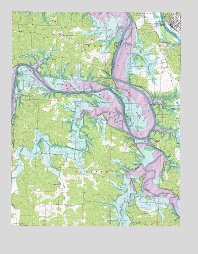
Warsaw West, MO USGS Topographic Map
Click on map above to begin viewing in our Map Viewer.

This topographic map contains these locations and features:
Feature Name Type Latitude Longitude GNIS ID View Map
Bailey Bridge (historical)BridgeN38.2011°W93.4233°741641View Map
Ballet Cemetery (historical)CemeteryN38.2328°W93.4077°713610View Map
Benton County Sheriff's OfficeBuildingN38.2422°W93.3805°2752418View Map
Campbell CemeteryCemeteryN38.1325°W93.3983°715301View Map
Cedar Grove ChurchChurchN38.2311°W93.4469°715596View Map
City Union Mission CampLocaleN38.2370°W93.4630°715857View Map
Cobb BluffCliffN38.2192°W93.4266°716049View Map
Cold SpringsPopulated PlaceN38.2314°W93.3833°716083View Map
Crabtree CemeteryCemeteryN38.1659°W93.3813°716447View Map
Fairfield (historical)Populated PlaceN38.1514°W93.3944°717733View Map
Fairfield ChurchChurchN38.1542°W93.3908°717734View Map
Fairfield Public Use AreaParkN38.1361°W93.4066°741945View Map
Freedom SchoolSchoolN38.1492°W93.4652°718201View Map
Goose Lake (historical)LakeN38.1909°W93.4213°718596View Map
Heath Bridge (historical)BridgeN38.2361°W93.4149°741639View Map
Hogles CreekStreamN38.1789°W93.4127°756187View Map
Hogles Creek Church (historical)ChurchN38.1814°W93.4571°719692View Map
Hogles Creek School (historical)SchoolN38.1959°W93.4524°719693View Map
Indian HillSummitN38.1472°W93.4066°720135View Map
Laird BluffCliffN38.2070°W93.4063°720740View Map
Little Hogles CreekStreamN38.1714°W93.4713°721249View Map
Little Pomme de Terre RiverStreamN38.1578°W93.4013°721300View Map
Mockingbird HillSummitN38.1578°W93.3871°722507View Map
Mount Hope School (historical)SchoolN38.1697°W93.4274°741644View Map
Mount Olive Church (historical)ChurchN38.1631°W93.4966°741645View Map
National SchoolSchoolN38.2281°W93.4458°741638View Map
Negro Springs Camp (historical)LocaleN38.1328°W93.3788°723158View Map
Opportunity FarmsPopulated PlaceN38.2342°W93.4580°738037View Map
Osage Bluff Public Use AreaParkN38.1906°W93.3935°741944View Map
Peal Bend (historical)BendN38.1953°W93.4102°724148View Map
Peal Bend Bridge (historical)BridgeN38.1956°W93.3974°741643View Map
Peal Bend School (historical)SchoolN38.1964°W93.4119°741642View Map
Peal Cemetery (historical)CemeteryN38.1836°W93.4127°724149View Map
Pom-o-sa HeightsPopulated PlaceN38.1745°W93.3960°724723View Map
Pomme de Terre HallLocaleN38.1375°W93.4119°724725View Map
R 10 SchoolSchoolN38.2372°W93.4685°725029View Map
Sugarcamp HollowValleyN38.2125°W93.4269°727261View Map
TacknerPopulated PlaceN38.2359°W93.4299°741310View Map
Tatge Lake Section 29 DamDamN38.2234°W93.3935°763803View Map
Township of AlexanderCivilN38.1352°W93.4291°766313View Map
Township of TomCivilN38.2479°W93.4517°766317View Map
Turpin BranchStreamN38.1975°W93.3969°727913View Map
Valley ViewPopulated PlaceN38.2061°W93.4283°728105View Map
Vance BranchStreamN38.1820°W93.3944°728128View Map
Walnut Grove SchoolSchoolN38.2172°W93.3902°741640View Map
WarsawPopulated PlaceN38.2431°W93.3819°728365View Map
Warsaw Fire and Rescue Station 1BuildingN38.2406°W93.3795°2620984View Map
Warsaw Fire and Rescue Station 5 Bent TreeBuildingN38.2398°W93.4956°2621518View Map
Warsaw Police DepartmentBuildingN38.2411°W93.3820°2752508View Map
Warsaw Post OfficePost OfficeN38.2429°W93.3821°2779464View Map
WisdomPopulated PlaceN38.1670°W93.4769°741369View Map
Wisdom CemeteryCemeteryN38.1775°W93.4799°729016View Map

Note: Coordinates in the location and feature list above are referenced to NAD83 datum.


Copyright (C) 2008-2024 Ryan Niemi / Sunset Dynamics ... All Rights Reserved