TopoQuest Logo
Do you find TopoQuest useful?
Help keep TopoQuest running and adding new maps/features by donating!
Bitcoin:  19c7KJd3qBynnjoSw5npx9KScwjBe4ifkT
Litecoin:  LXs6TkuXGGXo1vDsWCkWVdjQX94eUKd6ui
Home View Maps Find Maps Find Places Resources & Links


Shay Mountain, Utah Topographic Map

USGS Map Title: Shay Mountain, UT
USGS Map MRC: 37109H5
DRG (GeoTIFF) Download: o37109h5.tif


Neighboring USGS Topographic Map Quads:


  South Six-shooter Peak, UT  
38109A6
 

  Harts Point South, UT  
38109A5
 

  Photograph Gap, UT  
38109A4
 

  Cathedral Butte, UT  
37109H6
 

  Shay Mountain, UT  
37109H5
 

  Monticello Lake, UT  
37109H4
 

  Chippean Rocks, UT  
37109G6
 

  Mount Linnaeus, UT  
37109G5
 

  Abajo Peak, UT  
37109G4


Map MRC Location:

N38°
W110°
N38°
W109°
H8 H7 H6 H5 H4 H3 H2 H1
G8 G7 G6 G5 G4 G3 G2 G1
F8 F7 F6 F5 F4 F3 F2 F1
E8 E7 E6 E5 E4 E3 E2 E1
D8 D7 D6 D5 D4 D3 D2 D1
C8 C7 C6 C5 C4 C3 C2 C1
B8 B7 B6 B5 B4 B3 B2 B1
A8 A7 A6 A5 A4 A3 A2 A1
N37°
W110°
N37°
W109°

Shay Mountain, UT USGS 1:24K Topographic Map Preview:
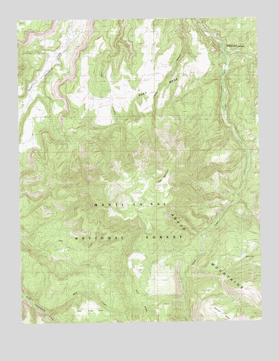
Shay Mountain, UT USGS Topographic Map
Click on map above to begin viewing in our Map Viewer.

This topographic map contains these locations and features:
Feature Name Type Latitude Longitude GNIS ID View Map
Blue CreekStreamN37.8789°W109.6115°1438928View Map
Blue Creek PointSummitN37.8783°W109.5985°1448153View Map
Kelly RanchLocaleN37.9830°W109.5157°1442296View Map
Manti-La Sal National Forest - La Sal DivisionForestN37.8753°W109.5004°1451292View Map
Newspaper Rock CampgroundLocaleN37.9880°W109.5190°1448739View Map
Newspaper Rock State Historical MonumentParkN37.9880°W109.5185°1450446View Map
Newspaper Rock TowerTowerN37.9880°W109.5185°1450031View Map
Robertson PastureFlatN37.8778°W109.5176°1445021View Map
Shay MesaSummitN37.9744°W109.5701°1445475View Map
Shay MountainSummitN37.9358°W109.5490°1445476View Map
Spring LakeReservoirN37.9000°W109.5090°1447661View Map
Spring Lake DamDamN37.9000°W109.5090°1447662View Map
Wilson RanchLocaleN37.9769°W109.6135°1447459View Map

Note: Coordinates in the location and feature list above are referenced to NAD83 datum.


Copyright (C) 2008-2025 Ryan Niemi / Sunset Dynamics ... All Rights Reserved