TopoQuest Logo
Do you find TopoQuest useful?
Help keep TopoQuest running and adding new maps/features by donating!
Bitcoin:  19c7KJd3qBynnjoSw5npx9KScwjBe4ifkT
Litecoin:  LXs6TkuXGGXo1vDsWCkWVdjQX94eUKd6ui
Home View Maps Find Maps Find Places Resources & Links


Chippean Rocks, Utah Topographic Map

USGS Map Title: Chippean Rocks, UT
USGS Map MRC: 37109G6
DRG (GeoTIFF) Download: o37109g6.tif


Neighboring USGS Topographic Map Quads:


  House Park Butte, UT  
37109H7
 

  Cathedral Butte, UT  
37109H6
 

  Shay Mountain, UT  
37109H5
 

  Poison Canyon, UT  
37109G7
 

  Chippean Rocks, UT  
37109G6
 

  Mount Linnaeus, UT  
37109G5
 

  Kigalia Point, UT  
37109F7
 

  Cream Pots, UT  
37109F6
 

  Mancos Jim Butte, UT  
37109F5


Map MRC Location:

N38°
W110°
N38°
W109°
H8 H7 H6 H5 H4 H3 H2 H1
G8 G7 G6 G5 G4 G3 G2 G1
F8 F7 F6 F5 F4 F3 F2 F1
E8 E7 E6 E5 E4 E3 E2 E1
D8 D7 D6 D5 D4 D3 D2 D1
C8 C7 C6 C5 C4 C3 C2 C1
B8 B7 B6 B5 B4 B3 B2 B1
A8 A7 A6 A5 A4 A3 A2 A1
N37°
W110°
N37°
W109°

Chippean Rocks, UT USGS 1:24K Topographic Map Preview:
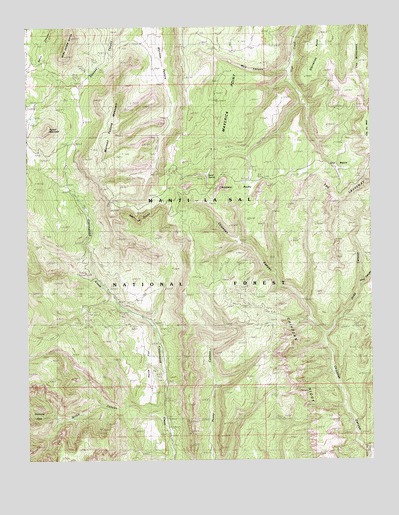
Chippean Rocks, UT USGS Topographic Map
Click on map above to begin viewing in our Map Viewer.

This topographic map contains these locations and features:
Feature Name Type Latitude Longitude GNIS ID View Map
Avalanche MineMineN37.7919°W109.7143°1450020View Map
Black Bean MineMineN37.7936°W109.7179°1450019View Map
Chippean CanyonValleyN37.7525°W109.6282°1439698View Map
Chippean RidgeRidgeN37.7814°W109.6596°1439699View Map
Chippean RocksSummitN37.8269°W109.6715°1439700View Map
Deep CanyonValleyN37.7861°W109.6421°1440340View Map
Dry BasinBasinN37.8350°W109.6373°1448352View Map
Horse FlatFlatN37.7814°W109.7190°1441871View Map
Maverick PointCapeN37.8733°W109.6901°1443232View Map
Maverick Point OverlookLocaleN37.8344°W109.6271°1453031View Map
Maverick Visitor Information SiteLocaleN37.8344°W109.6987°1450018View Map
Mormon PastureFlatN37.8603°W109.7004°1443591View Map
Mormon Pasture MountainSummitN37.8542°W109.7229°1448690View Map
Mud CanyonValleyN37.8619°W109.6548°1448707View Map
Mule CanyonValleyN37.8008°W109.6290°1443726View Map
Notch CanyonValleyN37.7625°W109.7026°1444001View Map
Reef of RocksRidgeN37.8208°W109.7099°1450478View Map
Round MountainSummitN37.8453°W109.7424°1445170View Map
Sand SpringSpringN37.8317°W109.6850°1448970View Map
Seven Sisters ButtesSummitN37.8666°W109.7363°1445439View Map
Starvation PointCapeN37.8728°W109.6435°1446102View Map
The WildernessAreaN37.8575°W109.6340°1446518View Map

Note: Coordinates in the location and feature list above are referenced to NAD83 datum.


Copyright (C) 2008-2024 Ryan Niemi / Sunset Dynamics ... All Rights Reserved