TopoQuest Logo
Do you find TopoQuest useful?
Help keep TopoQuest running and adding new maps/features by donating!
Bitcoin:  19c7KJd3qBynnjoSw5npx9KScwjBe4ifkT
Litecoin:  LXs6TkuXGGXo1vDsWCkWVdjQX94eUKd6ui
Home View Maps Find Maps Find Places Resources & Links


Cathedral Butte, Utah Topographic Map

USGS Map Title: Cathedral Butte, UT
USGS Map MRC: 37109H6
DRG (GeoTIFF) Download: o37109h6.tif


Neighboring USGS Topographic Map Quads:


  Druid Arch, UT  
38109A7
 

  South Six-shooter Peak, UT  
38109A6
 

  Harts Point South, UT  
38109A5
 

  House Park Butte, UT  
37109H7
 

  Cathedral Butte, UT  
37109H6
 

  Shay Mountain, UT  
37109H5
 

  Poison Canyon, UT  
37109G7
 

  Chippean Rocks, UT  
37109G6
 

  Mount Linnaeus, UT  
37109G5


Map MRC Location:

N38°
W110°
N38°
W109°
H8 H7 H6 H5 H4 H3 H2 H1
G8 G7 G6 G5 G4 G3 G2 G1
F8 F7 F6 F5 F4 F3 F2 F1
E8 E7 E6 E5 E4 E3 E2 E1
D8 D7 D6 D5 D4 D3 D2 D1
C8 C7 C6 C5 C4 C3 C2 C1
B8 B7 B6 B5 B4 B3 B2 B1
A8 A7 A6 A5 A4 A3 A2 A1
N37°
W110°
N37°
W109°

Cathedral Butte, UT USGS 1:24K Topographic Map Preview:
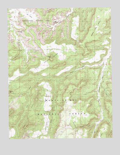
Cathedral Butte, UT USGS Topographic Map
Click on map above to begin viewing in our Map Viewer.

This topographic map contains these locations and features:
Feature Name Type Latitude Longitude GNIS ID View Map
Betty MineMineN37.8767°W109.7254°1450027View Map
Big PocketBasinN37.9939°W109.7221°1438716View Map
Boundary ButteSummitN37.9202°W109.7496°1439035View Map
Bridger JackLocaleN37.9644°W109.6651°1439100View Map
Bridger Jack MesaSummitN37.9644°W109.6650°1439101View Map
Cathedral ButteSummitN37.9529°W109.6986°1439538View Map
Cathedral PointCapeN37.9805°W109.7235°1448235View Map
Cleft ArchArchN37.9861°W109.6917°1450301View Map
Davis CanyonValleyN37.9294°W109.6898°1440281View Map
East Fork Salt CreekStreamN37.9800°W109.7451°1440819View Map
Hop CreekStreamN37.9264°W109.6401°1441842View Map
Kirk CabinLocaleN37.9842°W109.7451°1448550View Map
Lavender PointCliffN37.9897°W109.6810°1448581View Map
Mormon Pasture PointCapeN37.9025°W109.7112°1443592View Map
Natural BridgeArchN37.9833°W109.7285°1448725View Map
North Cottonwood Guard StationLocaleN37.9244°W109.6426°1453032View Map
Reservoir CanyonValleyN37.8913°W109.6406°1444869View Map
Salt Creek MesaSummitN37.9202°W109.7496°1445281View Map
Stevens CanyonValleyN37.9509°W109.6319°1446138View Map
Vega CreekStreamN37.8939°W109.6365°1446918View Map
Wedding Ring ArchArchN37.9778°W109.7329°1450545View Map

Note: Coordinates in the location and feature list above are referenced to NAD83 datum.


Copyright (C) 2008-2024 Ryan Niemi / Sunset Dynamics ... All Rights Reserved