TopoQuest Logo
Do you find TopoQuest useful?
Help keep TopoQuest running and adding new maps/features by donating!
Bitcoin:  19c7KJd3qBynnjoSw5npx9KScwjBe4ifkT
Litecoin:  LXs6TkuXGGXo1vDsWCkWVdjQX94eUKd6ui
Home View Maps Find Maps Find Places Resources & Links


Shenandoah West, Iowa Topographic Map

USGS Map Title: Shenandoah West, IA
USGS Map MRC: 40095G4
DRG (GeoTIFF) Download: o40095g4.tif


Neighboring USGS Topographic Map Quads:


  Tabor NE, IA  
40095H5
 

  Imogene, IA  
40095H4
 

  Coburg, IA  
40095H3
 

  Randolph, IA  
40095G5
 

  Shenandoah West, IA  
40095G4
 

  Shenandoah East, IA  
40095G3
 

  Riverton, IA  
40095F5
 

  Farragut, IA  
40095F4
 

  Bingham, IA  
40095F3


Map MRC Location:

N41°
W96°
N41°
W95°
H8 H7 H6 H5 H4 H3 H2 H1
G8 G7 G6 G5 G4 G3 G2 G1
F8 F7 F6 F5 F4 F3 F2 F1
E8 E7 E6 E5 E4 E3 E2 E1
D8 D7 D6 D5 D4 D3 D2 D1
C8 C7 C6 C5 C4 C3 C2 C1
B8 B7 B6 B5 B4 B3 B2 B1
A8 A7 A6 A5 A4 A3 A2 A1
N40°
W96°
N40°
W95°

Shenandoah West, IA USGS 1:24K Topographic Map Preview:
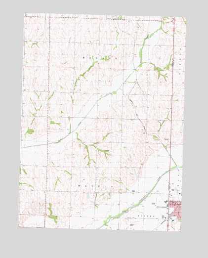
Shenandoah West, IA USGS Topographic Map
Click on map above to begin viewing in our Map Viewer.

This topographic map contains these locations and features:
Feature Name Type Latitude Longitude GNIS ID View Map
CoreyLocaleN40.8000°W95.4414°466334View Map
Cory Post Office (historical)Post OfficeN40.7778°W95.4414°1949841View Map
Fair Oaks Care CenterHospitalN40.7567°W95.3767°1968517View Map
Faith Christian FellowshipChurchN40.7739°W95.3786°1968502View Map
Farmer CityLocaleN40.8292°W95.4797°466332View Map
Farmer City Post Office (historical)Post OfficeN40.8292°W95.4797°1949840View Map
Fiftyniner Motel and CampgroundsLocaleN40.7550°W95.3864°1949815View Map
Fisher CreekStreamN40.7525°W95.4336°456618View Map
Garden View Care CenterHospitalN40.7564°W95.3808°1968516View Map
Grace Community FellowshipChurchN40.7661°W95.3808°1968531View Map
Hunter BranchStreamN40.8050°W95.4630°457727View Map
Living Word AcademySchoolN40.7564°W95.3814°1968535View Map
Lowell Avenue Elementary SchoolSchoolN40.7669°W95.3808°1968536View Map
Memorial Baptist ChurchChurchN40.7611°W95.3755°1968529View Map
Mercy Center of ShenandoahHospitalN40.7714°W95.3855°1968498View Map
Mount Calvary CemeteryCemeteryN40.8722°W95.4211°1949951View Map
New Testament Church of ChristChurchN40.7697°W95.3847°1968501View Map
Nunda (historical)LocaleN40.8289°W95.4183°1949831View Map
Nunda Post Office (historical)Post OfficeN40.8289°W95.4183°1949830View Map
ShenandoahLocaleN40.7661°W95.3758°1968514View Map
Shenandoah Municipal AirportAirportN40.7517°W95.4067°466934View Map
SummitPopulated PlaceN40.8292°W95.4180°464312View Map
Towell Avenue SchoolSchoolN40.7672°W95.3803°462282View Map
Township of MonroeCivilN40.8582°W95.4420°468393View Map
Township of WalnutCivilN40.7830°W95.4488°468884View Map
Vaughn Post Office (historical)Post OfficeN40.7994°W95.4847°466504View Map
Walnut Creek Post Office (historical)Post OfficeN40.7783°W95.4411°1949842View Map

Note: Coordinates in the location and feature list above are referenced to NAD83 datum.


Copyright (C) 2008-2025 Ryan Niemi / Sunset Dynamics ... All Rights Reserved