TopoQuest Logo
Do you find TopoQuest useful?
Help keep TopoQuest running and adding new maps/features by donating!
Bitcoin:  19c7KJd3qBynnjoSw5npx9KScwjBe4ifkT
Litecoin:  LXs6TkuXGGXo1vDsWCkWVdjQX94eUKd6ui
Home View Maps Find Maps Find Places Resources & Links


England, Arkansas Topographic Map

USGS Map Title: England, AR
USGS Map MRC: 34091E8
DRG (GeoTIFF) Download: o34091e8.tif


Neighboring USGS Topographic Map Quads:


  Scott, AR  
34092F1
 

  Pettus, AR  
34091F8
 

  Culler, AR  
34091F7
 

  Keo, AR  
34092E1
 

  England, AR  
34091E8
 

  Humnoke, AR  
34091E7
 

  Wright, AR  
34092D1
 

  Sherrill, AR  
34091D8
 

  Gethsemane, AR  
34091D7


Map MRC Location:

N35°
W92°
N35°
W91°
H8 H7 H6 H5 H4 H3 H2 H1
G8 G7 G6 G5 G4 G3 G2 G1
F8 F7 F6 F5 F4 F3 F2 F1
E8 E7 E6 E5 E4 E3 E2 E1
D8 D7 D6 D5 D4 D3 D2 D1
C8 C7 C6 C5 C4 C3 C2 C1
B8 B7 B6 B5 B4 B3 B2 B1
A8 A7 A6 A5 A4 A3 A2 A1
N34°
W92°
N34°
W91°

England, AR USGS 1:24K Topographic Map Preview:
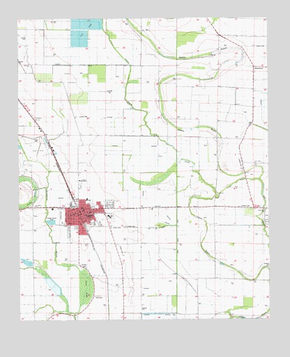
England, AR USGS Topographic Map
Click on map above to begin viewing in our Map Viewer.

This topographic map contains these locations and features:
Feature Name Type Latitude Longitude GNIS ID View Map
BlakemorePopulated PlaceN34.6048°W91.8821°61178View Map
Boyd (historical)Populated PlaceN34.5390°W91.9257°61401View Map
Capps Airport (historical)AirportN34.5806°W91.9682°83691View Map
Central SchoolSchoolN34.5756°W91.8957°47664View Map
Chapel Hill ChurchChurchN34.5445°W91.8771°61183View Map
Church of ChristChurchN34.5468°W91.9685°61397View Map
City of EnglandCivilN34.5461°W91.9690°2403566View Map
Coy Fire DepartmentBuildingN34.5411°W91.8760°2116323View Map
Cross BayouGutN34.5576°W91.8896°48188View Map
Dodson School (historical)SchoolN34.5834°W91.9274°61403View Map
Emergency Ambulance Service EnglandBuildingN34.5463°W91.9694°2119091View Map
EnglandPopulated PlaceN34.5443°W91.9690°76878View Map
England AcademySchoolN34.5579°W91.9696°61187View Map
England Elementary SchoolSchoolN34.5400°W91.9627°61394View Map
England Flying Service Airport (historical)AirportN34.5418°W91.9835°83690View Map
England High SchoolSchoolN34.5433°W91.9554°61396View Map
England HospitalHospitalN34.5501°W91.9660°61400View Map
England Middle SchoolSchoolN34.5451°W91.9562°2039193View Map
England Police DepartmentBuildingN34.5448°W91.9714°2118682View Map
England Post OfficePost OfficeN34.5451°W91.9682°84027View Map
England Volunteer Fire DepartmentBuildingN34.5450°W91.9711°2116405View Map
First Assembly of God ChurchChurchN34.5459°W91.9626°61395View Map
First Baptist ChurchChurchN34.5459°W91.9679°61399View Map
First United Methodist ChurchChurchN34.5468°W91.9688°61398View Map
Gumwood ChurchChurchN34.6065°W91.9949°49737View Map
Holy Trinity ChurchChurchN34.5476°W91.9924°61191View Map
Hunley Chapel (historical)ChurchN34.5756°W91.9251°61402View Map
Indian Bayou DitchCanalN34.6065°W91.9449°77269View Map
Jebbs School (historical)SchoolN34.5587°W91.8829°61405View Map
KLRA-AM (England)TowerN34.5459°W91.9846°85076View Map
KLRA-FM (England)TowerN34.5459°W91.9846°85176View Map
Landmark Baptist ChurchChurchN34.5437°W91.9743°61393View Map
Macedonia SchoolSchoolN34.5132°W91.9129°51585View Map
Miller School (historical)SchoolN34.6109°W91.9032°61407View Map
Mount Zion ChurchChurchN34.6095°W91.9035°52469View Map
Mulberry CemeteryCemeteryN34.5220°W91.9671°52533View Map
Nelon BrakeSwampN34.5134°W91.9673°61195View Map
Nelon CemeteryCemeteryN34.5095°W91.9629°61196View Map
Pentecostal Church of GodChurchN34.5437°W91.9757°61392View Map
Perry School (historical)SchoolN34.5956°W91.8915°61406View Map
Salt LakeLakeN34.5533°W91.8781°61404View Map
Southside Baptist ChurchChurchN34.5359°W91.9701°61391View Map
Tomberlin CemeteryCemeteryN34.5218°W91.8754°61205View Map
Tomberlin SchoolSchoolN34.5023°W91.8976°55601View Map
Township of Gum WoodsCivilN34.5328°W91.9756°68821View Map
Township of LafayetteCivilN34.6100°W91.9928°68825View Map
Township of PettusCivilN34.6145°W91.8954°68829View Map
Union Valley ChurchChurchN34.5640°W91.8815°61207View Map

Note: Coordinates in the location and feature list above are referenced to NAD83 datum.


Copyright (C) 2008-2024 Ryan Niemi / Sunset Dynamics ... All Rights Reserved