TopoQuest Logo
Do you find TopoQuest useful?
Help keep TopoQuest running and adding new maps/features by donating!
Bitcoin:  19c7KJd3qBynnjoSw5npx9KScwjBe4ifkT
Litecoin:  LXs6TkuXGGXo1vDsWCkWVdjQX94eUKd6ui
Home View Maps Find Maps Find Places Resources & Links


Shieldsville, Minnesota Topographic Map

USGS Map Title: Shieldsville, MN
USGS Map MRC: 44093C4
DRG (GeoTIFF) Download: o44093c4.tif


Neighboring USGS Topographic Map Quads:


  Montgomery, MN  
44093D5
 

  Lonsdale, MN  
44093D4
 

  Little Chicago, MN  
44093D3
 

  Kilkenny, MN  
44093C5
 

  Shieldsville, MN  
44093C4
 

  Faribault, MN  
44093C3
 

  Waterville, MN  
44093B5
 

  Morristown, MN  
44093B4
 

  Medford West, MN  
44093B3


Map MRC Location:

N45°
W94°
N45°
W93°
H8 H7 H6 H5 H4 H3 H2 H1
G8 G7 G6 G5 G4 G3 G2 G1
F8 F7 F6 F5 F4 F3 F2 F1
E8 E7 E6 E5 E4 E3 E2 E1
D8 D7 D6 D5 D4 D3 D2 D1
C8 C7 C6 C5 C4 C3 C2 C1
B8 B7 B6 B5 B4 B3 B2 B1
A8 A7 A6 A5 A4 A3 A2 A1
N44°
W94°
N44°
W93°

Shieldsville, MN USGS 1:24K Topographic Map Preview:
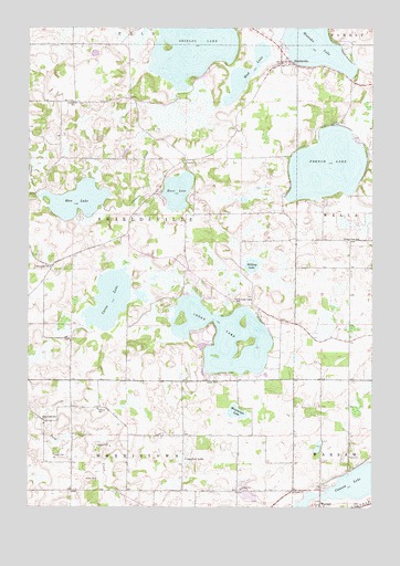
Shieldsville, MN USGS Topographic Map
Click on map above to begin viewing in our Map Viewer.

This topographic map contains these locations and features:
Feature Name Type Latitude Longitude GNIS ID View Map
Apple Creek OrchardLocaleN44.3178°W93.3764°2651170View Map
Caron LakeLakeN44.3047°W93.4698°640923View Map
Cedar LakeLakeN44.2945°W93.4287°641007View Map
Crawford LakeSwampN44.2622°W93.4447°642434View Map
Fox Hill FarmLocaleN44.3389°W93.4556°2651175View Map
French LakeLakeN44.3391°W93.3919°643936View Map
Hunt LakeLakeN44.3324°W93.4461°645292View Map
Kennyville SchoolSchoolN44.2727°W93.4944°646105View Map
Lake View SchoolSchoolN44.3200°W93.3855°646401View Map
Mazaska LakeLakeN44.3727°W93.3962°647647View Map
Mud LakeLakeN44.3629°W93.4217°648216View Map
North Cedar Lake SchoolSchoolN44.3033°W93.4247°648625View Map
Rice LakeLakeN44.3298°W93.4821°649978View Map
Rice LakeReservoirN44.3316°W93.4969°1776478View Map
Rice Lake DamDamN44.3316°W93.4969°1776477View Map
School Number 1797SchoolN44.3125°W93.4922°651422View Map
Shields LakeLakeN44.3700°W93.4414°651980View Map
ShieldsvillePopulated PlaceN44.3661°W93.4088°651981View Map
Township of ShieldsvilleCivilN44.3267°W93.4640°665600View Map
Trebon SchoolSchoolN44.3552°W93.4836°653271View Map
Trinity Lutheran SchoolSchoolN44.2757°W93.4748°2433307View Map
Trinity SchoolSchoolN44.2758°W93.4747°653322View Map
Warsaw Census Designated PlaceCensusN44.2576°W93.3771°2628696View Map
Weinberger LakeLakeN44.2748°W93.4249°653895View Map
Willing LakeLakeN44.3130°W93.4191°654175View Map

Note: Coordinates in the location and feature list above are referenced to NAD83 datum.


Copyright (C) 2008-2024 Ryan Niemi / Sunset Dynamics ... All Rights Reserved