TopoQuest Logo
Do you find TopoQuest useful?
Help keep TopoQuest running and adding new maps/features by donating!
Bitcoin:  19c7KJd3qBynnjoSw5npx9KScwjBe4ifkT
Litecoin:  LXs6TkuXGGXo1vDsWCkWVdjQX94eUKd6ui
Home View Maps Find Maps Find Places Resources & Links


Kilkenny, Minnesota Topographic Map

USGS Map Title: Kilkenny, MN
USGS Map MRC: 44093C5
DRG (GeoTIFF) Download: o44093c5.tif


Neighboring USGS Topographic Map Quads:


  Le Center, MN  
44093D6
 

  Montgomery, MN  
44093D5
 

  Lonsdale, MN  
44093D4
 

  Cordova, MN  
44093C6
 

  Kilkenny, MN  
44093C5
 

  Shieldsville, MN  
44093C4
 

  Elysian, MN  
44093B6
 

  Waterville, MN  
44093B5
 

  Morristown, MN  
44093B4


Map MRC Location:

N45°
W94°
N45°
W93°
H8 H7 H6 H5 H4 H3 H2 H1
G8 G7 G6 G5 G4 G3 G2 G1
F8 F7 F6 F5 F4 F3 F2 F1
E8 E7 E6 E5 E4 E3 E2 E1
D8 D7 D6 D5 D4 D3 D2 D1
C8 C7 C6 C5 C4 C3 C2 C1
B8 B7 B6 B5 B4 B3 B2 B1
A8 A7 A6 A5 A4 A3 A2 A1
N44°
W94°
N44°
W93°

Kilkenny, MN USGS 1:24K Topographic Map Preview:
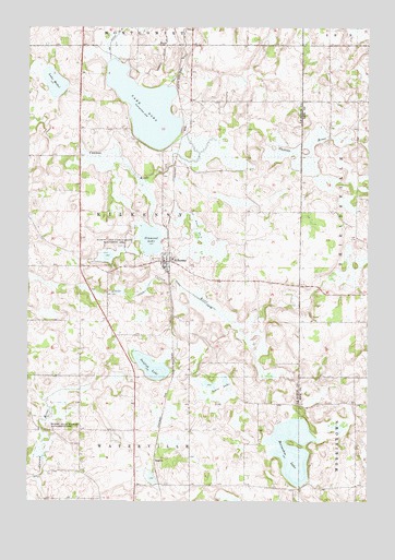
Kilkenny, MN USGS Topographic Map
Click on map above to begin viewing in our Map Viewer.

This topographic map contains these locations and features:
Feature Name Type Latitude Longitude GNIS ID View Map
Calvary CemeteryCemeteryN44.3125°W93.5917°2063558View Map
Church of Saint CaniceChurchN44.3133°W93.5739°2063551View Map
City of KilkennyCivilN44.3151°W93.5743°2395528View Map
Cordova Family CemeteryCemeteryN44.3125°W93.5914°2063557View Map
County Ditch Number FifteenCanalN44.3216°W93.5633°641693View Map
County Ditch Number FiftysevenCanalN44.3664°W93.5761°642196View Map
County Ditch Number FortyCanalN44.3747°W93.5908°642067View Map
County Ditch Number SixtysixCanalN44.3064°W93.5686°642260View Map
Diamond LakeLakeN44.3190°W93.5800°642798View Map
Diamond Lake State Wildlife Management ArParkN44.3164°W93.5888°642807View Map
DoylePopulated PlaceN44.3702°W93.5750°654677View Map
Doyle Post Office (historical)Post OfficeN44.3703°W93.5747°2063541View Map
Gish CemeteryCemeteryN44.2529°W93.5826°2611491View Map
Gishville (historical)Populated PlaceN44.2610°W93.5861°2611495View Map
Gishville School (historical)SchoolN44.2611°W93.5861°2611497View Map
Goose LakeLakeN44.2805°W93.5563°644239View Map
Gregor Farm CemeteryCemeteryN44.2811°W93.5667°2063577View Map
Horseshoe LakeLakeN44.2638°W93.5275°645205View Map
Horseshoe Lake CemeteryCemeteryN44.2542°W93.5286°2063576View Map
KilkennyPopulated PlaceN44.3133°W93.5741°646140View Map
Kilkenny (historical)LocaleN44.3144°W93.5736°2063559View Map
Kilkenny Fire DepartmentBuildingN44.3132°W93.5757°2666276View Map
Kilkenny Post OfficePost OfficeN44.3132°W93.5755°2063549View Map
Kilkenny Public LibraryBuildingN44.3133°W93.5739°2063550View Map
Lake DoraLakeN44.3540°W93.5820°642889View Map
Lake MabelLakeN44.3603°W93.6155°647348View Map
Lesueur County Waterfowl Production AreaParkN44.3666°W93.5805°2765371View Map
Madden's OrchardLocaleN44.2736°W93.5208°2651201View Map
Murphy State Wildlife Management AreaParkN44.2694°W93.6199°648394View Map
RogersPopulated PlaceN44.2605°W93.5786°654910View Map
Sunfish LakeLakeN44.2855°W93.5796°652813View Map
Township of KilkennyCivilN44.3266°W93.5856°664630View Map
United Brethren Church (historical)ChurchN44.2611°W93.5861°2611496View Map

Note: Coordinates in the location and feature list above are referenced to NAD83 datum.


Copyright (C) 2008-2025 Ryan Niemi / Sunset Dynamics ... All Rights Reserved