TopoQuest Logo
Do you find TopoQuest useful?
Help keep TopoQuest running and adding new maps/features by donating!
Bitcoin:  19c7KJd3qBynnjoSw5npx9KScwjBe4ifkT
Litecoin:  LXs6TkuXGGXo1vDsWCkWVdjQX94eUKd6ui
Home View Maps Find Maps Find Places Resources & Links


Shiloh, New Jersey Topographic Map

USGS Map Title: Shiloh, NJ
USGS Map MRC: 39075D3
DRG (GeoTIFF) Download: o39075d3.tif


Neighboring USGS Topographic Map Quads:


  Salem, NJ  
39075E4
 

  Alloway, NJ  
39075E3
 

  Elmer, NJ  
39075E2
 

  Canton, NJ  
39075D4
 

  Shiloh, NJ  
39075D3
 

  Bridgeton, NJ  
39075D2
 

  Bombay Hook Island, DE  
39075C4
 

  Ben Davis Point, NJ  
39075C3
 

  Cedarville, NJ  
39075C2


Map MRC Location:

N40°
W76°
N40°
W75°
H8 H7 H6 H5 H4 H3 H2 H1
G8 G7 G6 G5 G4 G3 G2 G1
F8 F7 F6 F5 F4 F3 F2 F1
E8 E7 E6 E5 E4 E3 E2 E1
D8 D7 D6 D5 D4 D3 D2 D1
C8 C7 C6 C5 C4 C3 C2 C1
B8 B7 B6 B5 B4 B3 B2 B1
A8 A7 A6 A5 A4 A3 A2 A1
N39°
W76°
N39°
W75°

Shiloh, NJ USGS 1:24K Topographic Map Preview:
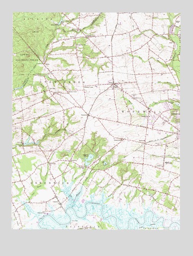
Shiloh, NJ USGS Topographic Map
Click on map above to begin viewing in our Map Viewer.

This topographic map contains these locations and features:
Feature Name Type Latitude Longitude GNIS ID View Map
B J Farms AirportAirportN39.4576°W75.2730°884929View Map
Barrett RunStreamN39.4482°W75.2541°874516View Map
Beebe RunStreamN39.4707°W75.2559°874633View Map
Bishop RunStreamN39.4599°W75.3653°874774View Map
Borough of ShilohCivilN39.4595°W75.2970°885393View Map
BowentownPopulated PlaceN39.4246°W75.2763°874868View Map
Browns RunStreamN39.3901°W75.3078°874984View Map
Campbells CornerPopulated PlaceN39.4859°W75.3188°875168View Map
Cedar Hill CemeteryCemeteryN39.4246°W75.2644°875290View Map
Chestnut RunStreamN39.4258°W75.3547°875411View Map
Coffin HillSummitN39.4898°W75.3582°875533View Map
Cumberland County Juvenile Detention CenterBuildingN39.4130°W75.2604°2733244View Map
Davis MillPopulated PlaceN39.4248°W75.3666°875812View Map
Davis MillpondReservoirN39.4243°W75.3624°883107View Map
Davis Millpond DamDamN39.4237°W75.3663°884285View Map
Devereux New Jersey Center SchoolSchoolN39.4313°W75.2602°2333354View Map
Dickerson CornerPopulated PlaceN39.4576°W75.3216°875913View Map
Elk LakeReservoirN39.4130°W75.3055°876153View Map
Elk Lake DamDamN39.4123°W75.3052°884289View Map
Fernwood CemeteryCemeteryN39.4515°W75.2841°876324View Map
Fithians CornerPopulated PlaceN39.4271°W75.2916°876363View Map
Green SwampSwampN39.3773°W75.2746°876792View Map
GreenwichPopulated PlaceN39.3898°W75.3385°876807View Map
Greenwich PierLocaleN39.3843°W75.3499°876809View Map
Greenwich Township Fire and RescueBuildingN39.3904°W75.3398°2401902View Map
Hands PondReservoirN39.4925°W75.2528°876927View Map
HarmonyPopulated PlaceN39.4993°W75.2877°882915View Map
Harrow RunStreamN39.4872°W75.2837°876974View Map
Harrow RunStreamN39.4965°W75.2574°876975View Map
Hopewell - Stow Creek Fire DepartmentBuildingN39.4410°W75.3180°2401898View Map
Hopewell Crest Elementary SchoolSchoolN39.4547°W75.2626°2333324View Map
Hopewell SchoolSchoolN39.4401°W75.2732°877247View Map
Horse RunStreamN39.4950°W75.3357°877260View Map
JerichoPopulated PlaceN39.4701°W75.3516°877447View Map
Jericho PondReservoirN39.4721°W75.3513°884286View Map
Jericho Pond DamDamN39.4715°W75.3527°884287View Map
Kernan CornerPopulated PlaceN39.4534°W75.3330°877546View Map
Laning WharfLocaleN39.3793°W75.3313°882238View Map
Larkspur LakeReservoirN39.4721°W75.3513°2628141View Map
Long Branch RunStreamN39.4666°W75.3599°877908View Map
Macanippuck RunStreamN39.4294°W75.3495°878005View Map
MarlboroPopulated PlaceN39.4851°W75.3280°878128View Map
Marlboro ChurchChurchN39.4898°W75.3255°878131View Map
Mary Elmer LakeReservoirN39.4469°W75.2505°878166View Map
Mickles MillPopulated PlaceN39.4934°W75.3427°878284View Map
Mickles Mill DamDamN39.4934°W75.3405°884288View Map
Mill CreekStreamN39.3978°W75.3331°878353View Map
Morris Goodwin Elementary SchoolSchoolN39.3998°W75.3454°2333420View Map
Mounce CreekStreamN39.3881°W75.3296°878512View Map
OthelloPopulated PlaceN39.4126°W75.3469°879028View Map
Overlook CemeteryCemeteryN39.4240°W75.2532°879057View Map
Parsonage RunStreamN39.4815°W75.2524°879146View Map
Pine MountSummitN39.4182°W75.3360°879312View Map
Pine Mount CreekStreamN39.3903°W75.3651°879313View Map
Rhodo LakeReservoirN39.4945°W75.3392°879672View Map
RoadstownPopulated PlaceN39.4409°W75.3182°879728View Map
Sarah RunStreamN39.4905°W75.3426°880267View Map
Schepps ValleyPopulated PlaceN39.4787°W75.3585°883586View Map
SeeleyPopulated PlaceN39.4821°W75.2577°880470View Map
Seeley PondReservoirN39.4914°W75.2569°883106View Map
Seventh Day MillLocaleN39.4812°W75.3271°880483View Map
Sheppards MillPopulated PlaceN39.4104°W75.3180°880548View Map
Sheppards MillpondReservoirN39.4153°W75.3178°880549View Map
Sheppards Millpond DamDamN39.4115°W75.3194°884290View Map
ShilohPopulated PlaceN39.4590°W75.2991°880553View Map
Shiloh Elementary SchoolSchoolN39.4572°W75.2971°2333447View Map
Shiloh Fire and RescueBuildingN39.4568°W75.2964°2401541View Map
SpringtownPopulated PlaceN39.4143°W75.3316°880822View Map
Stow Creek SchoolSchoolN39.4532°W75.3441°880959View Map
Sunny Slope Farms of New JerseyLocaleN39.4219°W75.2925°2516169View Map
Town HallLocaleN39.4551°W75.3471°881221View Map
Township of GreenwichCivilN39.3955°W75.3661°882058View Map
Township of HopewellCivilN39.4368°W75.2777°882056View Map
Township of Stow CreekCivilN39.4539°W75.3528°882057View Map
West Branch Cohansey RiverStreamN39.4856°W75.2575°881680View Map
Wheaton RunStreamN39.3884°W75.3330°881767View Map
Wide Sky AirparkAirportN39.4463°W75.3138°882328View Map
WNNN-FM (Canton)TowerN39.4309°W75.3366°885082View Map
Woodcrest Farms AirstripAirportN39.4698°W75.2761°2625361View Map
Woodland Country Day SchoolSchoolN39.4677°W75.3507°2333329View Map

Note: Coordinates in the location and feature list above are referenced to NAD83 datum.


Copyright (C) 2008-2025 Ryan Niemi / Sunset Dynamics ... All Rights Reserved