TopoQuest Logo
Do you find TopoQuest useful?
Help keep TopoQuest running and adding new maps/features by donating!
Bitcoin:  19c7KJd3qBynnjoSw5npx9KScwjBe4ifkT
Litecoin:  LXs6TkuXGGXo1vDsWCkWVdjQX94eUKd6ui
Home View Maps Find Maps Find Places Resources & Links


Ben Davis Point, New Jersey Topographic Map

USGS Map Title: Ben Davis Point, NJ
USGS Map MRC: 39075C3
DRG (GeoTIFF) Download: o39075c3.tif


Neighboring USGS Topographic Map Quads:


  Canton, NJ  
39075D4
 

  Shiloh, NJ  
39075D3
 

  Bridgeton, NJ  
39075D2
 

  Bombay Hook Island, DE  
39075C4
 

  Ben Davis Point, NJ  
39075C3
 

  Cedarville, NJ  
39075C2
 

  Little Creek, DE  
39075B4


  Fortescue, NJ  
39075B2


Map MRC Location:

N40°
W76°
N40°
W75°
H8 H7 H6 H5 H4 H3 H2 H1
G8 G7 G6 G5 G4 G3 G2 G1
F8 F7 F6 F5 F4 F3 F2 F1
E8 E7 E6 E5 E4 E3 E2 E1
D8 D7 D6 D5 D4 D3 D2 D1
C8 C7 C6 C5 C4 C3 C2 C1
B8 B7 B6 B5 B4 B3 B2 B1
A8 A7 A6 A5 A4 A3 A2 A1
N39°
W76°
N39°
W75°

Ben Davis Point, NJ USGS 1:24K Topographic Map Preview:
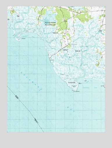
Ben Davis Point, NJ USGS Topographic Map
Click on map above to begin viewing in our Map Viewer.

This topographic map contains these locations and features:
Feature Name Type Latitude Longitude GNIS ID View Map
Abbot CreekStreamN39.3396°W75.2750°874233View Map
Ayres CreekStreamN39.3496°W75.3555°874435View Map
Back CreekStreamN39.3018°W75.2844°874447View Map
Back Creek PointCapeN39.2987°W75.2824°874449View Map
Back NeckCapeN39.3337°W75.2982°874451View Map
Bay PointCapeN39.2957°W75.2535°874548View Map
Bear Swamp CreekStreamN39.3359°W75.2716°874597View Map
Ben Davis Island (historical)IslandN39.2890°W75.2882°873763View Map
Ben Davis PointCapeN39.2890°W75.2882°874663View Map
Ben Davis Point ShoalBarN39.2582°W75.2899°874109View Map
Blews RunStreamN39.3505°W75.2583°874813View Map
Bridges Sticks CreekStreamN39.3457°W75.2682°874929View Map
Cabin CreekStreamN39.3481°W75.3644°875073View Map
Cabin IslandIslandN39.3368°W75.2894°875074View Map
Cedar CreekStreamN39.2988°W75.2512°875269View Map
Cohansey CoveBayN39.3448°W75.3469°875536View Map
Cohansey Inner LightLocaleN39.3473°W75.3644°875537View Map
Cohansey Outer LightLocaleN39.3446°W75.3671°875538View Map
Cohansey PointCapeN39.3429°W75.3560°875539View Map
Cohansey RiverStreamN39.3443°W75.3571°875540View Map
Cut ThroughChannelN39.3457°W75.3652°875788View Map
Dayton CreekStreamN39.3182°W75.2789°875819View Map
Division CreekStreamN39.3479°W75.3241°875929View Map
Dix Fish and Wildlife Management AreaParkN39.3543°W75.3163°883045View Map
Drum BedBayN39.3354°W75.2741°875976View Map
Drumbo CreekStreamN39.3489°W75.3417°875982View Map
Eastern CrossStreamN39.3237°W75.2782°876075View Map
Halka Nurseries AirportAirportN39.3666°W75.2680°884733View Map
Husted LandingPopulated PlaceN39.3515°W75.2571°877296View Map
Loyds CornerPopulated PlaceN39.3607°W75.3007°877978View Map
Middle Marsh CreekStreamN39.3398°W75.3260°878297View Map
Nantuxent CoveBayN39.2940°W75.2660°878686View Map
Ogden CreekStreamN39.3451°W75.2678°878945View Map
Old Hatch CreekStreamN39.3302°W75.2791°878957View Map
Oyster GutGutN39.3084°W75.3074°879076View Map
Pier Point CreekStreamN39.3033°W75.2863°879276View Map
Pier Point NeckCapeN39.2954°W75.2896°879277View Map
Ragged IslandIslandN39.3654°W75.3602°879584View Map
Rock CreekStreamN39.3506°W75.2693°879745View Map
Sayres NeckCapeN39.3212°W75.2557°880282View Map
Sayres PointCapeN39.2984°W75.2760°880283View Map
Sea BreezePopulated PlaceN39.3212°W75.3202°880444View Map
Sheep Pen CreekStreamN39.3437°W75.2812°880529View Map
Tarpon CoveBayN39.3001°W75.2699°881092View Map
Tarpon GutGutN39.3048°W75.2657°881093View Map
Tindall IslandIslandN39.3629°W75.3738°881194View Map
Tweed CreekStreamN39.3142°W75.2827°881312View Map
Western CrossStreamN39.3240°W75.2806°881739View Map

Note: Coordinates in the location and feature list above are referenced to NAD83 datum.


Copyright (C) 2008-2025 Ryan Niemi / Sunset Dynamics ... All Rights Reserved