TopoQuest Logo
Do you find TopoQuest useful?
Help keep TopoQuest running and adding new maps/features by donating!
Bitcoin:  19c7KJd3qBynnjoSw5npx9KScwjBe4ifkT
Litecoin:  LXs6TkuXGGXo1vDsWCkWVdjQX94eUKd6ui
Home View Maps Find Maps Find Places Resources & Links


Cedarville, New Jersey Topographic Map

USGS Map Title: Cedarville, NJ
USGS Map MRC: 39075C2
DRG (GeoTIFF) Download: o39075c2.tif


Neighboring USGS Topographic Map Quads:


  Shiloh, NJ  
39075D3
 

  Bridgeton, NJ  
39075D2
 

  Millville, NJ  
39075D1
 

  Ben Davis Point, NJ  
39075C3
 

  Cedarville, NJ  
39075C2
 

  Dividing Creek, NJ  
39075C1


  Fortescue, NJ  
39075B2
 

  Port Norris, NJ  
39075B1


Map MRC Location:

N40°
W76°
N40°
W75°
H8 H7 H6 H5 H4 H3 H2 H1
G8 G7 G6 G5 G4 G3 G2 G1
F8 F7 F6 F5 F4 F3 F2 F1
E8 E7 E6 E5 E4 E3 E2 E1
D8 D7 D6 D5 D4 D3 D2 D1
C8 C7 C6 C5 C4 C3 C2 C1
B8 B7 B6 B5 B4 B3 B2 B1
A8 A7 A6 A5 A4 A3 A2 A1
N39°
W76°
N39°
W75°

Cedarville, NJ USGS 1:24K Topographic Map Preview:
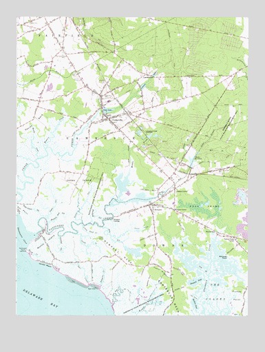
Cedarville, NJ USGS Topographic Map
Click on map above to begin viewing in our Map Viewer.

This topographic map contains these locations and features:
Feature Name Type Latitude Longitude GNIS ID View Map
Beach CreekStreamN39.2752°W75.2410°874567View Map
Bear SwampSwampN39.2957°W75.1494°874590View Map
Beaver DamLocaleN39.2854°W75.1421°874616View Map
Blackbird GutGutN39.2915°W75.2074°874791View Map
Blizzard Neck GutGutN39.2929°W75.2257°874814View Map
Boggy BranchStreamN39.3167°W75.1569°874840View Map
Bowers CreekStreamN39.3198°W75.2346°874869View Map
Bradford PointCapeN39.2654°W75.1782°874885View Map
Cabin RidgeRidgeN39.2705°W75.1772°875075View Map
Cedar BranchStreamN39.3192°W75.1514°875252View Map
Cedar Hill CemeteryCemeteryN39.3415°W75.1977°875289View Map
Cedar LakeReservoirN39.3361°W75.2007°875300View Map
Cedar Lake DamDamN39.3357°W75.2024°883902View Map
CedarvillePopulated PlaceN39.3326°W75.1996°875320View Map
Cedarville Census Designated PlaceCensusN39.3383°W75.2069°2389294View Map
Cedarville Fire Department Station 17BuildingN39.3346°W75.1924°2614470View Map
Coon TrapSwampN39.2865°W75.1824°874118View Map
Cumberland CountyCivilN39.3281°W75.1293°882275View Map
Dave's AerodromeAirportN39.3179°W75.2061°884697View Map
Downe Township AmbulanceBuildingN39.2921°W75.1610°2660101View Map
Downe Township Elementary SchoolSchoolN39.2971°W75.1653°2333267View Map
Downe Township Fire and Rescue Newport Volunteer Fire DepartmentBuildingN39.2958°W75.1765°2401674View Map
Dyer CoveBayN39.2607°W75.2091°876026View Map
Dyer CreekStreamN39.2635°W75.2110°876027View Map
Eagle Island GutGutN39.2948°W75.2405°876031View Map
Fortescue Fish and Wildlife Management AreaParkN39.2584°W75.1830°883042View Map
Fortescue Island (historical)IslandN39.2562°W75.1652°873764View Map
Fortescue NeckCapeN39.2562°W75.1652°876426View Map
Frames CornerPopulated PlaceN39.3034°W75.1638°876458View Map
Gandys BeachPopulated PlaceN39.2721°W75.2349°876544View Map
Grandad GutGutN39.2796°W75.2255°876703View Map
Hay GutGutN39.2834°W75.1982°877009View Map
Hollywood BeachLocaleN39.2754°W75.1366°877178View Map
Howells CreekStreamN39.3165°W75.2357°877271View Map
Iron BranchStreamN39.2669°W75.1466°877355View Map
Iron PointCapeN39.2579°W75.1541°877357View Map
Jones IslandIslandN39.3065°W75.2166°877485View Map
Lawrence Township Emergency Medical ServicesBuildingN39.3322°W75.1995°2401875View Map
Lawrence Township Emergency Medical ServicesBuildingN39.3322°W75.1995°2660099View Map
Little Pond CreekStreamN39.2874°W75.2142°877854View Map
Lone Tree CreekGutN39.2779°W75.1524°877901View Map
Lopers GutGutN39.2954°W75.2291°877939View Map
Lores IslandIslandN39.2826°W75.2038°877940View Map
Lummis Lake Lower DamDamN39.3451°W75.1830°883901View Map
Lummis LakesReservoirN39.3512°W75.1755°877993View Map
LummistownPopulated PlaceN39.3509°W75.1791°877995View Map
Middle BrookStreamN39.3109°W75.1885°878291View Map
Mile BranchStreamN39.3180°W75.1509°878327View Map
Money IslandCapeN39.2782°W75.2363°874108View Map
Myron L Powell Elementary SchoolSchoolN39.3398°W75.2008°2333401View Map
Nancy GutGutN39.2965°W75.2144°878683View Map
Nantuxent CreekStreamN39.2837°W75.2399°878687View Map
Nantuxent Fish and Wildlife Management AreaParkN39.3001°W75.2052°883029View Map
Nantuxent PointCapeN39.2776°W75.2452°878685View Map
New England CrossroadsPopulated PlaceN39.3612°W75.2252°883095View Map
NewportPopulated PlaceN39.2968°W75.1766°878784View Map
Newport LandingPopulated PlaceN39.2898°W75.1974°878785View Map
Newport NeckCapeN39.2723°W75.1913°878787View Map
Old Stone Church CemeteryCemeteryN39.3598°W75.2241°878968View Map
Padgetts CreekStreamN39.2623°W75.2042°879090View Map
Pages RunStreamN39.2982°W75.1952°879092View Map
Ponds CreekStreamN39.2840°W75.2168°879425View Map
Rattlesnake GutGutN39.3684°W75.2091°879620View Map
Shaws MillPopulated PlaceN39.3107°W75.1563°883096View Map
Shaws Mill PondReservoirN39.3152°W75.1546°880525View Map
Shaws Mill Pond DamDamN39.3123°W75.1557°883903View Map
Sheepkill PondLakeN39.2648°W75.1535°880530View Map
Sow and Pigs CreekStreamN39.2548°W75.1985°880775View Map
The GladesFlatN39.2598°W75.1430°881145View Map
Township of DowneCivilN39.2714°W75.1332°882061View Map
Township of FairfieldCivilN39.3715°W75.2455°882059View Map
Township of LawrenceCivilN39.3346°W75.1890°882060View Map
Turkey PointCapeN39.2587°W75.1310°881293View Map
Turkey Point CornerPopulated PlaceN39.2829°W75.1324°881294View Map
Wallens PondLakeN39.2554°W75.1538°881496View Map
Watsons CornerPopulated PlaceN39.2946°W75.1646°881626View Map
Weir CreekStreamN39.2600°W75.1453°874204View Map

Note: Coordinates in the location and feature list above are referenced to NAD83 datum.


Copyright (C) 2008-2024 Ryan Niemi / Sunset Dynamics ... All Rights Reserved