TopoQuest Logo
Do you find TopoQuest useful?
Help keep TopoQuest running and adding new maps/features by donating!
Bitcoin:  19c7KJd3qBynnjoSw5npx9KScwjBe4ifkT
Litecoin:  LXs6TkuXGGXo1vDsWCkWVdjQX94eUKd6ui
Home View Maps Find Maps Find Places Resources & Links


Shirley, Missouri Topographic Map

USGS Map Title: Shirley, MO
USGS Map MRC: 37090H8
DRG (GeoTIFF) Download: o37090h8.tif


Neighboring USGS Topographic Map Quads:


  Anthonies Mill, MO  
38091A1
 

  Ebo, MO  
38090A8
 

  Old Mines, MO  
38090A7
 

  Berryman, MO  
37091H1
 

  Shirley, MO  
37090H8
 

  Potosi, MO  
37090H7
 

  Courtois, MO  
37091G1
 

  Palmer, MO  
37090G8
 

  Belgrade, MO  
37090G7


Map MRC Location:

N38°
W91°
N38°
W90°
H8 H7 H6 H5 H4 H3 H2 H1
G8 G7 G6 G5 G4 G3 G2 G1
F8 F7 F6 F5 F4 F3 F2 F1
E8 E7 E6 E5 E4 E3 E2 E1
D8 D7 D6 D5 D4 D3 D2 D1
C8 C7 C6 C5 C4 C3 C2 C1
B8 B7 B6 B5 B4 B3 B2 B1
A8 A7 A6 A5 A4 A3 A2 A1
N37°
W91°
N37°
W90°

Shirley, MO USGS 1:24K Topographic Map Preview:
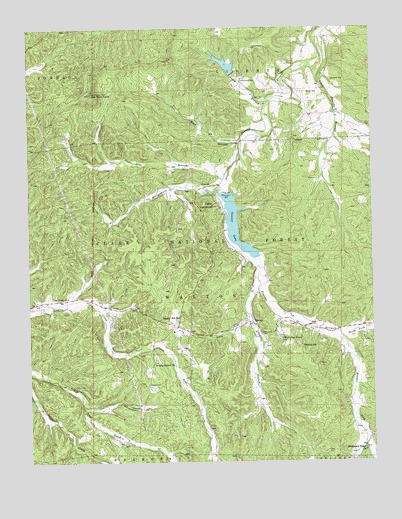
Shirley, MO USGS Topographic Map
Click on map above to begin viewing in our Map Viewer.

This topographic map contains these locations and features:
Feature Name Type Latitude Longitude GNIS ID View Map
Allen BranchStreamN37.9292°W90.9171°748571View Map
Ashly BranchStreamN37.9781°W90.9132°748622View Map
Blount CemeteryCemeteryN37.8975°W90.9573°748917View Map
Bunker Hill Baptist ChurchChurchN37.9503°W90.9324°736757View Map
Bunker Hill ChurchChurchN37.9167°W90.9462°749111View Map
Bunker Hill School (historical)SchoolN37.9506°W90.9321°736758View Map
Camp LakewoodPopulated PlaceN37.9484°W90.9304°749177View Map
Flint Hill School (historical)SchoolN37.9817°W90.8918°736761View Map
FloydPopulated PlaceN37.9542°W90.9487°739948View Map
Floyd Lookout TowerTowerN37.9814°W90.9774°755181View Map
Grassy Hollow Baptist Church CemeteryCemeteryN37.9031°W90.9554°1782174View Map
Grassy Hollow ChurchChurchN37.9031°W90.9554°750108View Map
Grassy Hollow School (historical)SchoolN37.9037°W90.9562°736759View Map
High Point - Missionary Ridge CemeteryCemeteryN37.8791°W90.8786°1782173View Map
High Point School (historical)SchoolN37.8764°W90.8790°736760View Map
Knox BranchStreamN37.9667°W90.9224°750637View Map
LevyPopulated PlaceN37.9134°W90.9451°736756View Map
Little Fourche a RenaultStreamN37.9998°W90.8918°750767View Map
Little Pilot KnobSummitN37.9812°W90.9774°750790View Map
Lost Creek CemeteryCemeteryN37.9228°W90.9860°1782175View Map
Lost Creek ChurchChurchN37.9228°W90.9860°753938View Map
Martin CemeteryCemeteryN37.9814°W90.8941°750947View Map
Middle Fork Fourche a RenaultStreamN37.9125°W90.8879°751035View Map
Missionary Ridge ChurchChurchN37.8781°W90.8785°751128View Map
Montgomery CreekStreamN37.9550°W90.9285°751143View Map
North Fork Fourche a RenaultStreamN37.9125°W90.8879°751338View Map
Potosi Fire Protection District House 2BuildingN37.9204°W90.9448°2620682View Map
Race CreekStreamN37.9181°W90.9215°751786View Map
Sayersbrook LakeReservoirN37.9893°W90.9280°763737View Map
Sayersbrook Lake DamDamN37.9867°W90.9268°763736View Map
Scott BranchStreamN37.9567°W90.9279°752065View Map
ShirleyPopulated PlaceN37.9150°W90.9193°752129View Map
Shirley Picnic AreaLocaleN37.9112°W90.9362°754378View Map
Shirley SchoolSchoolN37.9087°W90.9010°752132View Map
Shirley Union ChurchChurchN37.9145°W90.9179°1782194View Map
Shirley Union Church CemeteryCemeteryN37.9145°W90.9179°1782195View Map
Silvey CemeteryCemeteryN37.9525°W90.9300°752165View Map
Stephens CemeteryCemeteryN37.9848°W90.8890°752352View Map
Sunnen DamDamN37.9534°W90.9301°763735View Map
Sunnen LakeReservoirN37.9432°W90.9249°758349View Map
Township of WaltonCivilN37.9200°W90.9809°767515View Map
Washington CountyCivilN37.9617°W90.8774°758563View Map
White Oak Grove CemeteryCemeteryN37.9102°W90.9087°1782171View Map
White Oak Grove ChurchChurchN37.9106°W90.9082°752855View Map
Wilson Family CemeteryCemeteryN37.9107°W90.9079°1782172View Map

Note: Coordinates in the location and feature list above are referenced to NAD83 datum.


Copyright (C) 2008-2025 Ryan Niemi / Sunset Dynamics ... All Rights Reserved