TopoQuest Logo
Do you find TopoQuest useful?
Help keep TopoQuest running and adding new maps/features by donating!
Bitcoin:  19c7KJd3qBynnjoSw5npx9KScwjBe4ifkT
Litecoin:  LXs6TkuXGGXo1vDsWCkWVdjQX94eUKd6ui
Home View Maps Find Maps Find Places Resources & Links


Belgrade, Missouri Topographic Map

USGS Map Title: Belgrade, MO
USGS Map MRC: 37090G7
DRG (GeoTIFF) Download: o37090g7.tif


Neighboring USGS Topographic Map Quads:


  Shirley, MO  
37090H8
 

  Potosi, MO  
37090H7
 

  Mineral Point, MO  
37090H6
 

  Palmer, MO  
37090G8
 

  Belgrade, MO  
37090G7
 

  Irondale, MO  
37090G6
 

  Johnson Mountain, MO  
37090F8
 

  Banner, MO  
37090F7
 

  Graniteville, MO  
37090F6


Map MRC Location:

N38°
W91°
N38°
W90°
H8 H7 H6 H5 H4 H3 H2 H1
G8 G7 G6 G5 G4 G3 G2 G1
F8 F7 F6 F5 F4 F3 F2 F1
E8 E7 E6 E5 E4 E3 E2 E1
D8 D7 D6 D5 D4 D3 D2 D1
C8 C7 C6 C5 C4 C3 C2 C1
B8 B7 B6 B5 B4 B3 B2 B1
A8 A7 A6 A5 A4 A3 A2 A1
N37°
W91°
N37°
W90°

Belgrade, MO USGS 1:24K Topographic Map Preview:
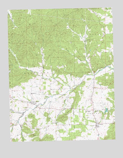
Belgrade, MO USGS Topographic Map
Click on map above to begin viewing in our Map Viewer.

This topographic map contains these locations and features:
Feature Name Type Latitude Longitude GNIS ID View Map
Aker HillSummitN37.7712°W90.8104°748565View Map
BelgradePopulated PlaceN37.7867°W90.8493°748769View Map
Belgrade DamDamN37.8400°W90.7985°764535View Map
Belgrade Methodist CemeteryCemeteryN37.7864°W90.8466°1759789View Map
Belgrade Post OfficePost OfficeN37.7862°W90.8488°2782921View Map
Belgrade SchoolSchoolN37.7953°W90.8485°748770View Map
Belgrade Volunteer Fire DepartmentBuildingN37.7865°W90.8485°2621116View Map
Belleview Collegiate InstitutionSchoolN37.7631°W90.7701°736838View Map
Belleview Presbyterian Church (historical)ChurchN37.7698°W90.7610°736837View Map
Bellvue CemeteryCemeteryN37.7698°W90.7621°748776View Map
Bennett Bryan CemeteryCemeteryN37.8098°W90.8346°749076View Map
Breckenridge School (historical)SchoolN37.7914°W90.8074°736841View Map
Bressie Lake DamDamN37.7634°W90.8151°765249View Map
Brock CreekStreamN37.7773°W90.8587°749028View Map
Bryan GristmillLocaleN37.8112°W90.8354°736836View Map
CaledoniaPopulated PlaceN37.7634°W90.7729°749157View Map
Caledonia CemeteryCemeteryN37.7784°W90.7757°749158View Map
Caledonia Fire Protection DistrictBuildingN37.7634°W90.7765°2621644View Map
Caledonia Post OfficePost OfficeN37.7681°W90.7730°2783082View Map
Carson CemeteryCemeteryN37.7794°W90.8407°1759790View Map
Church of GodChurchN37.8439°W90.7826°749354View Map
Clear CreekStreamN37.7985°W90.7988°749378View Map
Davis CemeteryCemeteryN37.8167°W90.8385°749578View Map
Dent BranchStreamN37.7973°W90.7993°749629View Map
Deslodge LandAreaN37.8109°W90.8562°736835View Map
Dry Bone ShaftMineN37.8728°W90.7612°736834View Map
Farquaher Lead DiggingsMineN37.8317°W90.7679°736832View Map
Flat CreekStreamN37.8214°W90.7804°749934View Map
Furnace CreekStreamN37.8117°W90.7724°750010View Map
Furnace Creek CemeteryCemeteryN37.8441°W90.7829°1759788View Map
Furnace Creek School (historical)SchoolN37.8445°W90.7821°736839View Map
Hunters Mill (historical)LocaleN37.8195°W90.7765°753097View Map
Hunters Mill BridgeBridgeN37.8114°W90.7737°736831View Map
Jane Bryan CemeteryCemeteryN37.7901°W90.8338°750499View Map
Janes CreekStreamN37.7687°W90.8646°750500View Map
Jumbo ShaftMineN37.8712°W90.7749°736833View Map
Kitchell HillSummitN37.7770°W90.8040°750628View Map
Lake Loomis DamDamN37.8234°W90.8218°764534View Map
Nicholson Iron BankMineN37.7970°W90.8210°736830View Map
North Fork Clear CreekStreamN37.8114°W90.8349°751335View Map
Number 267 DamDamN37.8450°W90.7851°764295View Map
Pleasant Grove ChurchChurchN37.7673°W90.8190°751652View Map
Pleasant Grove School (historical)SchoolN37.7639°W90.8265°736842View Map
Podorski Lake DamDamN37.8150°W90.8551°764536View Map
Reynolds BranchStreamN37.7753°W90.7624°751858View Map
Rieffer Lake DamDamN37.7750°W90.7668°764300View Map
Short-N-Ruff Airport (historical)AirportN37.7880°W90.7803°2679305View Map
Sloan School (historical)SchoolN37.7984°W90.7757°736840View Map
Spring Glen LakeReservoirN37.7778°W90.7602°758343View Map
Spring Glen Lake DamDamN37.7784°W90.7585°764537View Map
Turner HillSummitN37.7556°W90.8487°752627View Map
Valley High SchoolSchoolN37.7773°W90.7796°752686View Map
Village of CaledoniaCivilN37.7648°W90.7724°2397530View Map

Note: Coordinates in the location and feature list above are referenced to NAD83 datum.


Copyright (C) 2008-2025 Ryan Niemi / Sunset Dynamics ... All Rights Reserved