TopoQuest Logo
Do you find TopoQuest useful?
Help keep TopoQuest running and adding new maps/features by donating!
Bitcoin:  19c7KJd3qBynnjoSw5npx9KScwjBe4ifkT
Litecoin:  LXs6TkuXGGXo1vDsWCkWVdjQX94eUKd6ui
Home View Maps Find Maps Find Places Resources & Links


Albert Lea West, Minnesota Topographic Map

USGS Map Title: Albert Lea West, MN
USGS Map MRC: 43093F4
DRG (GeoTIFF) Download: o43093f4.tif


Neighboring USGS Topographic Map Quads:


  Freeborn, MN  
43093G5
 

  Hartland, MN  
43093G4
 

  Ellendale, MN  
43093G3
 

  Alden, MN  
43093F5
 

  Albert Lea West, MN  
43093F4
 

  Albert Lea East, MN  
43093F3
 

  Conger, MN  
43093E5
 

  Emmons, MN  
43093E4
 

  Glenville, MN  
43093E3


Map MRC Location:

N44°
W94°
N44°
W93°
H8 H7 H6 H5 H4 H3 H2 H1
G8 G7 G6 G5 G4 G3 G2 G1
F8 F7 F6 F5 F4 F3 F2 F1
E8 E7 E6 E5 E4 E3 E2 E1
D8 D7 D6 D5 D4 D3 D2 D1
C8 C7 C6 C5 C4 C3 C2 C1
B8 B7 B6 B5 B4 B3 B2 B1
A8 A7 A6 A5 A4 A3 A2 A1
N43°
W94°
N43°
W93°

Albert Lea West, MN USGS 1:24K Topographic Map Preview:
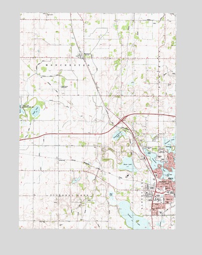
Albert Lea West, MN USGS Topographic Map
Click on map above to begin viewing in our Map Viewer.

This topographic map contains these locations and features:
Feature Name Type Latitude Longitude GNIS ID View Map
Albert Lea Country ClubLocaleN43.6697°W93.3883°1817569View Map
ArmstrongPopulated PlaceN43.6647°W93.4680°639442View Map
Armstrong (historical)LocaleN43.6647°W93.4680°2049729View Map
Armstrong Post Office (historical)Post OfficeN43.6647°W93.4680°2049730View Map
Ascension Lutheran ChurchChurchN43.6358°W93.3949°2049758View Map
Bancroft Bay ParkParkN43.6722°W93.3766°1817591View Map
Bellview ParkParkN43.6405°W93.3794°2049910View Map
Big Oak SchoolSchoolN43.7019°W93.3880°640108View Map
Central ChurchChurchN43.7083°W93.3810°641056View Map
Central Lutheran CemeteryCemeteryN43.7088°W93.3822°2049907View Map
City of ManchesterCivilN43.7254°W93.4512°2395825View Map
Concordia Lutheran Church Cemetery of Pickerel LakeCemeteryN43.6302°W93.4804°2049906View Map
County Ditch Number ElevenCanalN43.7152°W93.4394°1817556View Map
County Ditch Number FiftyeightCanalN43.7133°W93.4780°1817553View Map
County Ditch Number FiftyfourCanalN43.6719°W93.4997°1817551View Map
County Ditch Number NineCanalN43.6944°W93.4594°1817552View Map
County Ditch Number SixtyeightCanalN43.6413°W93.4422°1817549View Map
County Ditch Number SixtysixCanalN43.6702°W93.4835°1817550View Map
Dress Island ParkParkN43.6569°W93.3824°1817558View Map
Fountain LakeLakeN43.6586°W93.3830°643842View Map
Freeborn County Landing Strip (historical)AirportN43.7036°W93.4658°660271View Map
Gerold and Robert Pestorious Fish Pond DamDamN43.6533°W93.4552°1776568View Map
Graceland CemeteryCemeteryN43.6491°W93.3933°1817562View Map
Halls Lake State Wildlife AreaParkN43.6950°W93.4994°1817571View Map
Hayek Field ParkParkN43.6488°W93.3838°1817560View Map
Hopkins SchoolSchoolN43.6733°W93.4491°645185View Map
Interchange 154CrossingN43.6880°W93.4183°2049885View Map
Itasca CemeteryCemeteryN43.6766°W93.4035°1817557View Map
Itasca SchoolSchoolN43.6752°W93.3980°645538View Map
Judicial Ditch Number FiveCanalN43.7194°W93.4860°1817554View Map
Judicial Ditch Number TwentyoneCanalN43.7455°W93.3883°1817555View Map
Lake Val HallaReservoirN43.6531°W93.4545°1776569View Map
Lakeview Elementary SchoolSchoolN43.6547°W93.3799°1817559View Map
Lakeview ParkParkN43.6641°W93.3827°1817566View Map
ManchesterPopulated PlaceN43.7255°W93.4519°647432View Map
Manchester (historical)LocaleN43.7250°W93.4502°2049806View Map
Manchester City HallBuildingN43.7255°W93.4519°2049808View Map
Manchester Fire DepartmentBuildingN43.7241°W93.4520°2666711View Map
Manchester Post OfficePost OfficeN43.7255°W93.4519°2049807View Map
Mud LakeLakeN43.6449°W93.4264°1817565View Map
Norby SchoolSchoolN43.7347°W93.4194°648580View Map
North Edgewater ParkParkN43.6719°W93.3974°1817568View Map
Pickerel LakeLakeN43.6301°W93.4076°649375View Map
Pickerel Lake ChurchChurchN43.6291°W93.4783°649383View Map
Ruble SchoolSchoolN43.6475°W93.4294°650377View Map
Saint Johns Lutheran HomeHospitalN43.6566°W93.3905°2049784View Map
School Section LakeLakeN43.6793°W93.4206°651772View Map
Seventh Day Adventist ChurchChurchN43.6333°W93.3933°2049759View Map
Severson SchoolSchoolN43.7025°W93.4585°651875View Map
Shoff ParkParkN43.6538°W93.3919°1817561View Map
Sibley Elementary SchoolSchoolN43.6419°W93.3910°2049785View Map
Skyline MallLocaleN43.6444°W93.3885°2049764View Map
South Armstrong SchoolSchoolN43.6430°W93.4688°652266View Map
South Edgewater ParkParkN43.6661°W93.3905°1817567View Map
Southwest Junior High SchoolSchoolN43.6422°W93.3913°1817564View Map
Southwest ParkParkN43.6416°W93.3885°1817563View Map
Sugar LakeLakeN43.6929°W93.4871°652771View Map
Township of ManchesterCivilN43.7167°W93.4687°664886View Map
Township of Pickerel LakeCivilN43.6295°W93.4690°665291View Map
United Methodist ChurchChurchN43.6383°W93.3933°2049757View Map
Wedgewood ParkParkN43.6447°W93.3997°2049790View Map
West Freeborn CemeteryCemeteryN43.7497°W93.4779°653963View Map
West Freeborn ChurchChurchN43.7483°W93.4780°653964View Map
White LakeLakeN43.6622°W93.4133°654087View Map

Note: Coordinates in the location and feature list above are referenced to NAD83 datum.


Copyright (C) 2008-2025 Ryan Niemi / Sunset Dynamics ... All Rights Reserved