TopoQuest Logo
Do you find TopoQuest useful?
Help keep TopoQuest running and adding new maps/features by donating!
Bitcoin:  19c7KJd3qBynnjoSw5npx9KScwjBe4ifkT
Litecoin:  LXs6TkuXGGXo1vDsWCkWVdjQX94eUKd6ui
Home View Maps Find Maps Find Places Resources & Links


Emmons, Minnesota Topographic Map

USGS Map Title: Emmons, MN
USGS Map MRC: 43093E4
DRG (GeoTIFF) Download: o43093e4.tif


Neighboring USGS Topographic Map Quads:


  Alden, MN  
43093F5
 

  Albert Lea West, MN  
43093F4
 

  Albert Lea East, MN  
43093F3
 

  Conger, MN  
43093E5
 

  Emmons, MN  
43093E4
 

  Glenville, MN  
43093E3
 

  Lake Mills, IA  
43093D5
 

  Bristol, IA  
43093D4
 

  Fertile NE, IA  
43093D3


Map MRC Location:

N44°
W94°
N44°
W93°
H8 H7 H6 H5 H4 H3 H2 H1
G8 G7 G6 G5 G4 G3 G2 G1
F8 F7 F6 F5 F4 F3 F2 F1
E8 E7 E6 E5 E4 E3 E2 E1
D8 D7 D6 D5 D4 D3 D2 D1
C8 C7 C6 C5 C4 C3 C2 C1
B8 B7 B6 B5 B4 B3 B2 B1
A8 A7 A6 A5 A4 A3 A2 A1
N43°
W94°
N43°
W93°

Emmons, MN USGS 1:24K Topographic Map Preview:
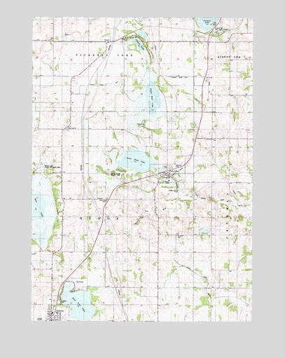
Emmons, MN USGS Topographic Map
Click on map above to begin viewing in our Map Viewer.

This topographic map contains these locations and features:
Feature Name Type Latitude Longitude GNIS ID View Map
Ann and Leo Donahue Wildlife Management AreaParkN43.5680°W93.4308°2049699View Map
Arrowhead Golf and Country ClubLocaleN43.5166°W93.4724°2049852View Map
Bear LakeReservoirN43.5383°W93.4935°1776986View Map
Bear Lake ChurchChurchN43.5794°W93.4794°639778View Map
Bear Lake Concordia Lutheran CemeteryCemeteryN43.5786°W93.4794°2049904View Map
Bear Lake DamDamN43.5383°W93.4935°1776985View Map
Bear Lake SchoolSchoolN43.5505°W93.4730°639779View Map
Bear Lake State Wildlife Management AreaParkN43.5658°W93.4974°1817546View Map
Brush Hill CemeteryCemeteryN43.5498°W93.4578°640561View Map
Church LakeLakeN43.6136°W93.4395°641215View Map
City of EmmonsCivilN43.5066°W93.4852°2394691View Map
City of Twin LakesCivilN43.5609°W93.4234°2397072View Map
Clover SchoolSchoolN43.5791°W93.4738°641354View Map
EmmonsPopulated PlaceN43.5019°W93.4883°659990View Map
Emmons (historical)LocaleN43.5027°W93.4863°2049851View Map
Emmons Fire DepartmentBuildingN43.5001°W93.4884°2049846View Map
Emmons Lutheran ChurchChurchN43.5036°W93.4858°2049849View Map
Emmons Post OfficePost OfficeN43.5016°W93.4883°2049848View Map
Emmons Trailer CourtPopulated PlaceN43.5019°W93.4883°2049845View Map
Everhart LakeLakeN43.6181°W93.4382°643474View Map
Flamme SchoolSchoolN43.6155°W93.4569°643725View Map
Flaten SchoolSchoolN43.5108°W93.4360°643732View Map
Freeborn County Waterfowl Production AreaParkN43.5430°W93.4118°2765309View Map
Gateway ParkParkN43.5075°W93.4819°1817544View Map
Glenville-Emmons Public SchoolSchoolN43.5036°W93.4883°2049850View Map
Hayne SchoolSchoolN43.5747°W93.3941°644795View Map
Jeklyn SchoolSchoolN43.6155°W93.4266°645617View Map
Judicial Ditch Number NineCanalN43.6005°W93.4099°1817543View Map
KQPR-FM (Albert Lea)TowerN43.5816°W93.3952°663002View Map
Lakeview Mobile Home ParkPopulated PlaceN43.5638°W93.4224°2049802View Map
Lower Twin LakeLakeN43.5659°W93.4412°647269View Map
Lunder ChurchChurchN43.5744°W93.3977°647300View Map
Lunder Lutheran CemeteryCemeteryN43.5748°W93.3980°2049903View Map
Oak Knoll SchoolSchoolN43.5141°W93.3905°648830View Map
Pickerel Lake ChurchChurchN43.6172°W93.4466°649382View Map
Pickerel Lake ParkParkN43.6225°W93.3974°1817547View Map
Saint James Catholic ChurchChurchN43.5605°W93.4252°2049801View Map
Saint James CemeteryCemeteryN43.5349°W93.4179°650614View Map
Shady Oak CemeteryCemeteryN43.6160°W93.4482°1817548View Map
State Line LakeLakeN43.5075°W93.4735°652589View Map
Sunnyside SchoolSchoolN43.6033°W93.3880°652830View Map
Township of NundaCivilN43.5434°W93.4688°665184View Map
Twin LakesPopulated PlaceN43.5597°W93.4230°653454View Map
Twin Lakes (historical)LocaleN43.5586°W93.4224°2049796View Map
Twin Lakes City HallBuildingN43.5597°W93.4249°2049798View Map
Twin Lakes Fire DepartmentBuildingN43.5601°W93.4245°2049800View Map
Twin Lakes Post OfficePost OfficeN43.5605°W93.4224°2049797View Map
Twin Lakes SchoolSchoolN43.5355°W93.4274°653459View Map
Upper Twin LakeLakeN43.5900°W93.4345°653572View Map
White Woods County ParkParkN43.5611°W93.4516°1817545View Map

Note: Coordinates in the location and feature list above are referenced to NAD83 datum.


Copyright (C) 2008-2024 Ryan Niemi / Sunset Dynamics ... All Rights Reserved