TopoQuest Logo
Do you find TopoQuest useful?
Help keep TopoQuest running and adding new maps/features by donating!
Bitcoin:  19c7KJd3qBynnjoSw5npx9KScwjBe4ifkT
Litecoin:  LXs6TkuXGGXo1vDsWCkWVdjQX94eUKd6ui
Home View Maps Find Maps Find Places Resources & Links


Siloam Springs, Missouri Topographic Map

USGS Map Title: Siloam Springs, MO
USGS Map MRC: 36092G1
DRG (GeoTIFF) Download: o36092g1.tif


Neighboring USGS Topographic Map Quads:


  Nichols Knob, MO  
36092H2
 

  Dyestone Mountain, MO  
36092H1
 

  Willow Springs South, MO  
36091H8
 

  Dora, MO  
36092G2
 

  Siloam Springs, MO  
36092G1
 

  Pomona, MO  
36091G8
 

  Cureall NW, MO  
36092F2
 

  Pottersville, MO  
36092F1
 

  South Fork, MO  
36091F8


Map MRC Location:

N37°
W93°
N37°
W92°
H8 H7 H6 H5 H4 H3 H2 H1
G8 G7 G6 G5 G4 G3 G2 G1
F8 F7 F6 F5 F4 F3 F2 F1
E8 E7 E6 E5 E4 E3 E2 E1
D8 D7 D6 D5 D4 D3 D2 D1
C8 C7 C6 C5 C4 C3 C2 C1
B8 B7 B6 B5 B4 B3 B2 B1
A8 A7 A6 A5 A4 A3 A2 A1
N36°
W93°
N36°
W92°

Siloam Springs, MO USGS 1:24K Topographic Map Preview:
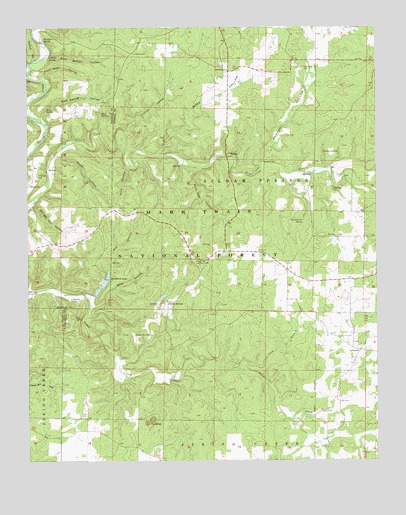
Siloam Springs, MO USGS Topographic Map
Click on map above to begin viewing in our Map Viewer.

This topographic map contains these locations and features:
Feature Name Type Latitude Longitude GNIS ID View Map
Anne HollowValleyN36.8348°W92.0893°748595View Map
Blue Hole HollowValleyN36.8345°W92.0635°748925View Map
Braddock LakeLakeN36.8020°W92.0971°748988View Map
Braddock Lake DamDamN36.8001°W92.0968°765125View Map
Cathole SpringSpringN36.8664°W92.1172°749253View Map
Collins CemeteryCemeteryN36.7859°W92.0140°749426View Map
Dark Bottom HollowValleyN36.8656°W92.1179°749568View Map
GrimmetPopulated PlaceN36.7814°W92.0065°750166View Map
Hay HollowValleyN36.7973°W92.1018°750262View Map
Hopkins School (historical)SchoolN36.7676°W92.0138°734237View Map
HortonPopulated PlaceN36.8703°W92.0740°735095View Map
Horton CemeteryCemeteryN36.8678°W92.0868°750401View Map
Horton HollowValleyN36.8414°W92.0896°750403View Map
Horton TrailheadLocaleN36.8698°W92.0857°753934View Map
Kenyon HollowValleyN36.8359°W92.0415°750593View Map
Lick BranchStreamN36.7764°W92.0499°750705View Map
Lovers LeapCliffN36.8364°W92.0407°750870View Map
Martin HillSummitN36.7992°W92.0796°735094View Map
May Hollow YCC CampLocaleN36.8020°W92.0988°754413View Map
Mine HollowValleyN36.7951°W92.1013°751108View Map
Mine Hollow BranchStreamN36.7995°W92.0938°735093View Map
Mitts CemeteryCemeteryN36.7634°W92.1068°751134View Map
Moss HollowValleyN36.8387°W92.0793°751164View Map
Oak Grove CemeteryCemeteryN36.8634°W92.0263°751372View Map
Oak Grove ChurchChurchN36.8628°W92.0535°751377View Map
Oak Grove SchoolSchoolN36.8742°W92.0307°734234View Map
Payne KnobSummitN36.8073°W92.0652°735092View Map
Pease MillLocaleN36.7876°W92.0757°735091View Map
Pumpkin Center Fire DepartmentBuildingN36.8048°W92.0326°2621460View Map
Rattlesnake SpringSpringN36.8195°W92.0266°751811View Map
Ridge Runner NR TrailTrailN36.8209°W92.0746°754045View Map
Rocky HollowValleyN36.8389°W92.1135°751942View Map
RooseveltPopulated PlaceN36.8306°W92.1235°751960View Map
Round Top School (historical)SchoolN36.8434°W92.1210°734233View Map
Shingle Mill HollowValleyN36.8248°W92.1232°752125View Map
Siloam Lookout TowerTowerN36.8076°W92.0654°755403View Map
Siloam SpringsPopulated PlaceN36.7956°W92.0754°752156View Map
Siloam Springs CemeteryCemeteryN36.7867°W92.0876°752157View Map
Siloam Springs Quad Number 1 DamDamN36.7967°W92.0768°765126View Map
Siloam Springs School (historical)SchoolN36.7948°W92.0749°735090View Map
Smallpox SpringSpringN36.8715°W92.1192°752209View Map
Star SchoolSchoolN36.8114°W92.0432°734236View Map
Steer Stall HollowValleyN36.8612°W92.1190°752348View Map
Still SpringSpringN36.8501°W92.0988°752363View Map
Sues SpringSpringN36.8514°W92.1183°752408View Map
Sues Spring HollowValleyN36.8492°W92.1199°752409View Map
Tabor SpringSpringN36.7967°W92.1097°754412View Map
The SinksBasinN36.7617°W92.0815°752523View Map
Thornton CemeteryCemeteryN36.8326°W92.1218°752536View Map
Township of Siloam SpringsCivilN36.8282°W92.0479°766788View Map
Turkey SpringSpringN36.8391°W92.0137°752612View Map
Turnbull HollowValleyN36.8653°W92.1229°752622View Map
Turner SchoolSchoolN36.8214°W92.0054°734235View Map

Note: Coordinates in the location and feature list above are referenced to NAD83 datum.


Copyright (C) 2008-2024 Ryan Niemi / Sunset Dynamics ... All Rights Reserved