TopoQuest Logo
Do you find TopoQuest useful?
Help keep TopoQuest running and adding new maps/features by donating!
Bitcoin:  19c7KJd3qBynnjoSw5npx9KScwjBe4ifkT
Litecoin:  LXs6TkuXGGXo1vDsWCkWVdjQX94eUKd6ui
Home View Maps Find Maps Find Places Resources & Links


Dyestone Mountain, Missouri Topographic Map

USGS Map Title: Dyestone Mountain, MO
USGS Map MRC: 36092H1
DRG (GeoTIFF) Download: o36092h1.tif


Neighboring USGS Topographic Map Quads:


  Cabool SW, MO  
37092A2
 

  Cabool SE, MO  
37092A1
 

  Willow Springs North, MO  
37091A8
 

  Nichols Knob, MO  
36092H2
 

  Dyestone Mountain, MO  
36092H1
 

  Willow Springs South, MO  
36091H8
 

  Dora, MO  
36092G2
 

  Siloam Springs, MO  
36092G1
 

  Pomona, MO  
36091G8


Map MRC Location:

N37°
W93°
N37°
W92°
H8 H7 H6 H5 H4 H3 H2 H1
G8 G7 G6 G5 G4 G3 G2 G1
F8 F7 F6 F5 F4 F3 F2 F1
E8 E7 E6 E5 E4 E3 E2 E1
D8 D7 D6 D5 D4 D3 D2 D1
C8 C7 C6 C5 C4 C3 C2 C1
B8 B7 B6 B5 B4 B3 B2 B1
A8 A7 A6 A5 A4 A3 A2 A1
N36°
W93°
N36°
W92°

Dyestone Mountain, MO USGS 1:24K Topographic Map Preview:
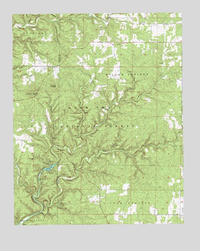
Dyestone Mountain, MO USGS Topographic Map
Click on map above to begin viewing in our Map Viewer.

This topographic map contains these locations and features:
Feature Name Type Latitude Longitude GNIS ID View Map
Blue Buck KnobSummitN36.9523°W92.1113°748919View Map
Blue Buck Lookout TowerTowerN36.9523°W92.1113°755002View Map
Blue Rock ChurchChurchN36.9684°W92.0952°748932View Map
Brushy CreekStreamN36.9476°W92.0457°749060View Map
C C C Camp (historical)LocaleN36.9337°W92.0504°734221View Map
Carman SpringSpringN36.9189°W92.0596°749216View Map
Carmen Springs Wildlife Refuge Management AreaParkN36.9209°W92.0474°754408View Map
Carroll CemeteryCemeteryN36.9039°W92.0879°749227View Map
Clearwater Reach Picnic AreaLocaleN36.9084°W92.1035°754054View Map
Cord HollowValleyN36.8926°W92.1107°749472View Map
Crooked CreekStreamN36.9181°W92.0804°749526View Map
Dry Creek ChurchChurchN36.8803°W92.0043°749718View Map
Dyestone MountainSummitN36.9570°W92.0929°749757View Map
Fern Glen School (historical)SchoolN36.9798°W92.1046°734215View Map
Fern Ridge SchoolSchoolN36.9542°W92.0640°734217View Map
Fields StoreLocaleN36.9678°W92.0952°734216View Map
Flatrock SchoolSchoolN36.9251°W92.1188°734218View Map
Fox HollowValleyN36.9851°W92.1235°749974View Map
Galloway SpringSpringN36.8876°W92.0908°750018View Map
Group Camp SpringSpringN36.9058°W92.1055°754055View Map
Hellroaring SpringSpringN36.9111°W92.0992°750283View Map
Little Indian CreekStreamN36.9928°W92.1174°750775View Map
Middle Indian CreekStreamN36.9959°W92.0921°751041View Map
Noblett CreekStreamN36.8826°W92.1052°751323View Map
Noblett LakeReservoirN36.9088°W92.0987°758318View Map
Noblett Lake CampgroundLocaleN36.9020°W92.1060°751324View Map
Noblett Lake DamDamN36.9084°W92.1035°762969View Map
Noblett MillLocaleN36.9623°W92.0154°735080View Map
Noblett School (historical)SchoolN36.9606°W92.0010°734220View Map
Noblett TrailheadLocaleN36.9042°W92.0957°754056View Map
North Fork Spring CreekStreamN36.9228°W92.0085°751344View Map
OzarksAreaN36.9167°W92.0168°760190View Map
Pine Grove ChurchChurchN36.9939°W92.0282°751606View Map
Pine Grove SchoolSchoolN36.9939°W92.0138°751607View Map
Pleasant Hill School (historical)SchoolN36.8981°W92.0618°734219View Map
Poison HollowValleyN36.9073°W92.0779°751686View Map
Rockhouse HollowValleyN36.9226°W92.0946°751930View Map
Rockhouse SpringSpringN36.9264°W92.0964°751932View Map
South Fork Spring CreekStreamN36.9228°W92.0085°752261View Map
Sparkling HollowValleyN36.9951°W92.0949°752276View Map
Spring HollowValleyN36.9189°W92.0527°752313View Map
Sugar Hill CampgroundLocaleN36.9064°W92.0974°754053View Map
Tater HillSummitN36.9748°W92.0882°752495View Map
Twin Bridges Volunteer Fire DepartmentBuildingN36.9686°W92.0927°2621370View Map
Twin MountainSummitN36.9414°W92.0871°752643View Map
West Liberty SchoolSchoolN36.9898°W92.0593°734214View Map
Willow Springs Ranger DistrictForestN36.8917°W92.1043°754435View Map
Wolf HollowValleyN36.8753°W92.1232°752955View Map

Note: Coordinates in the location and feature list above are referenced to NAD83 datum.


Copyright (C) 2008-2024 Ryan Niemi / Sunset Dynamics ... All Rights Reserved